8am
26.1 degrees, clear sky – lovely. Five more backpacker vehicles arrived last
night filling up the small area here but they were all gone by the time we got
moving.
Drove
back to Guilderton and the mouth of the Moore River. This area was originally
known as Gabbadah. About 1905 a 100 acre block owned by Henry Brockman was made
a reserve for picnicking and camping. A well and three cottages were built in
1907, people were charged one shilling per week for the use of these cottages.
The new town of Guilderton was gazetted on 30th Nov, 1951, after the
guilders that were found from the Dutch sailing ship, ‘Vergulde Draeck’, which
was wrecked north of Seabird (another beach town north of here) in 1656.
We
drove around to the north end, Wreck Point, to check out the big lighthouse
made of specially tapered red clay bricks. It was built in 1983 with an
automatic marine beacon. It was the only major navigation aid between Fremantle
and Jurien Bay and is also the last to be built in WA.
Got
our morning exercise walking up to it!!
Back
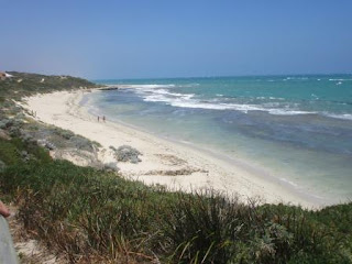
to the van looking south over the beach in front of Guilderton.
Drove
back though the nice homes to the lookout over the mouth of the Moore River.
Looking over the caravan park which I think is the site of the camping reserve
created 110 years ago.
Upstream
of the river then to the closed mouth. The sandbar usually opens several times
a year, mainly in winter and spring when there have been heavy rains in the
catchment. In summer, when flow reduces, the ocean waves build up the bar,
damming the estuary and turning the estuary into a long freshwater lake. Very
tannin stained at the moment.
Walked
to the other lookout platform over the beach to read about the ships wrecked
around this area and the aboriginal history. The stairs down to the beach are
closed at the moment. The wind is cold and strong so we will head down to the
river for a cuppa in the sunshine.
Cute
chap in the roundabout peering to the mouth of the river.
Had
our cuppa enjoying the sun’s warmth and the lovely view. No pelicans at the
moment but these three are interesting.
Walked
along the foreshore reading the information boards.
Another
bendy tree but at least it has the shed to lean on!! The other one looks like
it is reaching out for cars.
Drove
along the river on the high bank – looking across the what they call ‘The
Desert’ – white sand dune.
Further
along to where Silver Creek flows into the river or is it the river going back
up the creek!!
Zoomed
in on a funny looking house.
Back
to the highway and past where we parked last night – all clear now.
Turned
off the highway to the coast and the town of Two Rocks. We found Leeman’s Boat
Landing so went for a look. Nice view south.
Walked
down to the beach where a big rock is. There is another one on the edge of the
marina – not sure if these are the ‘Two Rocks’ the town is named after.
Drove
up to the marina – another angle of the other rock. The beach sign says this is
Wreck Point.
I
had read about a big statue in Two Rocks near the IGA. We found it but it is in
private property next door. There was a sign saying the area was being redone
but it doesn’t look like much has happened for a long time. Zoomed in on King
Neptune. Whoever did him was very talented.
Found
some dolphins near another gate. I wonder what other treasures are hidden in
the bush.
Continued
along the coast road which isn’t near the coast really. Lots of housing development
between Two Rocks and the next town of Yanchep. We found a spot to park and
have lunch near Yanchep Lagoon.
Looking
south.
Headed
east again then turned off into the Yanchep National Park. Our year National
Parks Pass has been great value. There is a campground here but I didn’t
realise it was a book on line one but the caretaker had room for us so it was
all good. We parked on the car park area which they now use for vans etc to
stay.
Went
for a walk along the track to the Visitors Centre. Pretty banksia flower.
Found
a very tall flower of a grass tree – the bees like it too.
The
Visitors Centre is in McNess House. The house was built around the remains of a
two-roomed stone hut called the hunting lodge, which dates back as far as the
1880s.
Lovely
view down to Loch McNess.
Inside
Henry White was sitting quietly. He found of the Crystal Cave in 1903 and was
co-founder of the Cabaret Cave (1902).
Some great old photos.
Found
some info on the grass tree – called Balga.
A
section of the wall was left unplastered to show the original wall.
Information
about Sir Charles McNess – but it didn’t come out too well.
There
are nine walking trails ranging from 500m to 52km. We decided on the 2.7km
wetlands one – a walk around Loch NcNess. It was originally called Lake Yanchep
and was dredged in 1932 and renamed in 1935 and renamed Loch McNess after the
philanthropist Sir Charles McNess who donated a lot of money to help the
unemployed. That money was used to employ sustenance workers on major developments
in this park. Interesting canoe!!
Walked down to the platform by the water. The tide seems to be out!! The water for the loch comes from an aquifer on the Darling Scarp which also provides Perth and surrounds with its drinking water etc. Sadly the level in the aquifer is not keeping up with demand so these wetland areas aren’t getting the usual water allocation. The water people are trying desalination plants etc to try and get more water for the growing towns around Perth and Perth itself.
Lots
of ducks and ducklings.
As
the water level was down it was just a walk through the bushes. Eventually on
the other side of the lake we crossed a bridge where an old water pumping
station used to be.
Across
another bridge then back to the lovely picnic areas again. A huge Balga with
info about how long they take to grow, 1 inch per year.
Walked
down the old boat ramp made of limestone blocks.
When
the Loch was full – last time was 9 years ago, people could hire boats and row
around the Loch. They would come in around this island to the jetty. Now it
just has a sculpture of pipes and taps.
A
couple of kangaroos and joeys are enjoying the island.
Into
the enclosure, first through the wildflower gardens – nothing flowering now
except a few kangaroo paws etc. Then into the koala enclosure where we spotted
8 koalas. 4 in each enclosure. Only one was awake and having a snack. The
koalas were first brought here in 1938 from Perth Zoo.
Back
to the van for a cuppa then we headed off to check out the Boomerang Gorge. A
bit of info along the way and lots of bees making their hives up high on the
stony outcrops.
Found
a cave to check out.
Further
along we found the Dingo Cave.
Some
more info as we came to the end of the gorge. Not really a gorge though but
interesting enough. There was a platform here on the edge of a pool in the
1930s where they had concerts etc. Bit hard to imagine now as it is overgrown
with plants.
We
continued on up the hill and then around to Crystal Cave. Closed at the moment
but there were info boards to read. It is $15 each to go in and as we have done
a few caves we decided to give it a miss. Would be interesting to attend a
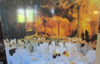
dinner or wedding in the Cathedral Cave though.
Info
about the lack of water now – the caves used to have a stream running through
them.
Back
to the van – photographed the rest of the info from the little history book.
The National Park has an interesting history.
Left
Steve at the van and I walked over to check out Gloucester House.
One
of the trams they used to provide accommodation near Boomerang Gorge etc.
It
is a large building – the other side of the front and then down the side.
Continued
on to Yanchep Inn. The kangaroos love the lush green grass.
Interesting
fountain made from limestone rocks – no water though.
Had
a look inside. A bit more info to read. During WW2 it was used as a hospital.
Back
to the van for drinkies. Our neighbours are from Cairns too but had only been
there 10 years or so.
Cool
evening so had to close up the van again.


No comments:
Post a Comment