6am
19.8 degrees and clear sky. Early start as we are heading north to check out
Francois Peron National Park. The NP office gave us permission to leave the van
in the carpark of the old homestead and will let the Ranger know we will be in
the park for 3 nights. The park has a lot of soft sand so we can’t take the van
with us. We unloaded stuff out of the truck and set it up again for us to live
out of there and when we go to Steep Point too.
Nice
entrance sign.
Around
the south edge of Hamelin Pool with flat salt bushes.
Past
the turn off to Steep Point – will go there on our way out of Shark Bay.
Up
a red sand hill – they say Shark Bay is where the red desert sands meet the
sea.
Nice
view (too hard to photograph though) back over Hamelin Pool which is huge and
we would call it a bay. It is called a pool as there is a natural bar across
the north end of it which limits the water flow in and out of the area.
Continued
on through low shrubs in the red sand and dry salt pans covered in little salt
bushes as we crossed the south end of the Nango Peninsula.
Passed
the turn off to Nango Bay which was once a pastoral lease but is now a holiday
resort and the rest was bought for conservation, which is on the south-west
side of the peninsula – see the map.
Turned
off to check out Shell Beach Conservation Park. Checked out the information
boards. We won’t be swimming here as the sea water is the same as Hamelin Pool
– twice as salty as normal sea water and the tide is out.
They
have erected a vermin fence to try and protect this peninsula’s wildlife.
More
information about shells being used as building blocks. There is a shell quarry
on the other side of the vermin fence.
Walked
down on the wide white shell covered beach.
I
found some shells to photograph.
Looking
over L’haridon Bight which is also protected by the Faure Sill to the north.
Walked
along the beach to the vermin fence. Lots of other shells here too.
The
Hamelin Cockle is hard here – ready to make some bricks.
The
vermin fence.
Looking
back down the beach.
Up
over a rise which is a small spit that divides Shell Beach from the next beach
and gives a nice view over L’haridon Bight.
Past
the turn off into Goulet Bluff. One of 4 council camp areas along this west
coast but you can only spend one night at only one of them for $15. They are
certainly protecting the caravan parks in Denham.
Continued
along the drive to a lookout over the west bay as we start up the Peron
Peninsula. The hard rock here is called Tamala Limestone. Didn’t see any ‘no
camping’ signs here!
The
land on the other side is the next peninsula over which is part of the Steep
Point area.
Spotted
some black and cream goats on this side of the vermin fence – obviously they
haven’t been caught yet. There were a couple of cute ‘kids’ with them too.
Just
as we got back onto the main road Steve spotted 3 emus in the bush – I missed
them.
We
turned off again to check out another camping area called Whalebone Bay as we
might stop here on the way back out. Nice white bluff at the other end. There
is another one called Fowlers Camp and then Eagle Bluff which has a boardwalk
to check out later.
Crossed
the 26th Parallel line. We have crossed this line heaps of times
this year.
Two
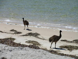
emus decided to wander across the road – Steve slowed down and one crossed
before the other cars reached us. The other one went back the other way.
Turned
onto another dirt track for a great view from Denham Lookout. Zoomed in on the
salt mine at a place called Useless Loop. Not sure if it is operational as
there is no information about it in the brochures. The boats are moored out
away from Denham. Denham is the most westerly settlement of Australia and was
originally a pearling camp named ‘Freshwater Camp’. It later developed into a
township that serviced the pearling, pastoral and fishing industries of Shark
Bay. It was proclaimed a town site on 3 May 1898 and later named ‘Denham’ after
Captain Henry Mangles Denham of the Royal Navy. Denham’s streets were once
paved with pearl shells but of course as the town grew they put bitumen over
the shells.
Down
by the beach is the Thong Shack so we drove down for a look while we had a
cuppa. Obviously someone started it by collecting the ‘lost’ thongs then it
became a place for people to leave their calling cards.
Lots
of shells on the beach.
I
found a pair of old thongs and decided we should leave our calling card too.
Headed
into Denham. Four wind turbines were slowing going around. Nice entrance sign –
famous for all the seagrass here and the dugongs.
We
pulled up to check out the information. Someone is digging out the red sand.
History
information, lots of shipwrecks and lovely beaches. The Peron Station was right
in the middle of the town. The town’s drinking water is desalinated artesian
water.
Drove
down to the water front then turned left and drove to the end which looks back
to the lookout we were just at. The beach isn’t quite as pretty as on the
information board – we obviously time it when the sea grass is breaking up.
We
pulled up and when I got out I spotted Daddy emu with his 6 chicks eating the
berries off this bush right by the road. We had heard they are very friendly
and wander all over the town. I took a video of them.
Great
aerial photo of Denham from the brochure.
Put
on our hats and headed off to follow the town history walk. It is sunny and
warm but the breeze is nice.
Great
playground.
Seagrass is a bit of a problem on the boat ramp.
More
emus.
Shiny
boards make it hard to read in the bright sunshine. The Malgana Aborigines
called this area Gutharraguda which means Two Waters – because of the two
protected bays.
Continued
back along the esplanade reading the signs.
This
sculpture is in front of a swimming area.
As
I walked past the shelter I realised there was a face of an aborigine on the
wall. Obviously to do with the next information board we read about the local
aborigines.
An
old pearling lugger has come back home to Denham – interesting story. Now it is
just a resting place for the sea gulls and cormorants.
The
last one on the foreshore. William Dampier named the area Sharks Bay in 1699 as
he mostly saw sharks.
We
walked up the rise to the site of the old police station, gaol and stables. The
station has gone but the gaol and stables are still at the back.
Up
the hill and across to Pioneer Park – the site of Shark Bay’s first cemetery.
There is only one grave left here and the war memorial has been added to the
park. Also there is a memorial to the early navigators and the rock that
Dampier etched his name into.
The
frangipani trees’ leaves are so glossy and the flowers smell wonderful.
Nice
view across the water too.
More
emus are wandering around people’s yards.
The
church made of shells.
Back
down to the foreshore. A park has been created in honour of a local chap.
We
skipped the Discovery and Information Centre – will do that when we return.
The
most western restaurant in Australia is also made of shells, The Old Pearler. Unfortunately it
wasn’t open so we just peered in the windows.
Across
the road is a new tavern and hotel which replaced the old Pearler’s Rest.
Up
the road was the site of the old Peron Station homestead and shearing sheds
etc.
Had
lunch then bought some bait and a yummy ice-cream. You could really taste the
mango. Denham is a lovely little town and it is really cute having the emus
wandering around.
Headed
out of town and up to Nicholson Point lookout. Took a video of the view.
Little
Lagoon’s creek flows out to the sea.
Drove
to the other end of it. Looking across the Lagoon to the sea in the distance.
Down
to the day use area. These lagoons (gypsum clay pans) are called Birridas.
Continued
along the road to Monkey Mia – we aren’t worrying about going there as we have
seen heaps of dolphins and they only select one person to feed them any case.
We heard there are only two dolphins coming in to feed at the moment.
Turned
off the bitumen onto the dirt road into Francois Peron National Park. Stopped
at the ‘pay station’ and dropped out entrance fee of $15 and $11 each per night
into the box. We have paid for three nights. At least you don’t have to book a
campsite here like we will have to do for Steep Point. Road corrugated but not
bad.
I
tried to get a photo of a dry birrida – salt pan.
Over
a rise – looking down on the Peron Station homestead precinct. It is now a
museum looked after by the National Park. It was bought by the government in
1990.
We
parked and went for a look around. The museum was closed but there was some
information around the back. Looks like we have some lovely places to explore.
Will
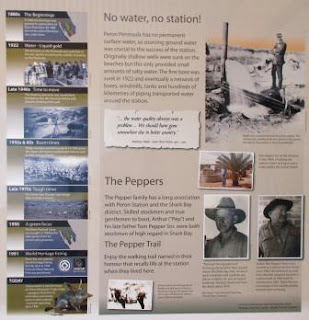
follow the Pepper Trail though first we wanted to check out the artesian hot
tub. It is hot, 40 degrees.
Wandered
along the trail reading all the information.
Around
to the shearing shed etc.
Time
for some dinner, then a bath.
Shearers’
quarters – flow through ventilation.
Back
around to the shearing shed – last sign about a shelter place for the sheep.
Needs a roof. The signs were very informative.
Heard
a noise and spotted three kangaroos trying to get away from us. They all tried
to jump the fence but crashed instead. Eventually they jumped off along the
fence-line.
Chose
a spot to leave the van and finished setting the truck up for our 3 night stay.
Took a photo in case it isn’t here when we return!
3pm
- Went for a dip in the hot tub. Got Steve to try it out first.
Then
he got hold of the camera – I have deleted a lot of his photos, ‘not for publication’.
After the initial heat hitting your skin it was very nice.
Just
when you think you have the place to yourself, more people arrived. Dried off
then drove around to the air down area. A 4WD with van was in front of us – so
much for leaving our van behind. The National Parks provide the air hoses here.
Steve chose to use his own.
We
got in front of the van and bounced our way over the corrugations for 2km to
the turn off to Big Lagoon where we will camp tonight. Lots of emu tracks in
the red sand. A rabbit darted across – obviously they haven’t removed all the
‘vermin’ from the national park.
10km
down to the campground. Some bits where soft on the corners but we could have
got the van in here. Sites 1 to 7 are by the edge of the lagoon and were all
full – more vans. There was a site that
said Camp Host but we decided to go around to the next level up the hill and
chose a spot there. Hard surface so shouldn’t get sprayed with sand from the
strong wind blowing. Good view across the lagoon too.
Poured
ourselves a drink then wandered down to the lagoon. Two goats ran across the
boat launching area and headed back into the bush. Nice big platform area for
the day use visitors with BBQs, tables and shelter sheds. We always laugh how
the day use people get the best facilities and only pay the $15 to drive in but
if you camp you have to pay more and walk further to use the BBQs etc.
Interesting
picnic table at the end of the platform.
A
chap was making the most of the strong wind.
Onto
the beach – more sea grass.
Looking
back up to our truck. At least there is a toilet nearby so we won’t have to use
our Thunder Bucket.
Walked
further around. Red sand dune reaches the water.
I
checked out the water temperature – not too cold.
Between
the beach and the camp sites are a few of these viewing platforms. Nice spot to
view the sunset from.
Walked
back up to the truck and got dinner ready as the sun started to set. Very
pretty. The sun is setting after 7pm now.
A
text came through from Mickey showing the results of today’s Supercar race in
Newcastle. She was happy Gizzy won.
Nice
sitting outside watching the stars appear. The Southern Cross has disappeared
but the big and little dippers are visible now. About 8.30 we spotted some
satellites. One mosquito buzzed around my ear but he didn’t have any friends.
Had
a sponge bath then climbed into bed pulling the door down to keep out the wind.
Read our books for a while listening to the wind whistling outside.


No comments:
Post a Comment