7.30am
21 degrees, clear sky and still windy.
Headed
back to the coast to Leeman. A nice beach town. All the old fishing shacks are
gone and new modern homes have taken their place. The government decided in
1961 to subdivide land here. It was previously called ‘Snag Island’ after the
limestone island offshore. It was named Leeman after Abraham Leeman from the
Dutch ship ‘Waeckende Boeij’ which sailed the WA coast in 1658 in search of
wreckage from the ‘Gilt Dragon’ lost two years earlier. Leeman was in charge of
a party that put ashore to search and was abandoned by the main ship when bad
weather blew up. After an epic open boat voyage lasting nearly 6 months, he and
three of his companions reached Batavia (Jakarta) in their small craft on 23
September 1658. That was amazing.

A
few lobster boats are moored out front near Snag Island.


We
walked up the path to the lookout – the first sign said it was Gecko Patch Hill
then at the top it said Tee Tree Lookout. A sign said that fishermen used the
Tee Tree to navigate their way home from 1957 to 2002. Presuming it was this
tree or maybe there was a bigger one that has fallen down, hence the end date.

Good
view over the bay and the town from the lookout.


Looking
south and over the reefs offshore.


Zoomed
over the houses to the dry salt lake that runs parallel with the coast.

Continued
south to Green Head – home to a Fisherman Island where one of the largest
colonies of sea lions can be found. They are also on Beagle Island north west
of Leeman. Green Head is named after the headland which is green. It was first used by W Archdeacon in 1875, the hydrographic surveyor off the Admiralty. Land was set aside here for a camping reserve in 1946 and the popularity of the place in the early 1950s resulted in a demand for building blocks. Lots were surveyed and the townsite was gazetted in 1966.

We
turned onto a rough dirt track to the Milligan Island Camp Node that has just
been finished. It has the same shelters and toilets as Lucky Bay in the north
that we visited but they have bays to park the vans in etc. All the free
camping on the beach is no longer as this is the only spot available at $15 per
night per vehicle. We parked in one of the bays and unhooked the van so we could
explore the area. A chap walked by with a few whiting he just caught off the
beach.
We
continued up the dirt track along the coast checking out the beaches – not that
nice really.

Further
along we walked up to a lookout over Ti Tree Bay, Anchor Point and Little
Anchorage Bay.


Back
onto Indian Ocean Drive then south again to the turn off east towards Stockyard
Gully Caves. We then turned north onto a dirt road then into the National Park.
The road was very sandy and then rough with the limestone rocks and ran between
grazing land as this was part of the North Stock Route from Geraldton to Perth
from the 1850s to approx. 1925. The cave and gully offered a safe and
refreshing place to camp.

Info
about the cave.

I
put on my fly net as the flies were bad but Steve preserved. We headed along
the creek listening to all the buzzing bees in the blooms above us.


Further
along the limestone rocks appeared high on either side.


There
were heaps of bee hives hanging from the rocks. One of the blooming trees that
bees love. In the brochure they are referred to as ‘feral bees’.


Around
to the entrance where there were more bee hives and thousands of bees. They
weren’t annoying us like the flies were!!


As
soon as you entered the cavern the temperature dropped 10 degrees – it was
quite hot outside. Also the flies didn’t come with us and the buzzing of the
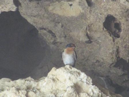
bees ceased. A Welcome Swallow put on a flying display for us. Then I spotted
two more on a ledge near their nest.


A
little way in – looking back at the entrance.

We
had taken two torches and we needed them. It was pitch black as we rounded the
corner and lost the sunshine from the entrance.
I took a few shots using the flash and using the torch to illuminate things. It was very grey and the floor was sand. We found a tunnel off to the side that others have explored but we just took photos!!


Mainly the cave was open and high except for these two hanging bits. Someone had put a reflector on one which was handy.


Couldn’t
see too far ahead but it was easy walking and we didn’t hear or see any bats or
other animals.

The
cave is 300m long and the other end has a bigger opening.

Looking
back into the cave.

We
climbed down over the big boulders to the sandy creek again.


A
western blue-tongue lizard wasn’t happy to see us.


The
next cave has been closed off now though the brochure said there were two
shorter caves for the more adventurous before reaching the final cave which has
no exit. Obviously that is where the creek would have gone undergrown on its
way to the coast.


More
bee hives.


Walked
up to the northern car park which showed the flood height in 1999. It would
have been amazing to see that much water thundering through the cave.

Some
more info.

Back
down to the creek and we decided to go back through the tunnel rather than the
bush walk – no flies in the tunnel. Steve resorted to a twig as they were so
annoying. I spotted a falcon of some sort fly off with something in its talons
and then we spotted another one sitting on a branch looking very regal.


Interesting
holes in the rocks as we climb back into the cavern.


Steve
showing how big this entrance is.

Back
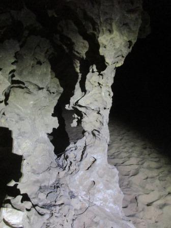
inside I tried to photograph the only column we found.
Back
to the truck and into Green Head. Had lunch overlooking Dynamite Bay – not sure
why it is called that. The sun is shining but the wind is strong and cold. Such
a change from the hot walk we just did to the caves!!
Walked up to the lookout. Great view over the bay.

Looking north to Point Louise and Anchorage Bay.


Looking east over the township then south to South Bay – original name! Further along the coast to Sandy Cape.


Called
into the Caravan Park to see Trish and Claude who are working here for a while.
Will catch up with them again somewhere.
Great
sunset photo on the wall - it is Lipfert Island in Billy Goat Bay, just south
of where we left the van.

Back
to the van but we kept driving down the track to check out the rest of the
coast. Big white sand dunes are sending fine sand into the air – and probably
into the van as I left the top vents open.

Turned
off the track to the beach where the sign said this is Milligan Island with
Lipfert Island a bit north of it. Will check it out on the way back for a photo
through the window.


Went
to the end of the track. Looking back over Anchorage Bay to Green Head and
around to Point Louise. It is nearly becoming an island.


Continued
back along the track to another little bay.


Back
to Lipfert Island to get my photo. No sunset – just a wave breaking.


Walked
down to the water’s edge – looking south then north of Billy Goat Bay.


A
lower view through the rock window.


Hooked
up the van and headed south again. Turned off and climbed a hill to Grigson’s
Lookout. Good map showing where we have been and heading to.

Interesting
information.


Great
photo of the Stockyard Creek flowing through the tunnel.

Followed
the track up to the lookout. Steve added another rock to the cairn then we read
it was actually a historic one.


Looking
north-east over the salt lake and Grigson’s Farm.


Looking
south-east over Cockleshell Gully and Mt Leseur.


Looking
south-west over the gypsum mine and sand dunes. (So annoying how it turns my photos around!!)


Finally
north-west over Fisherman Island where the seals breed. Bit hard to zoom in on
with the sun heading down.


Continued
south to nearly Jurien Bay then we turned east to find the new 72 hour free
camp spot at Wandoo Reserve. Up and down the rolling dunes and then back into
cattle pastures. The camp spot is a picnic area just off the road so not a
place we would leave the van alone but fine for overnight. Another motorhome
was here so we found a spot and parked up.

A
couple of kookaburras were having a great laugh. I think it is a baby as the
parent came and helped it along with its laughing. So nice to hear their
laughter – reminds me of home.


Rang
Julie and Bruce to make sure they will be home tomorrow when we go into Jurien
Bay. Julie said to come stay which will be nice.
Quiet
arvo doing my blog listening to all the birds – no wind. No TV reception
either!!


