7am
15 degrees and overcast. Jon rang to ask Steve about a job. He had sent a photo
of Dan with a kitten. It was a stray caught in a trap over the road and just
left to die. The boys rescued it and then took it to RSPCA. It was quite tame
but Dan doesn’t want pets!!
Headed
off again. Over the crest of a hill we could see the huge tailings piles of the
Princess Royal Mine. A lot hillier country here. Jimberlana Hill at 399m
elevation.


Stopped
at the Norseman Info boards before town. Chatted with a couple who have No
Warranty & No Service on the back of their van – not happy Jan!! Good info
and maps on the boards.


Into
Norseman then around to the Golf Course for 2 holes. First one Steve got 10 and
I got 15.


The
second was much better as we both got 7 – maybe we should have been playing
each hole a few times and taking the best score!!


I
landed beside a hole which I think is a spider hole – hate to see the spider if
he can dig that size hole.

Nice
drive through the tree-lined streets to the Info Centre to collect our
certificate for completing the Eyre Highway.


Some
great photos – Laurie Sinclair’s horse found the first gold when he got a
nugget stuck in his shoe. Chatted with the lady about the Dundas Coach Road
trail and the Gemfields. ‘Willy’ and his wife walked in so chatted with them
for a bit.


Down
the road was a statue to ‘Norseman’, Laurie’s horse.


Steve
headed off to the Mines Dept to get his prospector’s licence and I wandered up
to the Museum. Chatted with the lady and a couple about the downturn in jobs
and the effect the Fly in Fly out workers have had on all the little towns.
Lots of history in here. Laurie and his horse, Norseman. Laurie, his brothers
and a friend came north from Esperance to search for gold around Coolgardie.
Although gold had been found at Dundas, some 25kms south of Norseman in 1892,
not much prospecting had taken place between there and the major find in
Coolgardie. Laurie had decided to go back to Esperance but on the way stopped
to search along the ridge of the hills just above the current townsite. Legend
has it that whilst tethered his horse, Norseman, pawed the ground causing a
piece of gold bearing quartz to lodge in his hoof. The find was lodged as the
“Norseman Reward” which Laurie worked for a while then eventually sold it to a
large mining operation and it went on to be one of the richest reefs ever mined
in Australia.


This
significant find brought many people and the town of Norseman was established
in 1894. Between 1910-1913 Norseman enjoyed a period of great prosperity, with
a population of around 2500. In 1935 the then major mining company provided the
funds for an extension of the C.Y. O’Connor water pipeline from Coolgardie to
Norseman which made life a lot easier. Over the years the population has
fluctuated, influenced by war, depression, changes with new gold discoveries
and closures of mines etc.
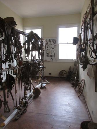
Each
room held different items.


A
lot of miners used dry blowers around here.

At
3.22am on the 23rd March, 1977 the Norseman Court House building was
completely demolished by a violent explosion, perpetrated by a person or
persons unknown (obviously someone wasn’t happy with the Judge’s decision). It
has since been rebuilt. A few items were given to the museum like the Witness
box, clock etc. The thing hanging on the wall is the remains of a typewriter
that was sent flying and landed on a building nearby.


Saddles
and tools then household furniture etc.

The
school and hospital.

Bikes
and appliances.

The
kitchen. I told the lady about wanting an old egg beater as there was one here
too.


Back
to Steve and we walked down to check out the Camels on the roundabout.


Drove
up to Mines Road to Beacon Hill Lookout passed the Pheonix tailings storage
facility (40m high, 4 million tonnes over 12 hectares). It looks like a pyramid
with the top knocked off. It was built between 1935 and 1977, from tailings
from the Phoenix mill. The original shaft is directly under the current mill.


They
are still working here.


We
had to stop as a big truck carted dirt from the mine site on our right to the
plant here.


Passed
a pull off area then followed the road up and around the hill to the top to the
communication towers and the lookout (423m elevation). Made some lunch then
read all the info. Bit chilly up here.


2001
it was growing but now it is declining. There are lots of shops closed and
houses for sale. Gavin said you can buy a house here for $20,000 though looking
at the houses that is all they are worth!! Only found one house that is ‘nice’.

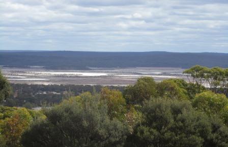
Unfortunately
the trees have grown so their 360 degree view the brochure says isn’t quite
true but it is still a good view over Lake Cowan. It extends about 6.5km south
of Norseman and continues north as far as Widgemooltha – about 120km. In the
early mining days water was drained from trenches dug on the lake edge and then
condensed for use in the mines. The groundwater around Norseman is also
hyper-saline and is up to 9 times saltier than sea water. The lake is currently
mined for gypsum which is used in gyprock ceilings, underground support pillars
in mining, plaster of paris and as an additive to cement rendering. The gypsum
works is about 5km from town in a south-west direction. An aerodrome is also
situated on the lake, making use of the large expanse of flat land. It is used
predominantly for the Flying Doctor Service.


A
cairn marks the original gold mines etc.


A
board highlighting the things to look at – through the trees!!


Historic
Butterfly Tailings Dump. They stopped using it in 1986, 25m high, 2.48 mil
tonnes over 25ha).

Looking
across the other side of the hill to Lake Brazier and around to the Hit and
Miss Mine. The lakes only hold water after heavy rain. The mine was originally
mined by Australian Gold Mines NL in the late 1980s and was reworked by Central
Norseman Gold Ltd in 1998/99. The mine generated 277,000 BCM of waste rock
which was deposited in two dumps located either side of the pit. These dumps
total 12.55 ha in area and reach 10 metres in height.


Headed
back down looking over where they are mining. Scooping up the rock which goes
through the ‘red’ crusher and then the finer material taken over to the mill to
process using a gravity separation process to recover the free gold. The
remaining crushed product is screened and the coarse material is ground further
until it is a suitable size to be sent to the leaching tanks. The leaching
circuit consists of both leaching and absorption processes. The ore is mixed
with water, lime, sodium-cyanide and liquid oxygen to make a slurry which moves
by gravity through the absorption tanks. A hard, porous, activated-carbon made
from coconut shells is fed into the last leach/absorption tank which absorbs
the gold onto it surface. About 80% of the water used at the mill is recovered
from the waste-water stream for re-use.

The
Norseman Gold Belt is 80km in length and stretches 40km to the north of town
and 40km to the south. It consists of two parallel ranges of hills running
almost north-south between the lake country. Unlike the alluvial gold found in
the Coolgardie region, the gold in this region is found in very hard rock which
rarely outcrops. Some of the rising ground attains an altitude of between 150
and 180 metres and the reefs in many instances follow the surface to the
highest point. Along with gold, many other minerals have been mined and sold,
including silver, tin and iron pyrites (for the production of sulphuric acid). Rehabilitation
of historic disturbances and mine shafts in the area is an ongoing task with
old drill holes being capped and over 1800 old mine shafts varying in depth
from 4 to over 100 meters being backfilled. Pulled off into the parking area
before the Haul road to check out a sign. The Bullen Decline commenced in Sept
1991.


I
walked around the path to view the mine entrance.


Headed
back to town with the two big tailing dumps on either side of the road.


Spotted
a house with lots of old bits and pieces in his yard. Truck with trailer and
even the bowser.

Nice
mural outside the Op Shop.

Stopped
at Phoenix Park which was created as a tribute to the mining history here but
unfortunately hasn’t been maintained.


Headed
south following the old Coach Road. Stopped at the Sites to read the info
boards. First one was the Race Track.


Don’t
think the track looked this good in the old days.

The
Red, White & Blue mine has been rehabilitated.


Lonely
grave of James Dennis who died in 1895 by accident, aged 27.


Wandered
around the old mining area of the Lady Mary Mines.


These
shafts run down at an angle. Can’t imagine climbing down there.

They
continued along in a line.


Big
entrance to the Iron Duke Decline.


Amazed
how my camera could see further down then we could with our eyes.


Cuppa
at the Break O’Day cricket pitch.


Totally
missed the ball with my hunk of timber!!


This
head frame was brought here from Norseman in 1978 and used to bring up the
gold.


Peered
through the mess at the shaft below and the rail lines for the trolley to come
up on.


Beside
it was another shaft.


The
road has narrowed a lot as we pass through the Brookway Timber Reserve.

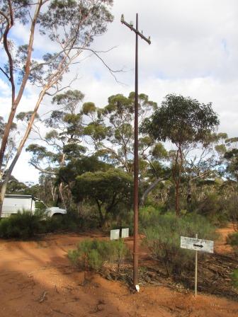
Stopped
at the intersection of the old east-west telegraph line which goes straight
across to the old Balladonia Station.


The
May Bell (1894) was the start of the Dundas Goldfields.

One
about foods in the area. I think that was a Quandong tree we saw beside the
Cocklebiddy Cave.

They
used the sloping granite rocks as a water collecting site.


All
about the Great Western Woodlands we have been travelling through.

At
the end of the trail we reach the old townsite of Dundas on the edge of Lake
Dundas – not that you can tell where the lake actually is as there is no water
in it.

A
street sign marks where the main street was.


Nothing
left except a few broken bottles and old fence posts to tell the stories of the
people who lived here.


Spotted
a couple of vans parked in the bush. Have marked it to come back when we are
heading south and explore a bit more. Continued along the track west towards
the highway. Passed more ‘lakes’.


Back
on the bitumen we quickly headed north back to Norseman. Speed cameras flash
your speed as you head into town and if you are good you get a ‘smiley’.

Into
town then we turned west again on the road to Hyden (where Wave Rock is). The
sun is dropping highlighting the Phoenix pile.

Back
onto the dirt to cross over Lake Cowan.


Passed
the Lookout and onto the Gemfields camp area. The sun is disappearing quickly.

I
wandered around while Steve found a spot for the night.


Lots
of scrapings and chunks of agate ready to pick up. The lady at the Info Centre
said she gets the council to come out and dig spots for the tourists to sieve
through.


Steve
picked a spot near some dig holes but we will check them out in the morning.
Need a fire first so we can cook in the bushcooker.


Cool
night but it is lovely by the fire.