6.30am
24 degrees, high cloud covering made a nice sunrise photo. Cool wind.

Into
Warakurna and around to the Giles Meteorological Station.


The
Outback Way info board. We are at 593m above sea level.


Explains
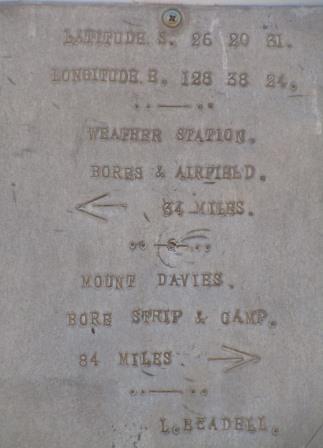
about the Schwerin Mural Crescent we passed yesterday.

Lots
of things to see and information to read in the little museum. First about the
explorer Ernest Giles and the weather station.


Articles and photos about Len Beadell and the Gunbarrel Highway Construction Party.


Some
more info I found -
A select few remained the backbone
of the Gunbarrel Road Construction Party (GRCP) for 10 years. Willy Appleton
and Eric Graefling were the handymen which role also included being the
cherrypicker – a monotonous but important job of removing stones and branches
after the grader had passed through. The cook was Paul Christensen; supply
drivers Bill Lloyd and Frank Quinn; Fitter – Rex Flatman; Grader – Walter
‘Scotty’ Boord and Bulldozer – Doug Stoneham. The grader driver, who spent many
long hours by himself was presented with the wonderful nickname of ‘Grader
Garbo’. The GRCP used 4 dozers and one grader, which now resides at Giles Weather
Station. Over the course of his exploits, Len wore out 12 Land Rovers. Of
course, there was a backroom cast of thousands: at supply depots; the Adelaide
workshops that supported Len’s Land Rovers; and the air crews.
Len
was a great artist too and painted this mural on the wall in 1958.

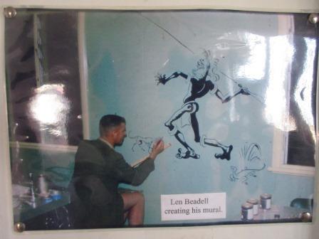

This
one depicts Bureau Technician, Phil Day, working on the WF2 Radar. This radar
was decommissioned in 1992 having been replaced by the current WF100 which is
housed inside the white dome. Len presented Phil with this painting in 1982.

A
picture in 2003 of Doug Stoneham in the grader though he drove the bulldozer
most of the time.

There
are no tours available today and we can’t see any workers around. I used to
take the weather using one of these cabinets when I worked at the Bureau of
Sugar Experiment Stations.


Outside
is the remains of the first Blue Streak Rocket launched from Woomera on 5th
June, 1964. It was discovered 50km south-east of Giles in 1980.


Also
the grader that Len’s team used to create the Gunbarrel Highway.


Found
the original plaques that Len put on the trees. Plus another one.


Watched
the weather balloon being released at 8.45am Central Time. The only do one a
day now. Still haven’t seen anyone so not sure if it is done automatically now.


The
sky has cleared so it is easy to keep watch on the balloon. It took ages to
rise even though there is a good breeze but then it hit some wind up high and
took off in another direction heading to the sun so then we lost sight of it.
We
have phone reception here and a message came through from Tom and Sandy that
they are leaving camp on Tuesday so hopefully we will get back in time to see
them before they head back to Perth.
Stopped
at the Warakurna Roadhouse. Interesting sign about unleaded fuel.

Chatted
with a couple with a camper trailer like the one we saw broken in the Simpson
Desert. They had come up via the Great Central and said it is cheaper fuel here
$2.40/l than at Warburton which was $2.60. The chap managing the roadhouse has
been here 6 months and said it wasn’t too bad. We did a drive around the dump
looking for Nissans but there were none available.
A
Beekeeper stopped for a photo. They are so cute.

As
we headed out we spotted another one of Len’s plaques by the road.


Back
to the Great Central Road again for 18km then we turned onto the abandoned
section of the Gunbarrel Highway (made during March to May 1958 then finished
it in August 1958) that went north through the Gibson Desert and down to Jackie
Junction then across to Carnegie. Len nearly died of thirst during his March
1958 reconnaissance for this section. There are restrictions on transit access
for this section – need 2 to 5 vehicles etc etc, so we can’t do it either.
Looking on the map it looks like it goes over a lot of sand dunes.


Drove
along it for a bit to a Y-junction and stopped for a cuppa under a tree. At
least we can say we did a bit of each section.

We
are on the edge of the Gibson Desert but of course there is lots of greenery
around us not just sand dunes. Back down the track to the GCR again and we
continued west.


Flat
spinifex covered plains with low sand dunes. No animals, just dead cars along
the road side. Road condition pretty good so far.
Turned
in to check out Tjulun Rockhole. There was supposed to be an info board at
Tjukurlapini Rockhole but we didn’t see any signs and it wasn’t on our Hema.


At
this point we enter WA time zone so the 11am for Central Time goes back to
9.30am for WA time but we are going to change the time later.
Thick
smoke haze as we near Yaralakutjarra Campground. Climbed up a rocky ridge. Nice
view then we turned into the campground.

Great
information sign. We were wondering who built the Great Central Road initially.
Also the Laverton Road was built by missionaries in the 1930s and the Docker
River Road was built in 1956 to access Giles Weather Station and was used in
1960s as part of the nuclear missile tests.


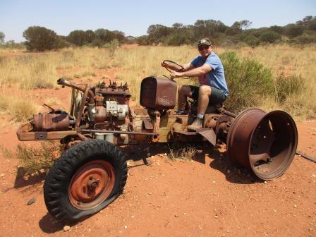
The
old tractor. Steve took it for a run!

There
is a shelter and long drop toilet.


Lots
of burnt areas exposing the red dunes then we went through a rocky outcrop
section.

Back
to flat plains and occasional sand dune.
A
4WD of locals zoomed by us flicking up rocks. One hit the windscreen but we
can’t see any damage. Steve said he had only thought about how well we have done
since putting in the new windscreen. Mind you we normally get the chips from
rocks flicked up off bitumen.
A
few more cars heading east then four guys on motorbikes. A couple were standing
– not enjoying the corrugations I bet.
Into
Warburton Roadhouse which is on one side of the road and the Community is on
the other side well back from the road. Signs at the bowsers about ‘no
photography’ again and about locking up our unleaded fuel again. Checked the
diesel price and it was only $2.35/l – don’t know what happened there as the
other couple said it was $2.60. We topped up the tank any case.
We
made some lunch and sat under the shade shelter nearby. Watched the ‘locals’
zoom in and out of the roadhouse – so much for the speed bumps. A car zoomed in
and got a wheel out of the boot which they pumped up then they took off again.
There is a high fence around the roadhouse compound with razor wire along the
top. They have accommodation in there and a campground and we can hear some
peacocks calling.
There
is an art gallery but we just checked out the Outback Way information board.


We
continued along the nice smooth bitumen when we saw something in the middle of
the road. There were bits and pieces scattered along the road but then we saw
people walking around.


It
turned out to be the guys we saw pumping up their tyre. They had a front tyre
blow out and it disintegrated along the road taking out their front bumper. We
pulled up and one chap asked if we had an air compressor. Steve pulled over in
front of them and got out to help. I was jotting down some notes in my diary
then realised I should go back there and keep an eye on things, just in case.
The spare they had pumped up actually had a hole in it. Steve tried patching it
with plugs but it was too big and when he blew it up the plugs would pop out.
He ended up putting in glue and the plugs and managed to get it pumped up. I
chatted with the guys about what they did. Rounded up camels to sell overseas
as breeders. I asked how many people in Warburton and he said about 180 as most
were in jail! I said I had met one chap at Kookynie that was heading back to
Warburton with his wife and child after getting out of jail and he said that he
just arrived back. I didn’t have the heart to tell him that was back in February!!
As one chap put the tyre back on, another put the bumper in the boot. The rim
and ripped tyre were rolled down into the table drain. I said ‘hey, what about
looking after Country’ and he laughed and said ‘that ok’. Really!! They were
looking for a lighter so I ended up giving them a box of matches. Funny as it
is their belief ‘all to share’ but on our ‘permits’ it says if we require any
assistance from Communities etc we will have to pay. These guys were very
grateful and said thanks which was nice.
Continued
along a very long stretch of bitumen. Rolling over low sand ridges that are
close together then back into spinifex plains and small shrubs.

The
bitumen ended at the turn off to the Heather Highway – not sure who this was
named after and if it was one of Len’s. The wind is still blowing hard.


Up
and down ironstone ridges with lots of trees in the gullies on a straight track.

Spotted
a herd of camels in the distance. So far we have only seen 1 hawk and two
goannas today.
Turned
off the straight road which goes to another Community and continued on the
Heather Highway along the top of a ridge on a narrow track – lots of
corrugations.


Dropped down to open flats with ironstone gravel – more corrugations.


Spotted
10 more camels - they obviously have lots to choose from when they want to sell
some more to the Arabs. Stopped to check out a broken trailer.

Lots
of bypass tracks around some eroded spots and corrugated stretches as we climb
gently up and down wide ridges.

Reached
the Gunbarrel Highway again where there was another dead trailer. Looking east
then west.


We
drove west to check out a lookout. Track narrows so truck getting a scratching
from the trees.

Quite
a rocky track so slow going. A lot of the original track has been eroded away.
Only problem with a straight track is the water just flows straight down it
taking away the top soil.
Up
to the top of Mt Samuel (520m) where a huge rock cairn was. Steve added a rock
to the cairn.


The
wind was whistling up the slope nearly blowing me off my feet. I took a video of
the view after our selfie. Forgot to take more still photos of the view but it
mostly just green shrubs & treetops.

It
is 4.16pm so we decided we could wind the clock back an hour so it is only 3.16
so it is time for a cuppa. Another half hour to real WA time but we can do that
later and hopefully not be too affected by going back in time!
Back
to the turn off taking photos of the eroded sections as we go.


Continued
west on a narrow track – getting a few pin stripes on the truck as we go. Not
as bad as the Canning Stock Route though. Spending a lot of time on the detours
as the original track is so eroded. Video of one original track section that
didn’t have a bypass track.

Found
the next Len Beadell plaque in a big gum tree.


There
was sign for water 400m down a track. He had a hand pump with a bucket. Steve
got some water out for the birds and animals – took a video. Cool and not too
salty.


Onto
red sand track now. Lots of camel tracks and dung.
Continued
through spinifex and shrubs with a group of sand hills.
Onto
open plains with long sand ridges covered in spinifex. Our ‘zoom zoom’ birds
are back racing us along the track.
The
track became very sandy and corrugated.

Stopped
to check out another hand pump – my turn. There used to be a windmill and bore
beside it.


Continued
on sandy spinifex-lined track.
Change
to ironstone gravel again.
Climbed
a ridge to Notabillis Hill where there is a cairn. Steve tossed his rock up and
amazingly it stayed on the top.

Three
photos of the view from where we have been and one of one where we are headed.


Climbing
up and down long ridges with lots of bypass tracks to choose from trying to
avoid the corrugations. Sometimes we choose well, other times we don’t and
bounce along. Some section open spinifex and others between the trees.

Mr
Camel wanted the whole road but eventually he decided we could pass.


Through
a rock-based section which was slow going.
Arrived
at Camp Beadell at 6pm so wound the clock back another half hour so we are now
officially on WA time at 5.30pm and it is time for a drink!
There
is a bore hole here but no hand pump.


Set
up camp nearby where someone had left some firewood and a fireplace. Got the
fire going and enjoyed our drinks by the fire as there is a lovely cool breeze
blowing.

Our route for today.

7pm 27 degrees. Had dinner by the fire then played cards by the fire as the temperature has dropped quickly to 21 degrees. Last night we were hot and tonight we want the warmth of the fire.
Wind
picked up so we gave up on the cards and read our books while we had our
coffees.
The
cold wind is coming in the bed side so I closed the door and we were all good.
Very quiet here except for the whispering desert oaks.