7am
the wind is back but at least there aren’t many flies. Dark clouds coming over
from the west.
Packed
up and continued along the French Line, across another salt pan then back into
the wobbly low dunes.
More
gypcrete coming to the surface.


Dark
cloud ahead of us.

Lots
of ‘tumbleweeds’ along the track.

Still
wobbling through the low dunes.
Met
a car of young chaps who stopped for a chat. Steve commented about the track
heading east and they said it has been so chopped up so far. We said ‘yes we
got the better track this time’.


The
track continues.

Spinifex
returns on the flats.

That
dark cloud went south thank goodness. Crossed over a few bigger dunes.

Spotted
a one and half metre snake on the track so we stopped but didn’t get out of
course. It wasn’t worried about us, just kept on picking up ants and bugs then
turned into the grass but came back out again and wiggled its way away from the
track. Took a video of it – it was fascinating to watch how it moved along.


Turned
off onto Knolls Track. Stopped and checked out the plaque for David Lindsay.
Someone made a rock cairn balance on the tree branch.


Followed
the rutted out and bumpy track due to the gypcrete lumps. There are lots of
detour tracks to choose from. Lake Tamblyn appears first.

Lake Tamblyn
This was named by Ted Colson during his crossing of
the Simpson Desert in 1936. The lake was named after John Tamblyn, a friend of
Colson’s who worked for the SA Education Department.
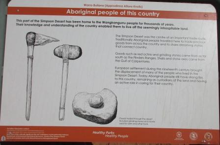
Onto
Approdinna Attora Knolls. Read the info sign beside the fence around the first
one.

Continued
along past the second one then turned into the car park. Lots of gypsum lying
on the ground in the car park making it very sparkly.

Six
information boards to read as we head up the path to the Knoll.


The
information in the National Park brochure said they appear, almost ghost-like,
from amongst the red sand dunes. Well I don’t think that really fits. To me
they looked like mounds of gypcrete as the shiny gypsum seems to be mainly on
the flat around the mounds – but I am no scientist!!

Nice
view from the top though over truck and around to Lake Tamblyn.


I walked
to the northern end of the knoll to photograph the other one then across the
land to the east.


No
shiny gypsum up here.

Someone
has a home in there.

Back
to the bottom and we checked out the shiny gypsum on the flats. Steve found a
big piece that shone in the sunlight and broke in half easily on one of the
layers.


Had
a cuppa in the car park. Nice breeze blowing so it doesn’t feel hot.
Went
back out to the French Line and continued along to the northern end of Lake
Tamblyn. There are islands in the middle which we just drive over. Lots of
tracks and circles done by other travellers.


Another
lake further along with more doughnuts on it.
Continued
rolling over the lower dunes which are covered in dry grass clumps and green
bushes. No big trees in this section.
Over
a bigger dune and we spotted the broken Range Rover we heard about in
Birdsville. They are trying to get parts so they can get it going again. Not a
nice experience for them. They have a broken window and had put a sign on the
window to let travellers know they were ok.


Up
another big dune then back to the low rolly polly ones.
Over
a few big dunes then across a wide flood plain with bigger trees again.
Every
5km there is a white post with FRN and a number which is the distance from
Dalhousie Springs – this one is 201.
Just
rolling along slowly in 1st and 2nd gear doing between 10
and 15kph.
Sky
all clear now. Bigger dune with two tracks so bored Steve decided to take the
straight left one. I took a video. At the top there was an eaten away hole on
the right so he stopped quickly before we fell into it. Backed up a little and
turned away from the hole with a few more herbs and we were fine to continue.
If we had done that on the CSR dunes we would have been stuck as the sand seemed
a lot softer at the top of those dunes. His ‘I didn’t have a 2nd go
at a dune’ record is still standing for this trip so far. We noticed lots of
back up on the western side by other travellers.

First
gear is revving too much and second gear doesn’t quite have it for all the
wobbly bits so he put it into low 4WD and is using 3rd gear most of
the time now with 2nd for the steeper climbs.
Got
a photo of one of the eaten out holes on the top of another dune – doesn’t look
as bad as the other one was. The grass holds the sand but the wind has whipped
the rest of the sand from the bottom of it and you come up and lean straight
into the hole. I don’t like that feeling!

Nice
view from the crest of a dune of more smaller dunes then a big one in the
distance.


Stopped
to check out the wrecked camper trailer – another sad holiday story. Looks like
it will be an ornament of the desert now as they aren’t coming back to retrieve
it. They were heading west too but it looks like the chassis snapped behind the
suspension arms which ripped the bolts out of the front and the camper slide
backwards. Bit of a mess. They obviously took what they could. I closed the big
doors to stop more of their rubbish flying around the dunes as some has already
done.


I
walked up the dune to take a photo of our truck and the track we have been
over. Looks quite green further south – just all the green bushes.


Continued
on and found an open area to have lunch. Parked by a shrubby bush to give us
some wind protection as it is blowing well at the moment. No flies here either
so we enjoyed eating our lunch. 29 degrees in the shade.
More
up and down the lower dunes with no big trees in sight. No animals either other
than the tracks they have left.
Wide
flat section between two bigger dunes where there is a Bench Mark with a tap
and water sign. I was intrigued and turned it on – of course no water!! Where’s
the hidden camera.

Saw
a little grasswren run across the track to a bush – they are so cute.
Videoed
the climb down one of the bigger dunes as it was quite bumpy and then across
the wide flat section and then up the other dune. Steve happier now we have
left the little dunes behind.

Up
and down more bigger dunes. As we crossed one flat section it was covered in
yellow blossomed trees. Only spot we have seen them so far.


Came
to a Y choice track so Steve took the right one – it was 20 metres high
according to our Hema. 55m elevation at the bottom and up to 75m at the top. We
then went onto a plateau for a while going over smaller dunes then we wobbled
our way down the west side to then climb up another bigger dune.

Across
the intersection of Erabena Track. 8km to the north is an old field according
to the map – not sure if it is still functioning but the track is in good
condition. The Rig Track had base put down on the top of the dunes so machinery
could traverse them easily when the oil exploring was going on.
Up
and down more big dunes. Steeper this side but not chopped up like the west
side due to all the traffic it gets – so we have a bumpy ride down.

Another
nice dune photo.

A
small goanna ran across the track but didn’t stay around for a photo.
Still
bigger dunes and flatter sections between them. Spotted some camel dung on the
track and footprints but still haven’t seen any camels other than the 3 that
visited us that night in Eyre Creek.
The
dunes are getting higher – one was 22 metres but most are between 12 and 16
metres. Steve having fun climbing the bigger dunes and ‘Pat’ is doing it with
ease.
Stopped
for a cuppa between two dunes and Steve found a pair of magnifying glasses on
the track – still in good nick too. Still quite windy. Thermometer says it is
34 degrees in the sun.
Continued
on up and down the bigger dunes. Some are a bit bumpier going up and a few have
angled approaches now rather than straight up and over. Some people have made
their own tracks.

Got
excited when a little wren flew along the track in front of us – no much life
out here so it is nice to see something flying about.
The
track continues – very rutted descent.


More
steep ascents and angled ones but we are all good. Noticed the people ahead of
us have had a couple of back-ups to get up these ones. Plenty of backing up on
the west side approaches.
Crested
one dune and we are at the highest point so far – 90 metres above sea level.
Nearing
the Colson Track turn off so found a spot to camp for the night.
Our
route for today.

A
few more flies here which was annoying while I was writing my blog.
Walked
up the dune beside us for a photo of camp.

Light
breeze but not as bad as last night so haven’t need to put up the awning and
wind break.
The
wind stopped completely so we had our showers in case the wind started up
again. So lovely under the stars.
No
noises at all out here – not even animals scurrying around, except for the bugs
that are buzzing around our light as we played cards since the wind never
returned.
Quite
cool by the time we went to bed. So eerily quiet.
No comments:
Post a Comment