Should
have put up the mozzie net as they bugged me all night. A dingo howled in the
paddock near us and he slowly worked his way across. Mr Rooster started at 4am
so hence I didn’t get a good night sleep.
6am
19 degrees, fresh south easterly breeze, clear sky.
Fascinating
watching the other campers pack up. I was watching a chap with huge suitcases
trying to fit them in the back of his 4WD. He looked over and I commented that
I am amazed how he fitted it all in. He said he had it on the roof rack but it
cracked under the weight as they were coming across the Great Central. Steve
offered to see if he could fix it but it needed more that nuts and bolts that
Steve had. The couple and their three children were from the Netherlands and
were travelling the world. They started in Russia and had driven through a lot
of countries before coming to Perth. They bought the 4WD there and are doing
the diagonal drive across Australia to Cairns. The kids were loving the travel
and think Australia is great.
We
packed up and continued west along the bitumen through desert oaks and
spinifex. This is part of the Longest Shortcut – Laverton to Cairns. They hope
to have it sealed by 2025 and will provide diagonal access across Australia.
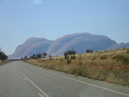
50
kilometres later we got our first glimpse of Ayres Rock.

Further
on was another great view of Ayres Rock and the Olgas this time.


Turned
into Ayres Rock Resort and Yulara for a cuppa by a nice big desert oak.

Walked
up a sand dune to Imalung Lookout. We are at 520m elevation here and it is
quite windy.

Great
view from here. Zoomed in then panned around. Took a video too as you can see
the Olgas from here too.


Checked
out the Town Square and found Steve’s café. Nice Kangaroo Paw.


Chatted
with a guy about stars etc as they have astronomy tours etc.

Continued
along and stopped at the National Parks fee station. We didn’t have to pay as
we had our Central Lands Council permit to travel the land to WA border. Turned
off to head west instead of into the Ayres Rock area – nice photo from here.

242km
to the WA border.
Stopped
at the sunset viewing platform for the Olgas. Lots of information too.


Last
look back to Ayres Rock.

Another
15km to the turn off into the Olgas but we continued on towards WA. A view of
the other side of the Olgas.
Still
bitumen for a bit then a long roadworks detour.


Onto
corrugated road of the Longest Shortcut. Thinking of Bob and Margaret when they
towed their van over this.

Long
stretch of burnt area exposing the dunes.


Passed
a dead car by the road. Pulled over into an area of desert oaks to have
lunch. 37 degrees in the shade – hot dry
wind.
Continued on – not long till we find another dead car on the road this time with smashed side window.


Wind
whipping up the sand from the burnt ground. Dust storm ahead.

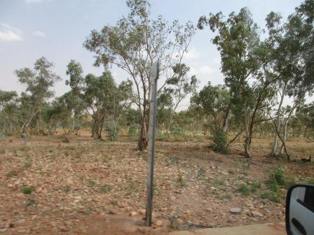
Into
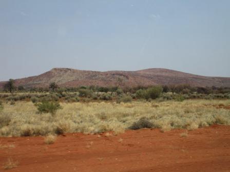
spinifex covered ground and bigger trees here and there.
Along
a low range to the south.
More
dead cars off the road – plenty of bumpers, ripped tyres, rims and mufflers. Across
a wide dry Muwa River as the Peterman Range comes into view.
Across
Puta-Puta Creek and past two houses and windmill, maybe an outstation.
Mt
Miller (904m) is nearby according to the Heam – That’s Steve’s Mum’s maiden
name.
We
have climbed to 680m now. Mountains continue but called Cordie Range now.
Old
round stock yards as we enter the turn off to Lasseter’s Cave. There are two
more houses here and a water tank. Hot dry wind still blowing – very nice being
in our air-conditioning.
Read
the info, we are now at 639m elevation.


Only
a short walk to the cave.


Had
a cuppa then Steve washed his hands at the water tank. There was a bowl so he
filled it for the birds who quickly flew down to have a drink.

Had
a few cars pass us heading east. Smoke spiralling in three spots ahead of us.

Burnt
and unburnt country.


The
range continues to our left. Majestic looking mountain but no name on the map.

Three
camels were by the road then as we approached decided they wanted to be on the
other side!!


Another
range appearing ahead and to our right.
Onto
bitumen for 5 km before we reach Docker River. Lots of horses and a cute colt
as we pass the airport.
Across
a wide dry Docker River.
Houses
scattered throughout the trees are part of the Community here.
Turned
off into the Community, no photography allowed – fairly neat though they have
the usual ‘junk’ in the yards. Nice murals on the shop and the school stadium.
We were going to top up the fuel but it looked a bit abandoned and the fuel
bowsers were locked up tight. Drove around the rubbish dump looking for any
Nissans in case we can pick up a fuel tank. Mostly Ford and Holdens with a
couple of Toyotas.
Continued
on westward through a long section of road works. High mountains on each side –
quite impressive with the valleys running down their sides.

Roadworks
detour track crossed into WA so we didn’t get to do the border photo as the
sign and info about the road ahead is on the road being resurfaced. I zoomed in
on the border sign and all the roads are open so we are good to go on.

We
aren’t worrying about changing the clocks as Giles Weather Station and
Warakurna are on NT time.
The
ranges continue on each side of us but we are travelling through a large flat
plain in between. Clouds are coming over.


Passed
the turn off north for another of Len Beadell’s roads, Sandy Blight Road.
Further
along we spotted one of Len’s plaques in a big gum tree. Obviously there were
no big gums at the intersection so he put it further along this track. This
plaque is a replica made by his daughter. I suppose people will steal them a
souvenirs! Still very windy.


Continued
on to another marker which is for this range of hills.

Big
hills disappear north and south as we roll over low ridges. Another abandoned
car on the road. We approached it carefully as we thought there was someone in
it but it was the headrest – never know what we might find.


Across
a very sandy Giles River. More dead cars and car parts along the road. So much
for looking after ‘Country’.
We
turned off the main road to head down to the Giles Mulga Park Road intersection
as the Great Central bypasses it here. Found another of Len’s plaques for the
second section of the Gunbarrel Highway.


Further
along we found the good gravel road that would take us down to the Surveyor
General’s Corner. If we had continued south from Mulga Park Station into SA we
would have come out here.

Here’s
a map of the corner and road.

I
downloaded a picture of the Corner peg since we decided not to spend the $150
to the Aboriginal Community to drive down there.


Some
info I downloaded -
Surveyor
Generals Corner (WA/SA/NT)
“The most remote of the corners, this desert location has an unexpected
(and literal) twist. Though the WA border had a simple definition – the 129th
east degree of longitude – it wasn't until 1922 that this was formalised as a
line running north-south from two anchor obelisks. Unfortunately, it was only
realised decades later that these markers were out of kilter, their surveyed
lines missing each other by 127 metres.
Oops. So in 1968 two monuments were set up at the resulting right-angles
where the WA border does a brief east-west zig-zag in the desert. The
easternmost corner, where two states and a territory meet, was named
Surveyor-Generals Corner after the three officials who attended the ceremony.
Though it's impossible to verify, it's often said
that this remote point has been visited by fewer people than those who've
visited the South Pole. As the corner falls within the traditional lands of the
Irrunytju community, access is limited to guided tours which can be arranged by
negotiation.”
Joined
the Great Central Road again. There was a ‘camp’ marked on Wikicamps called
Camel Last Resort so we decided to make that our camp for tonight. It was a
quarry area but further along the track we found a spot behind the acacia trees
to give us some protection from the wind which is still blowing well.

The
water in the back tanks was nice and hot so we had early showers then had our
drinks as the sun started to set. There are big dark clouds passing over us –
hope they keep moving!
I
worked on my blog – the flies found me!! Steve continued with his book. This is
our route for today.


Still
a hot dry wind but we are protected by the trees. Beautiful sunset.


Will
have to get this one printed for the van.

A
couple more before it disappeared.


The
wind settled to a nice breeze as we climbed into bed.
No comments:
Post a Comment