Benjamin’s
birthday but no service to send him a message. Hope he has a great day.
Wind
picked up at 2am then pitter patter of rain at 3.20am. We got out and pulled
out the awning to protect the boxes and by the time we had the rain had
stopped. There was a couple of rolls of thunder and some lightning. Nothing got
too wet as the wind was so strong it blew the rain over us. Still 26 degrees
but the wind is cooler now.
The
wind stopped. 6.30am 25 degrees, clear sky except for a cloud band on the
horizon. I walked down to the creek.


Bit
of sunshine coming over the cloud and shining on the creek.

Flies
are back and the ground is still covered in ants. Nice little breeze has come
up now.
Packed
up and headed back to the main road via a track through more gibber stone
covered plains.

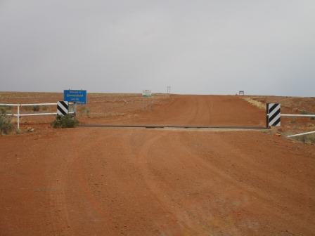
16km
till we reach the SA/Qld border. Flat country with a red sand dune to our
right. Not the smoothest road past Shale Gas Project. This area is part of the
Sturt Stony Desert.
Across
the grid into Nappa Merrie Station where the fence is presumably used as the
border fence between SA and Qld. Looking north towards Oontoo & Cooper
Creek then south.


Oontoo
In 1887 a Customs House was built and Border Custom
Taxes collected. A school, hotel and several houses were also built. In 1901
the hotel burned down and by 1903, following Federation, customs duties were
abolished and the township rapidly declined.
The
actual state border is further on where the bitumen starts for the Adventure
Way. The border marker sign is missing but we can see it on the Hema.


The Border Marker
This accurately shows the position of the border. Note
that the border cattle grid is some considerable distance further west of the
true border position marked by the old vermin proof fence. The most likely
reason for this discrepancy is that the Kidman Pastoral Company had an existing
fence in this location.
Passed
two Qld emus.

All
flat except for Saint Ann Range in the distance to the west. Green trees in
Cooper Creek.

Cattle
wandering across the road. Across the bridge, near Conrick’s Crossing, over
Cooper Creek – we can see some water upstream. Then looking downstream.


Turned
off onto dirt track to check out Burke & Wills’ Dig Tree. Four road trains
were coming down from Arrabury Station with drilling equipment and lots of bags
of samples by the looks of it.
Drove
into the Dig Tree compound and camping area which is on Nappa Merrie Station.
Nappa Merrie Station
Only 10 years after Burke & Wills travelled
through this region, John Conrick and his 5 companions, who were all under 21,
drove over 1000 head of cattle from Warrnambool, Vic and took up the original
‘Nappie Merrie’ holding. John Conrick selected the site for the homestead at
the Waterhole in 1873 and gradually enlarged the holding to its present size of
approx. 7,680 sq km.
Parked
at the Dig Tree area and checked out the information there.


The Dig Tree
The Dig Tree is one of the most famous icons of
Australian exploration. This is the site of the forward base from which Burke,
Wills, Gray and King made their dash to the Gulf of Carpentaria and the point
where they believed safety would be found upon their return. The group waiting
for their return thought Burke’s party had died and left for the Darling River
only a short time before Burke returned. Burke and Wills died near Innamincka.
Gray had previously died near Coongie Lakes and King was cared for by
Aborigines until found by Howitt’s rescue party.
The
blazes made in 1861 have been covered now by the tree regrowing its bark.


There was one on the other side of the tree.

Walked
over to the Face Tree – great carving of Burke’s face by John Dick in 1898. Burke’s
initials are being covered up but obviously this tree’s bark hasn’t grown back
as well as the other one.


On
the other side is Dick’s and his wife’s initials.

Walked
down to the water (Bullah Bullah Waterhole) – a pretty parrot was having a
drink.


A
few of the OBT group came in for a look. We drove over to Cooper Creek for a
cuppa.

Lots
of swallows have made their nests in the tree and it was fascinating to watch
them fly in and out of the nests.


Went
back to the information hut.

Lots
of information there. Very interesting to read there is some confusion of which
is the DIG tree that Burke did as another chap wrote DIG on a tree to the year
after when they were looking for Burke & Wills’ bodies.


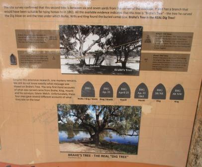


There
was a Commission of Enquiry which interesting to read. King’s version and Brahe’s,
who was the chap left behind at the Dig Tree camp that left just before Burke
& Wills came back.


Lots
of other information too about weddings and the Face Tree.


More
information about each of the explorers. Sad to think that Gray’s family were
forgotten about and his contribution has been neglected.


The
ones who were left at Depot Camp.


Well
that explains everything so we went back to the Trees to take more photos now
we know which tree is which. Both the trees with the actual DIG tree on the right
according to the info in the shelter.


The
two Dig Trees with the Face tree further to the right.

Back
out to the main road where we turned north to head up along the border to
Arrabury Station.

Past
the turn off to Innamincka No. 1 Bore.
Geologist Dr Reg Sprigg
first recognised the land formation now known as the Innamincka Dome as a
possible exploration site for oil. This was the first exploratory bore in the
Cooper Basin and was drilled in 28th April, 1959. The traces of
hydrocarbons found gave an indication of the presence of oil or gas in the
area.
Through
Saint Ann Range, rolling up and down rocky rises. No trees except in the
gullies. Amazing to imagine Burke & co and drovers etc traversing this
country back then.


Climbed
up over a hill and onto a plateau of flat, grass covered, plains for a while
then into red dirt and scrubby trees. We are following a few of the OBT.


Spinifex
appears as we run parallel with a red sand ridge.

Crossed
a grid into the Shire of Barcoo, Heart of the Channel Country, just before a
creek so we pulled off and drove along the dry creek to where we spotted some
water in a lagoon. The pastoralist has a pump and tank on the other side of the
bank. We found a shady tree and had lunch. Not as hot today with the cloud cover.


The
sky is very dark to the west.
Further
along we turned west for 4km to the SA/Qld border – there are two fences here.
Arrabury Station homestead is just inside the Qld border down a track from
here.


This
track heads back to Innamincka but we turned off to head north to Cordillo
Downs where the largest wool shed is. A rocky rough track. Burnt remains of a
ute with fridge in the back.

Passed
some good looking cows and calves by the track. Two cuties having a rest.

Some
interesting sand hills popping out of the gibber stones. A few drops of rain on
the windscreen from the edge of those black clouds.


Two
guys were coming out through the gate as we approached so they let us through.
One guy asked which way we were going as others had just come down the track
from Birdsville and Cadelga and they said the track was very rough.
Pulled
up in front of the old shearing shed.

Cordillo Downs
Cordillo Downs was taken up in 1878 and stocked with
10,000 sheep by 1883. At the turn of the century when Cordillo was amalgamated
with Cadelga and Haddon Downs, the properties were running 85,000 sheep on
7,800 sq km. Cordillo Downs is still a strong and viable property running about
6 to 7,000 cattle. It is home to Australia’s largest shearing shed.
As
we were reading the information boards we heard some thunder then the wind
picked up. I noticed a wall of dust coming towards us.


We
jumped back into the truck as the wind then rain rushed over us. Not heavy rain.

Eventually
we wandered over to the wool shed then another blast hit us. Hid behind one end
of the shed till it passed.


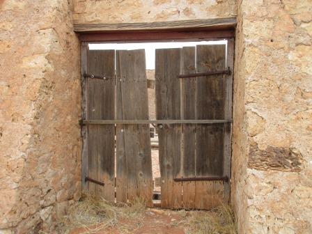
Walked
around the building peering inside. Interesting looking buildings for the
station. Lots of old machinery too.


Back
to the truck as another storm hit us. The rain has wet the shed’s roof.

Old
sheep yards.

Headed
back out – wet dirt flicking up from the tyres but it isn’t muddy like when we
drove into Sapphire to Erica and Terry.
I
had to open and close the gate this time. Back into Qld and the main track
which is much smoother and we continued north.

More
flat open country, no trees or sand hills.

Saw
our first kangaroo for a while, a big red one. He came bounding out of Arrabury
Waterhole. We pulled off and went along the creek and stopped for a cuppa. Lots
of stripped trees and bird feathers and no water in the creek.
I
noticed a little bird nest in the tree then noticed the curling bark of the
tree and remembered seeing these on the Canning Stock Route. Dug out the info -
Minnaritchie or Red Mulga. These trees
have a distinctive red curling bark, sparse foliage and grow in creeks that cut
across stony tablelands. The wood is extremely hard and was used in the early
days for fences and buildings. The red mulga only grows in a very narrow band
of latitude across Australia and can also be seen on similar soil types north
of Oodnadatta and south of Birdsville. They are one of Australia’s rare trees.


Through
some red sand hills then we rolled up and down rises covered into rock and
grass with trees in the creek beds. To the east the land seeps up then drops
away which is what they call ‘jump ups’. Through the gaps I can see mesas and
pinnacles.
Sky
is black to the west. We turned off onto the track heading west for 15km to
Haddon Corner which is where the north east point of SA meets the Qld border. A
few drops of rain fall on the windscreen. An OBT sign as we turned and climbed
up over two sand dunes – all good in 2WD. I videoed them just in case. No
vehicles here.


More
rain drops fall as we reached the corner. Open area with a picnic table. Steve
parked by the corner post and we sat in the truck waiting for the wind and rain
to stop.
The
fence heading west towards Birdsville is called the Poeppel Line. The name recognises the work of Surveyor
Augustus Poeppel who led the survey party working on the Qld/SA border from
1878 to 1881.

Got
out and took our photos with the border marker then I signed the visitors’
book.
Haddon Corner
A survey of the SA border from the Murray northwards
to Haddon Corner commenced in 1869 but was only completed to the 29th
parallel at Cameron Corner. Ten years later it was taken on to Cooper Creek and
then about 1880 was surveyed to Haddon Corner by Augustus Poeppel. As Haddon Downs
Station was taken up for pastoralism some years earlier and was the corner
property for the State it is assumed that the corner was named after the
station.


Looking
south down the border fence line. Nasty barbed wire fence so we can’t jump the
fence into SA!! A station fence continues north which I didn’t take a photo of
so we can’t follow along the Poeppel Line.


Went
back over the dunes looking for a spot with a bit of protection as we think
there will be more rain coming. Checked out other spots but the wind has
changed direction so we went back over the dunes – Steve getting some practice
for the Simpson Desert.
Picked
a spot near the Corner and set up camp.

Our
map for today.

Luckily
we angled the truck as the wind changed direction again. Put up the wind
protector in the kitchen side and put all the boxes there in case more rain
comes. The wind picked up sending sand under the truck. Luckily most of the
sand has been blown from here so it isn’t too bad. Got out our books and a
drink and spent the afternoon reading as the wind howled around us.
Cooked
dinner and then read some more till coffee time. Had a quick wash then in
between showers darted around the other side and into bed. Door down – all
secure.
No comments:
Post a Comment