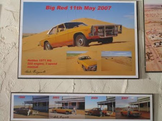
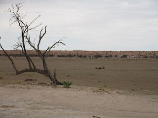
7am
cloudy and 23 degrees but there is a nice breeze.
Packed
up camp. Steve topped up the water tanks while I got some fresh fruit and vegies.
Had
a cuppa in the camp kitchen while I wrapped all the vegies in newspaper. Rang
Mum and Dad to say we will be out of phone contact but we have put credit on
the Sat Phone. Texted the boys, Erica and Brian too.
Drove
around to the service station and the chap came out saying the town has just
lost power so he can’t give us any diesel at the moment. We went around to the
Birdsville Hotel, with change for the RFDS, to take photos. The staff were
standing around listening to all the things go beep hoping the power will be
back on soon.
Dropped
my money in the RFDS tin and took some photos. The hats hanging over the bar
are in recognition of those who have been known to have done the ‘Hard Yards’
for a period of time at Birdsville and who have been invited by the owners to
display their hat.
On
the top of the wall and ceiling opposite are the hats of those who have done
the ‘Hard Yards’ in Birdsville and have since passed away.
More
photos and flags on the ceilings.
I
asked about why the Fred Brophy picture was there and she said that he has come
out here with his boxing tent for many years and still does, though he is
getting old.
I
liked this sign.
The power came back on after 15 minutes so we went back to the servo. I chatted with the
owner while Steve filled up. He grew up here and his grandfather was the
accountant for Sidney Kidman. Where is servo is located was the cattle yards in
the early days and the stockman would leave their cattle there, head into the
Hotel for a good session then continue down the Birdsville Track to Adelaide.
He said Kidman bought a station in the desert called Annandale – nothing there
now and then wanted one near Bedourie. He had to buy the pub with the land
which he did and then on sold it to this chap’s grandfather. He always told him
– “Kidman made his money by selling things at a good price – I had to pay a
fortune for that pub?”
Drove
around to the Information Centre and looked over everything again as we only
had a quick look last time.
Found
this plaque about Augustus Poeppel in a corner of another room. Interestingly
it says that he returned to resurvey the peg in 1884 where other info I have
says Larry Wells was hired to resurvey the border in January 1884 and shifted
the peg in February and that he went on to survey the NT-Qld border.
Took
photos of our next adventure off the big Hema map on the wall.
Nearly
lunch time so decided to try the Birdsville Bakery again. Much better pies this
time. They have lots of old photos on the wall. He said the chap at the servo was
a Gaffney who was a long time family of this area. We chatted about how long he
will stay open. They have owned it for 2 ½ years and last time stayed open for
the summer but it cost them too much in electricity to keep all the fridges
going. This time after having a holiday they will open one day a week, probably
Friday, to bake bread for the stations and have fun nights for all the locals
to enjoy, pizza or trivia etc.
The
sky hasn’t cleared, in fact it is getting darker as we head west towards Big Red.
Mightn’t get my sun set photos tonight.
Dirt
for a while through cream colour flat country then the low sand dunes started
which we rolled over.
Red
gibber stones on the flats between the dunes which are starting to get redder.
The
dunes are getting higher as we reach a stretch of bitumen. Back onto the dirt
again. Across a flat area with lots of big trees then saw the Little Red sign
and realised we just drove over Lake Nappanerica.
Stopped
at the bottom of Little Red to put up the sand flag, dug out our battered one
from the Canning Stock Route and Steve let air out of the tyres, front 14 and
back 24.
Put
the UHF onto 10 and listened as two guys said they were coming over Little Red.
Doesn’t look much in the photos.
Looking
along the track to Big Red and over the lake.
We
then went up Little Red and down the other side – no problems, firm base. Photo
as we start then videos.
Back
up the west side and stopped at the top to take in the views first over Lake
Nappanerica etc and then the west side.
Down
to the bottom and along the track between the dune and the dry lake for 2km to
Big Red. Another couple were there letting air out of their tyres. Rain drops
have started to fall.
Doesn’t
look too bad from this side.
Another
shot of the lake.
Up
we go (another video) – doesn’t seem too bad then we reached the top. Parked on
the western edge with some other Nissan Patrols. I took videos of some other
cars zooming up the western side of the dune. Left is easy and then they get
hard to the right of us.
I
wandered around taking photos from different parts of this flat area on top of
the ridge. West side – Now this looks like a desert sand dune.
Zoomed
in across the flat to the next dune of the Simpson Desert where we will be
heading later.
Watched
some others go up and down the west side and took videos of them. I walked
across to the east side to get a dune photo then across to the truck parked on
the top.
Panned
around over Lake Nappanerica.
Walked
further up the southern part of the dune for a photo looking north. Then the
dune crest looking south.
The
wind is picking up and whipping the sand up over the west side onto ‘Pat’.
Steve
headed down the 3rd hardest and turned around and came straight up
which I videoed. All good. He was in high range 2nd then 1st
gear.
I
hopped in with him and we then came up the next hardest but we didn’t make it
to the top. Too heavy!!
Backed
up and had another go but still didn’t quite get there.
I
jumped out and he backed up again. More rain drops are falling.
He
then tried the 3rd one again and the other car came up the 4th
one. Steve got stuck at the top of that too – oh the shame!! He didn’t care –
he was having fun.
The
other Nissan’s left!! Steve back down for another go and this time just made it
to the top but had to put it back in low range to get over the last bit of soft
sand to turn around.
The
wind picked up and then it just started to howl (took a video). It got worse so
we jumped in the truck to wait for it to pass. The other car did another run
then their son on learners was having a turn. By now the wind is howling and
the mother was out taking a video getting whipped – devotion!
We
jumped in the truck. The other car went down again as the wind was whipping up
the sand (took a video of them).
They
came up – the lady was getting sand blasted taking the photos. More videos of
the wind and sand whistling up the west side of Big Red. The other car left so we
decided to continue on as it is only 2pm and I don’t think we will get a
sunset. Also you aren’t supposed to camp at Big Red. Well that was a different
experience and I hope that is the only wind storm we face crossing the Simpson
Desert. At least the truck was shut, not like if we were parked somewhere to
camp.
Down
the west side again, our previous tracks are disappearing fast (video).
Along
the flat, someone left Mr Gnome behind.
Up
the next dune and along the QAA Line heading west. Videoed 3 dunes in a row,
only 1137 more to go!! It is easy going this way as most people come west to east
so the approach is smooth for us but the west side is chopped up by all that
traffic so we just wobble our way down over the bumps.
Certainly
redder dunes as there isn’t as much foliage. Wide areas between dunes and some
greener bits where the water lays in the middle.
More
rain drops as we pass an old fence line.
The
rain has stopped and the wind settled as we cross another dune then thicker
foliage of a creek appears. We are nearing Eyre Creek.
Over
another dune, rain drops on my window.
Through
another creek. Following a dingo’s paw prints in the freshly blown sand.
Another
dune and we enter the wide area of Eyre Creek. It was discovered by Charles
Sturt in 1845. When it floods it is usually impassable but there is a stone
crossing 30km to the north that people can use, but only when it is flooded. Looks
like there has been a recent fire here.
Dropped
down into the creek and drove along the dry bed for a bit to a big tree. Pulled
up and had a cuppa then decided to make camp here.
A
few more drops of rain as we set up camp. Steve rounded up some firewood while
I downloaded the photos and videos and got started writing.
Steve
took the camera up the side of the creek for a camp photo.
Didn’t
go too far today. Oops turn sidewards!
Rain
has stopped but sky still grey. Five vehicles heading east came through and
gave us a wave.
Had
drinks as it was starting to get dark. I saw something move along the track in
the creek and realised it was a camel. Too dark for a photo unfortunately (not
that I haven’t taken heaps of photos of camels). Another two followed him but
they turned up the creek where he climbed up the other side following the track
then went into the bush.
Cooked
dinner on the fire. All quiet here. Wind has settled down and the sky is
clearing as I can see some stars as we head off to bed.


No comments:
Post a Comment