7.30am
17.2 degrees, clear sky and windy. The strong wind blew all night shaking the
van. The backpackers have disappeared – wouldn’t have been very nice in the
roof top tent. Steve found some interesting rocks amongst the memorials. This
white one was thin strips that could be peeled off.


Another
memorial was made from Zebra rock.


As
we drove down the hill we found them, still asleep in the tent. They must have
packed up and moved during the night. Poor things. It was a hire car and the
slogan was ‘Don’t count the days, Make the days count’. Very true.
Down
the hill then turned off into Tom Price.

A
big haul truck was near the intersection.

Found
the Coles store and did our shopping then filled up with water. Very compact
township as there are hills all around the town. From the information brochure
- “Tom Price is 747m about sea level and is WA’s highest town. The town was named
after Thomas Moore Price, who worked for the American company, Kaiser Steel. He
arrived in the area in the early 1960s to appraise deposits of ore and was
instrumental in convincing the mining companies that it was worth mining here.
He also played a major role in lobbying the State and Federal Governments to
allow mining to proceed and for the ore to be exported. In September 1962 at
the age of 71 Thomas Moore returned to America. Sadly, he died from a heart
attack whilst at his desk, only two hours after being advised of the very rich
ore deposit discovered on the mountain here. In recognition of Thomas Moore
Price and his efforts during the foundation of the industry, the mountain and
township were named after him.”
Drove
out the Mine Road to a truck area where we could unhook the van so we could do
the drive up Mt Nameless. It’s aboriginal name is Jardrunumunhna, meaning
‘place of rock wallabies’. Its summit is 1129m about sea level and is WA’s
highest mountain accessible by 4WD. Of course there is a walk trail for those
hiking enthusiasts.

Unhooked
the van and had lunch. Rang Mickey to say we will housesit for them in
September. I said we might ring Joy too in case they want us to check on the
station. Mickey said they will be here as Joy has a job in Dongara and she and
Kayla are arriving in two weeks. Hopefully we will catch up with them too.
Followed
the rough track around the base of Mt Nameless driving beside the ore rail
line.

We
then continued up the valley for the climb up the mount.

Great
views as we climbed – looking down the valley on the west side.


The
sign had said low range but we started up in high range. We came to a very
bumpy section and it was down to low range from then on.


Drove
to the summit and put the altitude meter on the Hema and we were exactly 1129m
above sea level. Great views – lots of dust from vehicles.


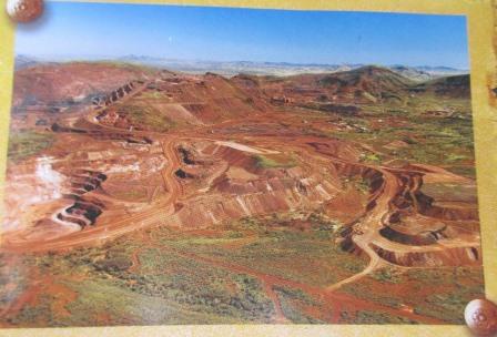
Looking
past the towers onto the Rio Tinto iron ore mine site and along the hill to
other excavation sites.


Zoomed
in on the loading area.


The
photo of the mine from the brochure. It is one of the biggest in the world.
The
track continued onto another ridge – looking back to the summit above the
towers.

This
view looks down over King Lake (the bright green triangle) and the van park
first. Then the speedway and water treatment pool below us. Over the township
of Tom Price and more hills.
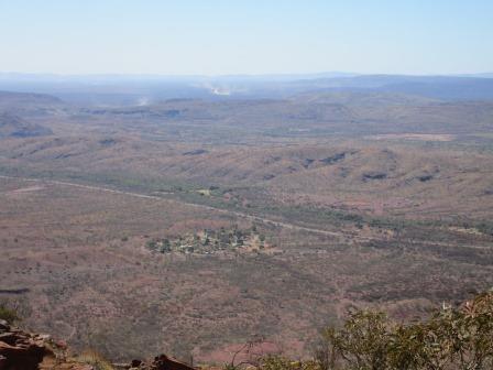


Our
van is parked on the clear area near the pool.


Further
along we found a directional marker.


Mt
Bruce and Mt Meharry are the 2nd and tallest mountains in WA. Out
there somewhere.


Another
view of the mine site and the accommodation village.


Zoomed
in on the ore pouring out of the conveyor belt.


Steve
spotted a ‘little truck’ running along the ridge – looked like a little Tonka
truck from here.


Headed
back down – looking across to an old area with loading area.


Drove
back into town for fuel and a gas bottle exchange – easier without the van on.
Picked up the van and drove around to Kings Lake which is man-made though no
swimming allowed. It looks lovely in the brochure.

The
grass area was nice but the lake was full of weeds so the photo was misleading.
This photo is the same angle as the brochure.


Looking
across the grass to Mt Nameless. Nice date palms and a big fig tree around the
toilets. Had a cuppa and checked the internet etc.


Headed
back under the ore train bridge with its ‘highest town’ sign.

Turned
right and headed towards Paraburdoo. Nice scenic drive.
We
planned to stop at the Half Way Bridge but there is now a No Camping sign – due
to flash flooding. Don’t think that will happen today but if it says no camping
we will obey. Another couple were there who had lived in the area for many
years. They said they had many fond memories of regattas held here after a good
wet season. Them said there was a truck stop with a quarry behind it and plenty
of area to park up about 2km down the road so we continued on. The rail line is
running parallel with the road but it is a bit further over at this point so
hopefully there won’t be too many trains go by in the night.
Not
the most picturesque camp site but it will do for a quick stop.

Had
our drinks while Steve read and I wrote up some of my blog.
After
dinner the phone rang – just have reception. Kerry and Brian are near Kunanura
heading home for their son’s wedding soon in Townsville. They had a good time
at Old Halls Creek. They stayed in the old van park there and were given access
to the guy’s three leases. They had fun in a gully and found a heap of little
species. Well done. We might have to go back!!
Only
one train rumbled by in the early evening.