7.30am
16 degrees, clear sky and the wind is still blowing.
Drove
into the Hamersley Gorge Road which was very corrugated. Stopped at the
Information Bay to read the notes. There is Wifi available here but you can’t
camp here.

The
road is now bitumen as it descends into the gorge – no signs about no caravans
so down we go. There is flat area with car parks though the caravan parking
spot is on the angle up the hill! We chose to back up onto the concrete island
therefore only taking up two parking bays in case others arrive. At the moment
we are the only ones here.
Lovely
colours in the rocks where they have excavated to put in the road.


Read
the walk sign and information about how the gorge was formed.


Walked
out onto the lookout platform to check out the view below.


Now
for the walk down the steps.

Fascinating
looking at the rocks and how they have been shoved and twisted.

Halfway
down we walked across to the edge to check out the water flowing from the top
pool to the bottom one. Everything is on different angles around here making me
feel very lopsided.

Time
for a selfie – haven’t taken one for ages.

Looking
up to the top pool.

More
photos of the twisted slabs.


Looking
over the bottom pool and further down the gorge.

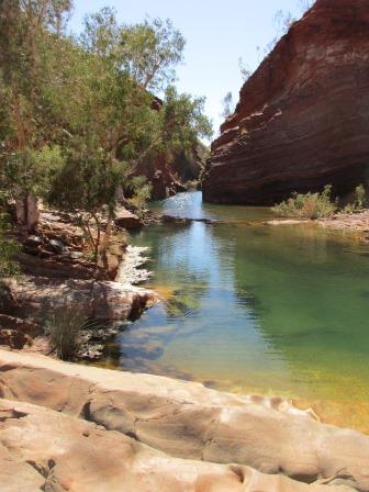
Walked
down to the bottom pool. The morning shadow is still on the wall but when I
zoom in the colours come out.


They
say it is a photographer’s delight – it will take me ages to sort through all
the photos I am taking.
I
checked out the temperature of the water – a bit chilly. I don’t think we will
be going in for a dip today. It is lovely and clear. Spotted a couple of small
fish.


More
shots down the gorge.


Steve
carried on over the big smooth rock around to the stairs to the top pool. They
could have put in a rail over the smooth rock for me! My knees got the wobbles
up on the smooth rock so I backed out and climbed back up to the first spot.


I
walked further along for another picture of the pool.

Steve
came back via another track that climbed up side of wall near the top pool. He
took me further up the hill for a better look down on the pool, the spa pool
and further on where the water flows out of the trees further up the gorge.
Looks very inviting but as I won’t be going for a swim I don’t think I will
bother going down there. Better view from up here.


Looking
back up the steps to the lookout platform.

Further
down the gorge.

Panned
around from bottom to top.


Walked
back up to the top then up the little track to the top of the hill. More people
have arrived.


Looking
over the surrounding hills then down over the carpark.


Steve
dressed for the occasion – he still has one set of his old work clothes. They
rest have slowly been burnt as they wear out.


Had
a cuppa and chatted with some of the people as they pass by.
Back
down to the bottom pool again. Getting our stair exercise again. I might have
to get knee injections too!! As the sun was overhead I took another set of
photos.


Steve
wandered across the smooth rock then I walked out too.


Looking
back up to the lookout platform – you can see why I feel lopsided.

Walked
back to the wall and checked out the rocks. Fascinating.


Climbed
back up to the top spot over the top pool – some have braved the cold water for
a swim.


Walked
a bit further up and zoomed in on where the water comes out of the trees.


Followed
a little track around the top past a big ant hill. That saved the walk up the
steps. The rocks have cracked making it look like someone has laid pavers – but
on a slope.


Made
some lunch and sat outside watching others go up and down the steps. The wind
has settled. I did a stocktake as we will shop in Tom Price as there is a Coles
there. Read for a bit then had a cuppa watching the mine workers enjoying their
swim. The shadow has gone from the wall.


We
headed off again – slow climb back out, glad there was bitumen. Back onto the
dirt road – everything has a red tinge.

We
turned onto the Mt Bruce Road and continued around the edge of the National
Park enjoying the view of the range. We passed a set of yards with hay then
noticed greenery and big travelling irrigators. Can’t quite see what they are
growing there but they have plenty of water as it is very green. (Found out that Rio Tinto is making extra money selling lucerne etc using the water they are pumping out of the mine below Mt Bruce. A lady said when she was at the top of Mt Bruce she looked down and could see all these bright green circles - because of the circular irrigation arms.)


Fire
has burnt the spinifex off this hill but not the next one.


Turned
onto the bitumen and headed right as left goes into Karijini National Park and
Mt Bruce. As we did that section three years ago and we aren’t too keen for the
10km hike up Mt Bruce, we continued on. Mt Bruce is 1235m – WA’s 2nd
highest peak. Mt Meharry at 1249m is the highest peak and can be accessed with
permission from the Juna Downs Station on the east side of the park so we will
skip that one too!
Across
the ore rail line that comes from Marrandoo Mine, which is beside Mt Bruce and
Karijini National Park. It goes to Dampier, meeting another line that comes up
from Paraburdoo and through Tom Price. They are all owned by Rio Tinto.

Pulled
off and up a track to the RIP Lookout. Named because people have left memorial
plaques of loved one who have passed away around here. More people have written
on rock slabs provided too. Very moving.


Nice
view too. Zoomed in down the valley.


We
decided it would be a good spot to stay for the night.


Had
a drink and read then cooked dinner. The wind picked up again. A couple pulled
in and set up their roof top tent – don’t think that will be fun to be in with
this wind.
As
we went to bed the wind was so strong it was shaking the van. Oh well at least
we aren’t in a tent!
No comments:
Post a Comment