Clear
sky again and light breeze. Headed into Albany to explore. Some clouds in the
east.
First
stop – Albany Museum and Brig ‘Amity’. We are early so wandered around checking
out the buildings and the ship. This lovely building is called the Residency,
built in 1856, as a store and depot for hiring convicts.


Walked
out onto the Welcome Jetty. Signs need to be redone. In 1826 the first European
settlers arrived in the Brig ‘Amity’ to establish a penal colony. The names of
the first settlers are on boards.


Princess
Royal Harbour then a little lake beside the Brig.


A
few heritage buildings have been moved here – Mt Barker Co-op Building and a
one teacher school.


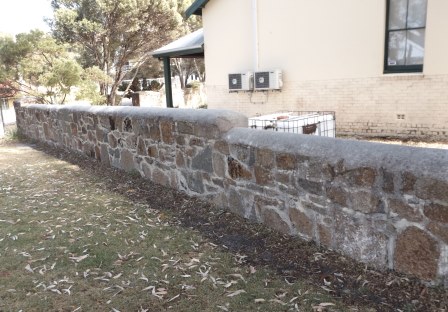
Beside
the building is the original sea wall beside the Police Cottages.

The
Brig ‘Amity’. The original was built in Saint John, New Brunswick, Canada in
1816 by Christopher Scott. This replica was built in Albany in 1975-76 by Stan
Austin. It is built to exact scale of original although no plans were found
when the project commenced. It was built using designs, techniques and
materials similar to those used in the early 1800s.


Mouchemore’s
Cottage is original.


The
Museum didn’t open till 10 so we kept going. Looking across to the grain silos.

Continued
down Princess Royal Drive past the silos then to the woodchip loading area.

Past
the Pilot Station at Semaphore Point – no entrance to that but I zoomed in on
Breaksea Island with its lighthouse.

End
of the road so turned around and stopped near the silos to get a photo of the
mural.

Looking
the other side to Mt Clarence and Mt Adelaide.


Headed
up the hill to Apex Drive with its avenue of memorial trees. Each tree has a
plaque.


Up
to the carpark at Mt Clarence. There are lots of walking trails all over the
two mountains. A bit of history.


The
Australian horses sent off to fight a war.


Now
the many steps up to the Desert Mounted Corps Memorial. A few information
boards along the way.


Desert Mounted Corps Memorial.


Gallipoli
Lone Pine.


About
Apex Drive.


Further
up to the summit and the Padre White Lookout. The Dawn Service was started by Padre White up here.


Fabulous
view.


Walked
further along the lookout platform – zoomed in on the wind farm then around
over Mount Melville.


The
summit.

The
Ataturk Entrance is only narrow – from King George Sound into Princess Royal
Harbour. In exchange for the Turkish Government’s agreement to name the beach
at Gallipoli where the Australian and New Zealand troops landed ‘Anzac Cove’,
the channel leading into Princess Royal Harbour was officially named ‘Ataturk
Channel’.

Back
down the access road to the carpark instead of the stairs!! Drove halfway back
to the Apex Lookout which looks over the east and Middleton Bay and Beach. Had
a cuppa enjoying the view and chatting with a couple. They have moved to Perth
from Brisbane but he was originally living in Cairns.


Back
down Apex Drive to Forts Road and into the Prince Royal Fortress area on Mt
Adelaide. The original parade ground is now the car park. Went into the
Garrison Barracks – part restored – the remainder not.


Inside
one room was a display of WW2 model planes etc. The rooms are all pine-lined.


Lots
of information to read.


The
kitchen area – very nice, had a pantry room next door.

In
another room was another display and on one wall all about the aboriginal
servicemen.


Next
was the Sentry Box next door to the Guard House.


Then
the Military Institute (now a gift shop).


Nearby
is a BBQ area which was the site of the kitchen during WW2.


Nearby
was the ablution block.

Further
down the hill was the Commanding Officers’ House – now a function centre.

Above
that (behind the Barracks) is the WW2 Quartermaster’s stores and billeting hut
sites and the big water tank.


The
curved building was the Nissen Hut (no info about that) and the Military
Heritage Centre but they were shut.

Around
the other side was the site of the horse and cart shed with a replica built on
it and the original manure pit – didn’t stink.


Across
the road was the Regimental Aid Post – there were a few stretchers etc inside.

At
the start of Convoy Walk was an artwork titled “Longing, Memory, Sight” by Arif
Satar and Audrey Fernandes-Satar. Inspired by a fragment of a letter a soldier
sent to his loved one, the sculpture contains inscribed text obtained from
original letters and postcards sent by Australian soldiers who departed in
1914.


The
Walk contains 21 markers containing information about the ships of the First
and Second Convoys, including the names and images of the troopships and
escorts, and where they embarked troops – as well has how many personnel and
horses were on board (too busy reading I didn’t take one with the horses listed
– there were so many).


Stopped
to reflect in the rose garden to remember the women in wartime.


It
is beside the Married Quarters.


Inside
this igloo building (very hot in there) was a display of the RAN & HMAS
Sydney.


Also
missiles, mines and submarines.


Next
to that was the site of the Warrant Officers quarters and Artillery Store.


Turned
off to check out the Coastal Defences area. Into the bunker.


A
tour group came in so we stopped and listened. The first duty of the day was to
go into the curved area around the ammo stores and place lanterns in these
cavities so the light could shine into the ammo store.
The ammo was brought up by horse and cart and then hand- passed into this area then lowered down one by one via these narrow rooms where there was a shaft at the other end.


As
the soldiers boots had nails in them and that could cause sparks on the
concrete this floor was laid with jarrah blocks.

Walked
through then up steps cut into the stone to the bunker for the Depression Range
Finder. Can’t see anything no as the trees have grown.


Around
to the first big gun aimed at Breaksea Island lighthouse!!


Steve
lent on the gun and it moved so he went to the controls and turned it to aim
for the ship!!


Back
up to the top of Convoy Walk to the Mt Adelaide summit.

Convoy
Lookout.


Looking
east over Middleton Beach and Bay.


To
protect the battery further in WW2 they built a nasty fence.


The
Naval Discovery Trail heads down the hill from this missile guidance thing.


Comes
out at a display of Naval guns, torpedoes and missiles. The blue one is the
Mark VIII Torpedo.


The
kids were having a ball winding the guns up and down and around.

On
the left is the SM-1 Surface-to-Air Missile and the Ikara Anti-Submarine Missile
on the right.


Down
the hill to the WW2 US ‘Still on Patrol’ Memorial.

Looking
back up at the National Anzac Centre. Lots of TV screens telling stories of the
conflicts our soldiers were in etc.

Info
about the signal station and US submarines.


Got
our lunch and sat in the park overlooking King George Sound. Very interesting
and thought provoking area. It is hard to imagine what those men endured as
well as all the loved ones they left at home.
Down the hill and around Marine Drive to Middleton Beach. A surf carnival was being held here in Ellen Cove so no parks here. Drove past the caravan park – one that is actually on the beach – and walked out onto the boardwalk to the beach.


A guy had a hydro-foil on the bottom of his surfboard while he was kite surfing.


Looking
east along towards Emu Beach.

Zoomed
in on the lighthouse on Breaksea Island – again – can see the house behind it
from here.


Mt
Adelaide and Mt Clarence.


Back
around Marine Drive on edge of Ataturk Channel. Stopped at a lookout – more
info.


We
could see the Plantagenet Battery and part of the man-proof fence.


Next
lookout was over the port area.


Back
into town on Stirling Terrace which sits high over the railway lines. Lots of
nice buildings here.


Big
clock tower on the Post Office building.


Outside
the Post Office is a telegraph pole that connected WA to the eastern states via
the Overland Telegraph.


Walked
back down the street and found a few more old buildings. Albany House was
designed by George Inskip and constructed about 1878 for the Union Bank.
Wrought iron verandahs were its main feature (which obviously have been
removed). Beside it was the London Hotel established in 1909.


Across
the road was a Rest Centre that was built in 1908 as a shelter for the drivers
of horse-drawn cabs. It remains a shelter for taxi drivers today and toilets
etc have been added for public use.


Further
along is the Old Convict Gaol Museum (1852) which is on the other side of the
railway line from the Albany Museum. We are museumed out so just took a photo
and watched a big train pass by.


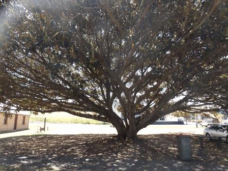
The
pioneers loved the Morton Bay Fig – they are everywhere.
Walked
around to the other side of the gaol – you wouldn’t want to try and escape over
the wall. The brochure says “ A complex of men’s cell blocks and some Warders’
quarters built in 1852 for Imperial Convicts shipped to WA as artisans and
skilled labourers. Women’s cells, the Great Hall and more Warders’ quarters
were constructed of brick 1872-1875. At this time the Complex was also used as
a Colonial Prison. It was last used as a Police Lock-up in the Great Depression
of the 1930s. Extensive restoration from 1989 to 1996 has returned the Gaol’s
condition to the original state. Cells, Warders’ Quarters and the Great Hall
contain appropriate displays.”


The
other major historical house is Patrick Taylor Cottage, built around 1832. This
unique eleven room wattle and daub home is the oldest surviving intact dwelling
in WA. It consists of an entry, box room, parlour, nursery, bedroom, dining
room, family room, sewing room, kitchen, laundry and side verandah and is
surrounded by a neat English country garden. Sounds just perfect.

Lots
of the houses around here are old and you can see where extensions have been
added to the original dwellings.

Across
the road is the Wesley Church built in 1863 and Methodist Manse built in 1903.
They were built using local granite with elaborate brick window surrounds and
are fine examples of late Victorian architecture.


Up
York Street (runs up the hillside) to the Town Hall.


Continued
along to find the Dog Rock – yes it does look like a Labrador.

Turned
around – trying to find the Coles Express servo. Found Coles and got a few
groceries then Coles Express but they were 141.9c/l for diesel where the other
servo we passed was only 129.9 – go figure. We filled up there instead.
Back
passed another church which is the first Anglican Church to be consecrated in
WA, built in 1848 – Saint John the Evangelist. It was Padre White’s home church
(the lookout on Mt Clarence is named after him). Popped my head inside – the
bell ropes on the wall.


There
was a glass door so I just peered in and zoomed in with the camera. Very
impressive.


Headed
back out of town and down onto Frenchman’s Peninsula again. Onto the west side
to check out the Wind Farm and Sand Patch Lookout. Now we know the name of the
little bird that was flittering around the Kangaroo Paw.

100
metre walk up the hill to the first lookout.


Another
100 metres up to the top of the hill to the second lookout. Great view back to
Albany. The silos make it easy to spot.


You
can still see exposed bits of the sandblow that gives this area its name.


Looking
across to the Stirling Ranges in the north.

Walked
back down then to the coastal lookout.


Headed
back to the main road. At the intersection we can see the big ship leaving
Princess Royal Harbour with the tug guiding it out the Ataturk Entrance into
King George Sound.

Into
Torndirrup National Park (another pay to visit one) and we turned to the west
side again to The Gap and Natural Bridge. This has all just been redone costing
a fortune. Near the carpark the ground shows the North Pole and how Australia
used to be millions of years ago.


The
aboriginal story of the Gap and creation of the shark and the stingray.


Dan
would be impressed with all the stainless steel – that would have been a good
job.


The
rescue of the tourist by the Cheynes II whale boat we heard about happened
here.


Lots
of people were on the Gap so we walked down to the Natural Bridge. Nice view
back up to Sharp Point and Green Islands.


Looks
like a fairly recent slip and maybe some more to happen.


How
the bridge was formed.

Looks
amazing. It is easy to see why people would want to go onto it and then when
the waves crashed under it you can see how easy it is to be washed out to sea.
Of course that doesn’t stop people as three louts were yahooing their way
across the bridge.


A
lighthouse on Eclipse Island.

Around
to the huge platform that will suspend us 25 metres over the ocean.


Straight
down. The water crashed its way into the narrow gap.


The
other side.

Put
the camera on continuous mode.


We were at the edge when more people arrived and next minute this lady cuddled up to
Steve – didn’t take her long to realised she grabbed the wrong bloke. We all
had a good laugh.

Looking
back to the carpark.

Looks
like they will all tip in.


With
the late sunsets we can cram a lot more sightseeing into our day. Just back a
bit we turned across Cave Point to Cable Beach. I walked down onto the rocks
for a view to the lighthouse.


Then
down to Cable Beach and along to Peak Head. The first point is where there are
some blowholes so we will head there next.


800m
walk with 78 steps to the Blowholes.
Hope they are blowing – it is windy but not too cold thank goodness as we
didn’t put our jumpers in.


Headed
down – looking across to Cave Point and its lighthouse.


The
blowhole is actually a long crack on the slope of this big rock.


A big wave sprayed up down below and there was a big roar from the blowhole but only the lightest spray came up.

Long
walk back up. Stopped half way for a view to Peak Head.

Back
to the track then around to Stony Hill. The hike to Peak Head takes 2 hours
return and is closed at the moment. We did the shorter walk around Stony Hill
where there was a Naval Observation Post and Signal Station.


Followed
the track through the bush and big rocks to a memorial plaque.


Climbed
up the big boulder past a concrete foundation of the signal station – windy but
not too cold.


Peak
Head is a lot further over.

The
sun is getting lower over the western side.

Looking
back to Albany.


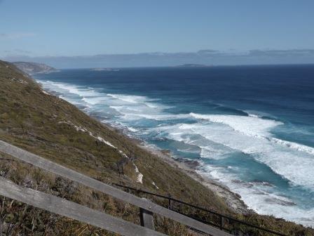
Along
way down to Flinders Peninsula – only hikers to that point, 16km return from
Whale World.


Some
‘bricks’ used to make a shelter.

Balancing
rock.


Continued
around the path onto a flat rock area with another fabulous view across
Princess Royal Harbour to the left with Vancouver Peninsula in the middle and
King George Sound on the right.


Back
to the truck then we headed back up Frenchman Bay Road till we turning right
into Quaranup Road. The sign said historic Quaranup Camp. When we got to the
end at Quarantine Hill there was a no entry sign into the camp which is for the
Dept of Recreation. I think there was a quarantine station here but no info
here.
Back along the track we turned off to a carpark for the Point Possession Historical Trail. 3 ½ hour return, classed difficult so we won’t be doing that one.


Looking
over Whaling Cove, the tombolo then Point Possession. On the other side of that
is Ataturk Entrance.


You
can see the National Anzac Centre on Mt Adelaide.


Back
down the road and Steve veered onto a dirt track to the beach. It was opposite
Mistaken Island. Looking back across to Whale World.


Last
look at Michaelmas and Breaksea Islands.

Headed
back home, late home, 7pm. We had bought little pizzas as they were quick to
heat up for dinner.