7am
21 degrees and sunny. Checked on the house insurance for Svendsen Street and it
has dropped $650 – that has to be a first. Apparently Comminsure has reassessed
its insurance guidelines and recalculated premiums according to the area rather
than the whole state. I am very happy about that.
Drove
back to Ludlow Tuart Forest to check on a free camp in a pine plantation. It
was in the Camps 8 but not on Wikicamps but there are a couple of vans and lots
of backpackers there so we might use that for a wash/blog catch-up day.
Just
up the road a bit we spotted a man on the phone beside his car with a smashed
bonnet then a dead big kangaroo by the roadside. Crossed the Abba River
following Tuart Drive (closer to the coast that the highway) – should have had
their CD on!! Back past Busselton on the main road (Caves Road) which is back
off the coast. All the church groups – there is a lot of them, have campgrounds
all along the coast with beach access.
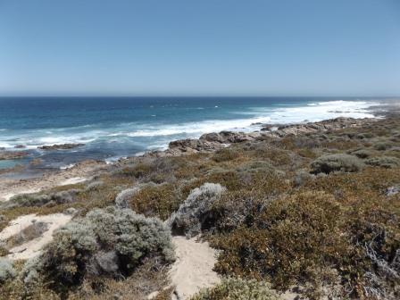
Onto
to Dunsborough – another nice beach area. It is also home to the largest
accessible dive wreck site in the Southern Hemisphere, the former HMAS Swan, a
120m decommissioned naval destroyer, scuttled in the bay off Meelup Beach. Drove
around and around to find a park near the Info Centre. Glad we didn’t have the
van on. Found out about the caves bookings and other brochures of the area.
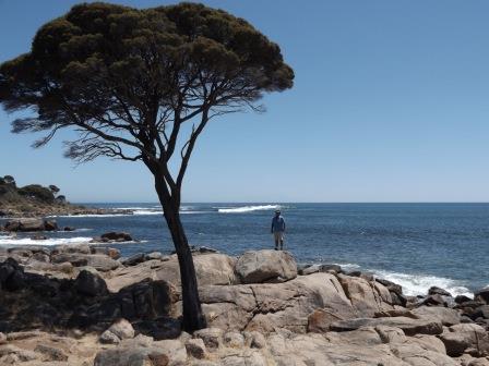
Continued on to Cape Naturaliste Lighthouse.

The
beginning of the Cape to Cape walk which hugs the west coast down to Cape
Leeuwin.

Forgot
to bring our fly nets – they are bad today!! Past the lighthouse keeper’s
cottage and other cottages under renovation and up to the lighthouse. Didn’t do
the tour so can’t get up the top – we could listen to the tour guide’s
commentary from below. Popular spot to look for Southern Right, Humpback and
Pygmy Blue whales during Sept and Nov.


Walking
back down the hill with a great view over Geographe Bay.

Drove
down a National Parks 4WD track to Windmills Lookout – no windmills though.
Should be as it is very windy here on the actual west coast.


Behind
us we could just spot the top of the lighthouse.


Back
to the Geographe Bay side to Point Marchant.


Walked
around to overlook Bunker Bay – popular swimming spot. Not hot enough for a
swim for us yet.


Crossed
over to the west coast again to Sugarloaf Rock Lookout and information about
the Red-tailed Tropic Bird.


Can
see more of the lighthouse from here.

Back
to the Geographe Bay again to Eagle Bay. Chatted with another Nissan Patrol (same as
ours – ex Telstra) owner. Young couple from Tas & SA touring WA for a year.
He has only had it a short time and it has a slight steering wobble.


Continued
along the beach road past lots of lovely beach areas like this one.


Stopped
at Gannet Rock for lunch under a big shady tree. Getting hot in the sun but in
the shade it is lovely and cool. Looking at Point Piquet first then the little
bay and all the rocks.


Down
the hill to Meelup Beach – very popular spot.


Not
sure what the white is on the rocks.

Up
the hill to the lookout over Castle Rock Bay (below where the boat is) and
Geographe Bay.


They
don’t have enough parking for all these beaches when it is holiday season. We
found one though and wandered down to the beach at Castle Rock Bay.


Need
to be out to sea to see the ‘castle’.


Across
to the west coast again to Ngilgi Cave (used to be Yallingup Cave till 2000).
Dad had given me info on this one so we joined a tour. Looks interesting.


An
echidna and spider carved out of a log.

National
Parks map.

Lots
of information inside the office. In 1900 a Caves Board was established in
order to properly manage public access to the show caves. Between 1901 and 1914
more than 14 caves in the region were developed for tourism and recreation. The
first cave in the south-west to be developed with electric lighting was Ngilgi
Cave in 1903 while the caves in the Margaret River area are still being lit
with magnesium lamps.


Met
our guide at the hut where there is the story of Ngilgi the good spirit and how
the cave was formed. The tour is self-guided – the guide gives you the basic
information, takes us down the stairs and then we can wander around exploring
at our leisure for as long as we like.

A
plaque near the entrance of the cave.

Still
the same entrance they used many years ago though now there is a lovely jarrah
staircase rather than a rope ladder.

Down
we go and looking back up at the staircase.


The
kids darted straight off to go down the tunnel – a slide through the rocks.

Stalactites
hanging down into the Amphitheatre.


Info
boards are illuminated. Found the signatures on the wall. Very interesting that
they found Tassie Devil bones in here.


Took
photos of the illuminated formations as I can’t get the flash to work!!


Up
the stairs and into the main chamber which is a large area we just meander
through and around till we come back to the main entrance again.


Down
some steep steps carved out of the rocks.


Nice
formations.


Into
Cupid’s Corner. We are now 37 metres below the surface.


Critter
info.

Zoomed
in on the bottom that might have been a creek area.


Well
lit ones. A lady was here to show us the crystals. We used her light to try and
fix the flash but no luck.


The
flat wavy ones are interesting.


Looks
great with the different colours.


This
one was clear. Zoomed in on the surface.
Creek
bed area with lots of thin ones.


Continued
along the boardwalk.

A
little cave which has dog-tooth crystals hanging inside. It’s called the Jewell
Casket.


Two
tonne stalactite.


Last
two before we got back to the entrance. It was lovely and peaceful walking
around and it actually got quite warm in the middle where the lady was with the
crystals. They say 90 percent humidity and of course less oxygen but we didn’t
feel faint and I didn’t think it was as humid as home!!


Looking
up to the opening and the lovely staircase.


Under
this sign 37 metres below is Cupid’s Cave we were just in. We spent 1 and ¼
down there. I like this type of viewing – much nicer than trudging along with
other people.

Down
the road to a look out over Torpedo Rocks. Looking across to Smith’s Beach
where there is a resort nestled into the trees on the left.


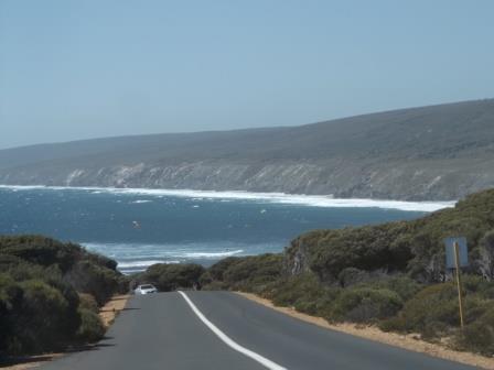
Then
down the hill overlooking kite surfers catching the big swells rolling onto
Yallingup Beach. They have a big surfing classic here in December. The
coastline on the other side is in the Leeuwin-Naturaliste National Park and
goes down the coast.
Stopped
at Slippery Rocks Lookout to watch the kite surfers and a couple of
windsurfers.


They
were great to watch – this guy was doing well then he flipped and it took a
while till he got back to the flat platform rocks to get back to shore again.

Drove
through the main car park area with lots of big homes going up the hillside of
Yallinup. Into the National Park to a lookout there. Looking back over the
beach to Slippery Rocks then along the beach and up to the north.


Back
up to Caves Road then turned off to Smith’s Beach. While Steve was making a
cuppa I reread my camera booklet and discovered I had to unlock the flash on
top of the camera so it could pop up!! Another mystery solved.


Back
up to Caves Road again, past a lavender farm and lots of wineries, then down
another road to Canal Rocks. I had a note there were rock formations to check
out. Info was about the rocks and the nice view over the bay back and across to
the National Park area north of Yallingup (the white bits are all the houses on
the hillside at Yallingup).


More
info about what’s beneath the waves.


Walked
around the corner to a wooden boardwalk and bridge over a canal. The
huge swell rolls in a one end crashing through the opening and down the canal
into the bay. Some people had been swimming in it – luckily no one got hurt as
it certainly hurtles the water through.


Walked
across the bridge for a better view.


Behind
us was another smaller canal.


The
waves crash over the rocks making waterfalls too.


Put
the camera on continuous shot for these photos.


One
huge wave came through making the canal roar. Got a video too.

Walked
back around to the carpark then through the rocks for another view.


Drove
up the hillside to the lookout. Would be a top spot for a sunset photo or even
down on the bridge as the sun would set in line with the canal.


Back
up to Caves Road again and then down another road to the coast and around to Wyadup
Bay – looking back on Canal Rocks. Along way round for not far on the coast as
we had to go around a big grazing property – he has a top spot here.


Very
rocky here then back to sand as the coast head south to Injidup Point on Cape
Clairault with a big sand dune area that would be great for sliding down.


Great
rock formations here.


Below
was another canal though it was sidewards. The water hurtled through one canal,
hit the rock wall and sprayed over the edge making a great spa in the canal
below. A few people were down there enjoying the bubbles. Got a video of this
one too.


Back
up to the main road and further down to Moses Rocks Road. Turned left and went
along the dirt, very corrugated road (National Parks section) which is also
part of the Cape to Cape Walk. Big sand dune on one side and another on the
other.


Great
view from the top.


Zoomed
in on a big rock which I gather is Moses Rock as it looks a bit like the rock
Moses stood on to part the sea. I like this continuous shot mode!!


Nice
big limestone cave up on the hillside.


Went
further north along the dirt road to a lookout and a lot of stairs down to the
beach. Obviously a favourite surf spot.


Windswept
sand over the sharp rocks.

Walked
half way down.


Getting
late so we headed back to Caves Road then turned east towards Bussell Highway.
Past lots of wineries, one sign caught my eye - Sandalford Wines was
established in 1840. Lots of other ones with weird names – House of Card,
Swings & Roundabout, Knee Deep Wines.

The
maps are great.

Up
the highway to Vasse township and bypassing Busselton back to the van. It is
fun listening to Steve argue with ‘girlie’ about the speed limits – I should
tape him one day!!
Had
to cook tea tonight – ran out of leftovers!! Warmer evening. Put the togs away
as we didn’t get time for a swim – maybe tomorrow.
No comments:
Post a Comment