Light
shower of rain early this morning – cloudy now. Jess’ birthday today – sent her
a text when I got reception up the hill.
Headed
south west down a dirt forestry road to the Vasse Highway, across the Donnelly
River then the D’Entrecasteaux National Park. Headed towards to coast to the
boat ramp into the Donnelly River. From here it is 11km to the Southern Ocean.


Good
fishing for marron here – look there is one waiting to be taken home, shame he
is too small. Have to have a licence to fish in freshwater and another one to
fish for marron – licences everywhere over here.


Back
up to the main road then we turned off to Beedelup Falls in the Greater
Beedelup National Park – we have our parks pass so don’t have to pay the fee to
walk down to the falls.
The
Karri Forest Explorer is a drive around the area with ‘ranger’ notes along the
way.


Only
a small view from the lookout over the lake and the resort. Originally the land
was bought to grow hops which was used by the Swan Brewery and in 1960s the dam
was built to increase irrigation supply. By 1978 hops were no longer a viable
crop and the land was sold off as an estate. One parcel was bought and used as
a trout retreat in 1985 then the Orange People took over and started a school
and retreat but they eventually sold out. Then the Karri Valley Resort started.
Looks a nice spot.


Down
the path to the falls – it is best after winter rain of course but too cold for
us to be here then!! It is a 106m fall.

Downstream
is a suspension bridge.

We
crossed the little bridge at the top of the falls – looking upstream.

The
other side looking over the falls and the lookout platform.

Onto
the suspension bridge which was very wobbly but Steve made it across ok (he doesn't like these bridges).

Better view of the falls.


Downstream.

Up
a hundred (or so it seemed) steps and back to the truck for a cuppa in the sun.
Should have worn my jumper as it was quite cool down there. Followed another
track to the ‘Walk Through Tree’, about 1.2km away. Bit of a rough track up
hill then down and then up again. Lots of big trees along the way with new
little ones growing up beside them.


A
lot fall down too. I hope this isn’t what they mean by the ‘Walk through
tree’!!


Up
and down a bit more till we found the ‘Walk Through Karri Tree’ and it really
was. It is 75m high and 2.4m in diameter and still growing.


The
outside bark is slowing growing around and inside the hole as the date 198? is
missing the last number now.

Out
the other side. My turn for a photo – otherwise my boys won’t think I was here
at all!!


Continued
along the path till we got back to the creek then around the lake.


Back
to the highway and then down a road through the Warren National Park towards to
the ocean again till we found Yeagarup Lake – still 10km from the ocean. Very
dark with tannin so looks black and gloomy. Across the lake we can make out the
tops of Yeagarup Dunes.


Continued
along the track – signs advising to drop tyre pressure to 10psi to continue but
Steve drove on with 40 in the front and 60 in the back tyres but in high 4WD.
The road surface was good and it was damp from the rain so all good.

Got
to the beginning of the dunes and parked up – won’t be going any further
without dropping the tyre pressure. Walked up the dune. They are steadily
moving inland swallowing up the forest lakes and woodlands as they go.


Up
to the top of the first one, looking back over the track and towards the lake.


Panned
around – lots of sand and the wind was whipping it up.


Two
Dutch chaps arrived – they are impressed.


They
had let down their tyres and were heading to the beach about 8.5km away. They
had to stay between the white road markers for the safest way across the dunes.


Back
out to the Old Vasse Road where we got some phone reception. Rang Mum to see
how she went with the specialist – doing well so all good. I said we are going
to the see the tree and climb it. They had visited here on their trip over here
and she reckons I will change my mind about climbing it when I see what I have
to climb up on. Stopped to check out the Info Hut for this section of the Karri
Forest Explorer.


Down
the road we found the Marianne North Tree which she painted here in 1880.
Hasn’t changed much.


Around
to the Dave Evans Bicentennial Tree for lunch.


Watched
a few people go up and down the tree and thought I would give it a go. Steve
said ‘no way’ – he hates heights and his glasses don’t make it easy either.
This is the highest of the tree ‘fire tower’ trees that are open to the public
to climb. A family were having a go and the kids went up a little then came back
down so I said I would do the same. I got my smart phone to take photos as I
could put inside my shirt and Steve had the other camera to take photos of me
going up.


Up
I go.


Made
it to the 25 metre platform and felt great.


My
photos from the platform.


Continued
up to the next platform high up in the branches.


Steve
is getting a lot smaller.


In the branches now.


Looking down the spike spiral staircase.

Now
up the metal ladder within the platforms.

Then
the next one – that was the scary bit as it wobbled a lot.


Another
long ladder that wobbled a lot too.


Steve
can just see me going up to the fourth platform. He had to walk all the way
back around the shelter shed to be able to see me on the high platforms.


Someone
lost their shoes.

Last
ladder to the top.


Can
just see Steve.

There
are love locks up here too. I wonder if the bonking man from the ‘walk through
tree’ has been up here with his wife!! Fabulous view, well of tree tops, though
I could make out the sand dunes. Walked around the tower taking photos then did
a video.


The
wind blew hard just I started back down the first ladder and boy did it wobble
up here. Stopped for a photo as I reached the last of the top 5 platforms.


Now
for the hairy bit – going back down the spikes, backwards. Slowly, slowly is
the key.


Down
to the 25m platform. Feeling fine though my feet arches are feeling the spikes
a lot.


Back
on the ground and yes my legs are a bit wobbly. Sat down under the tree for a
bit to eat my apricots. Steve was impressed that I made it the whole way up. I
was very pleased with myself too and it was free!!
Another
couple arrived and we chatted about climbing up. He laughed as he said he was
an arborist in his younger life – now life had caught him up and he wasn’t so
keen to climb a tree again. He decided to go up a little way just for a photo.
I took a few more photos – of course!! It was an amazing experience.


Now
I read the safety sign – 65 metres to the top platform!! Wow.

Once
my legs had recovered we read all the information boards. A bit of reflection
on the boards. The Warren National Park was originally gazetted Crown Reserve
for the purpose of State Forest in 1901. In 1910 the gazettal was changed to
timber for government purposes. It was changed again in 1915, this time to ‘A
Class’ reserve for National Park. The park now covers just under 3200 hectares.
Well fancy that it wasn’t used as a fire-spotting tree originally. Glad I
hadn’t read this first – especially about the swaying bit.


The
original way of climbing a tree to see if it was suitable for a fire tower.
Great shot of a tower above the tree line.


Still
can’t believe I made it all the way up there.


Back
in the truck I rang Mum to skite that I made it up the tree. Had to turn back
to continue around the Explorer Trail as the next section is one way. Stopped
at Maiden Bush picnic area where a chap had his pots in and had caught a few
marron in the Warren River.


Further
along was Heartbreak Crossing – not info why it is called heartbreak.


Upstream
then downstream of the Warren River.


Continued
along the dirt road past Drafty’s then Warren Campsites then climbed up to
Warren Lookout. Only a small view though of the river.


Interesting
fact about the salt content. Should have tasted it when we were at the
crossing.


Left
that trail then headed towards Pemberton. Turned off to check out The Cascades
on the Lefroy Brook.

Some
interesting information about the Lampreys. They were in the Margaret River too
– creepy looking things.


View
from the platform – certainly all these creeks and falls would look better in
winter after the rain.


Walked
across the bridge – Steve spotted a small marron.

Heard
a motorbike zoom by across the creek then a loud blast. First we thought it was
a truck having problems with the motorbike but then it tooted again and we
realised it was a train. There is a tourist train that runs out here along the
edge of the brook from Pemberton. Walked up to the cascades section.


Walked
into the middle for a shot upstream.

Back
across the brook then we followed it down another track to another bridge over
the brook (upstream).


Lovely
flower – like a ground orchid.


The
old foot bridge – looks like it was a one-tree bridge too.


Walked
down along the brook to the road bridge – lots of trees used to make this one.

The rail bridge.

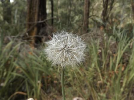
A
puff flower – can’t remember what we call them.
Back
up the main road through Pemberton – nice little town, lots of timber history
here. Turned onto a dirt road again to find Big Brook Dam - Pemberton’s water
supply. There are lots of small dams everywhere used for irrigation.

More
of the Karri Explorer boards – these ones are letters home showing what life
was like in the early days.


Big
Brook Dam was built in 1986. There are picnic areas amongst the karri trees and
a walk around the dam, half is on the Bib Track. The water is clear – no
tannin.


Walked
to the middle of the dam wall. Two kookaburras were chatting to each other –
one on either side of the spillway area.


Looking
across the dam and back over the wall’s walkway.


This
duck was having a great bath. Just a few pesky lice to evict.


As
we started driving off Steve spotted this silhouette in the bush. It was in the
shadow so had to zoom in.


Continued
along the forestry road – stopped to check out another Big Karri surrounded by
hundreds more. There was no info on this one.


Heading
up towards Manjimup I said to Steve we will turn right to the Diamond Tree. He
saw a blue sign and turned but it was to the 100 Year Forest. Meandered along
for a while past smouldering trees and eventually came to another sign for the
forest – it is the one smouldering. Info I have on it says it was once cleared
to grow wheat and now it is a thriving karri forest and is a popular tourist
destination. Obviously it will be closed for a long while now till it recovers.
Can’t have been a burn-off this time of the year. You would have thought they
would have put a sign where we turned off saying that it was closed due to
fire.


Back
to the Vasse Highway and the Diamond Tree. Another fire lookout tower built in
late 1930s – used 1941-47 and occasionally since then. The lookout cabin floor is
51 metres up. This must be the one in the photo back at the Bicentennial Tree
showing a cabin peeking out of the forest.


Steve
had a go at climbing it – these pegs are more ladder-like than the other one
which spiralled around the tree more like a staircase. That’s enough for him.


Looking
straight up – this one has a lot more limbs.


Too
much reflection on the info boards. The Diamond Tree cabin was built on a 6
metre tower above the main tree fork, originally giving a total height of 54.5
metres. Amazing feat. First they had to climb trees to choose one suitable then
cut off the lower limbs. Drill holes in for the pegs to make the ladder-way.
Timber for the cabin was cut on the ground then winched up to the top and the
cabin built there. In March 1947 the local newspaper reported that a falling
branch had wiped out 9 metres of pegs with the tree lopper (Dick Sproge) 38
metres up the tree. He wasn’t worried – just lowered himself down using a thin
rope.


The
first person to sit up the tree watching for signs of fire was Mabel Saw, a typist
at the Forestry Dept in Manjimup. In 1974, fire surveillance from Diamond Tree
ceased and spotter planes were used instead. The tree lookout was re-furbished
in 1991. Three metres was cut from the upper branches due to fungal rot. The
cabin was lowered to the ground with a crane, where it was repaired before
being hoisted back up again. The cabin floor is now at 51 metres and a viewing
platform at 46 metres.


While
we were reading a young Asian lady started up the tree.

Nearly
at Manjimup we took a road west to find Fonty’s Pool. Archimede Fontanini
originally dammed the stream with a log and earth. Locals convinced him to
cement the dam and develop the garden and charge an entry fee to cover
maintenance costs. In 1925 Fonty’s Pool was officially opened and became a
well-known spot in the South West. Archie maintained the pool and gardens until
1973 when at the age of 93 it became too much for him and the pool was closed.
In 1979 the pool was reopened with a “Back to Fonty’s Pool” log chop and
swimming carnival. 12,000 people attended. In 2005 the public liability
insurance policy was finally revoked and the pool closed again. It was sold to
Jeremy and Kelly Beissel who have reopened the property and the pool as a
caravan park with public access (by admission fee) to the pool and garden. We
drove in for a quick look. Found the log chop arena. There were some old
buildings on the other side.


Fuzzy
shot of the dam wall and pool.

Nice
house on the other side too.


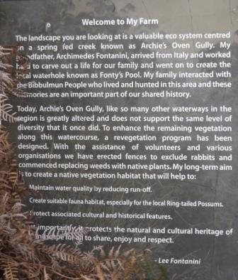
In
the bushes as we headed out I found a sign by Archie’s grandchild, Lee.
Back
up the dirt road to Graphite Road and then west to our camp. Big day out,
luckily I had made tea in the Ecopot this morning so it was all ready.
No comments:
Post a Comment