7am
21 degrees. Uploaded the last of my blog – I am now up-to-date at last. Sad
news from Sandy that about a couple we spent time with, Bruce and Julie. Julie
had passed away and they had only been with Tom and Sandy four weeks ago.
Put
the sheets in the wash then finished packing up after breakfast. Kaylene texted
to see if we left and to see how Mum and I were. I texted ok at the moment but
it wasn’t long before we were in tears!! So hard to leave after spending
quality time with them and knowing I will be so far away and no help to them
but she can get me on the phone (well sometimes) so will keep in touch. Hung
out the washing then did her sheets and made the bed. Had a cuppa with them
while we waited to hang out the sheets then washed their car. I have been so
glad to be able to give them a helping hand.
Time
for farewell and lots of hugs, kisses and tears. Well lots of tears for Mum and
I, Dad was just hugs and kisses of course, no tears there. I love them both so much.


The
sun is out but there are still a few clouds hanging around the mountains as we
head south. Still very windy. Texted Dan, Fran, Jon and Jess to say farewell
again. I love them all so much. Texted Erica to say we had left and hoped they
had a good trip so far to Cardwell. She replied they were good and were in
Ingham.
At
Gordonvale turned to head up the Gillies Range. Half way up we found out what happens
when a truck and trailer meet a low loader on a corner. Very slow movements but
they managed to pass each other with only a couple of guide posts biting the
dust.


Our
new music box is working well. Our CD player had died so I got a speaker box
from Kmart and put the songs on a micro usb and we have tunes as we drive
along.
Up
to the Tablelands and the grass is looking a bit greener after the recent rain
since we were up here with Bob and Margaret. They are home in Dawesville, WA
again. The Jacaranda trees are starting to bloom.


Through
Atherton then headed to Ravenshoe. We have crossed the Barron River three times
before we turned into Mt Hypipamee National Park or as we call it ‘The Crater’.
Went to the toilet and a brush turkey had been very busy clearing all the
leaves away.
He
decided he wanted to be our friend and started to follow us back to the truck.

We
followed the track.


Took
the right fork which took us beside the Barron River. Great information board.
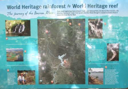


It
flows through the narrow rocks, over falls and then over Dinner Falls. First
section.


Below
that section looking up at the falls then as it continues down.


The
next falls.

Then
down to a lovely falls which had a concrete weir across it with a gap in the middle
for the water to flow through and continue down over Dinner Falls. Checked the
water temperature – very cool.


Time
for a selfie to celebrate being back on the road again.

Unfortunately
they prefer you not to go below Dinner Falls and the barrier didn’t provide a
good vantage point for a photo.


We
had walked down to the falls, now the walk up to check out the Crater.

Boardwalk
and viewing platform now – well we haven’t been here for many years!!

Still
green and murky. A chap had just dropped his phone over the side and we heard
the other couple saying he got a bit of wire to retrieve it – lucky. That is
why I like my little camera with its wrist strap. Once a dog fell into it
before these barriers of course. Can’t remember what happened to the dog.


Good
information board.


Amazing
how trees grow anywhere in the bush but you can’t get them to grow at home!!

Walked
back up the other track. This poor tree has been invaded by something causing
lots of lumps.


A
beautiful straight tree with huge staghorns near the top.


Nature’s
art.


Back
to the truck for lunch then onto the highest road in Queensland, 1162m.


Lovely
views.


Through
Tumoulin where the historic steam train runs from here to Ravenshoe. We did it
many years ago with the Milhinch’s when we were camped at Ravenshoe one
September school holidays. Drier countryside compared to the dairy part of the
Tablelands.
Into
Ravenshoe, Queensland’s highest town (pronounced Ravens-hoe) at 920 metres
above sea level. Population of about 1000. It is situated on top of the Great
Dividing Range. Pretty little place.

Past
the highest pub (1927). Everything is ‘highest’ around here.

The
Club Hotel was built earlier though, 1911.

Great
photo on top of the real estate. The timber industry was very big here. Val
came here with her parents and siblings many years ago. I have a copy of a
letter written by her mother describing their journey to get here – quite
amazing.

I
realised I hadn’t downloaded the Offline maps for my new tablet so we pulled
into the Information Centre where they had free Wifi. ‘Crow flies’ distance
indicators and the rainfall indicator.


Big
Cadagi tree in the courtyard.


Had
a lovely time chatting with the chap and wandering around looking at the
displays while the files uploaded. This is a display of nocturnal animals. You
use a torch to peer in and see the stuffed animals.

Info
about our ‘lovely’ cane toad and some specimens.


Beautiful
butterflies and bugs which I don't like. Hercules Moth, Birdwing and the Blue
Mountain (Ulysses) butterflies.


Some
old items on display and some information. The photo above the real estate was
Gordon and Prior with the first traction engine hauling to Ravenshoe in 1916.


Lovely
old toys from early 1900s.

Timber
industry was big here.


During
World War 2 there were many soldiers training up here.


Big
chilly up here too. When we were here once in September it was 9 degrees
overnight and we were camping.

A
new Aboriginal display is open.


A
new historical display with a collection of photos the locals have assembled.


Continued
on, over Millstream River – not stopping this time to look at the falls. Lots
of WW2 old camps along here. Signs saying which division etc and some old
chimneys from the camps.
Over
Archer Creek – a few people using the free camp here.
Through
Innot Hot Springs – Dan and Fran are coming up here soon to enjoy the thermal
baths in the van park. Nettle Creek looks a bit dry at present but there is
some water there.

Mt
Garnet next. Shame the mural is being covered by the plants. Lovely big hotel.
We came out here when we were kids with Mum and Dad for the Mt Garnet races. I
remember a chap playing his bagpipes at all hours of the night.


Passed
the road train stop where they drop their third trailer. Dry scrubby country
with lots of ant hills. Stopped for a cuppa at 40 Mile Scrub picnic area. Using
our new butane stoves as the last one was playing up after 4 years of making
coffees. Lots of caravans and road trains whizzing by.


Plenty
to read here.


There
is a walk through the rainforest but I gave that a miss.


Dropping
down off the plateau on top of the Great Dividing Range 800m to 700m.

Continued
to slowly descend to 600m to Lynd Junction. No fuel for the next 257 km till
Hughenden but we are all good with our long range tank. Past the turn off to
Copperfield and Cobbald Gorges – will have to do them one day but you have to
pay someone to take you through in a little boat. End of the bitumen for a
while.

Alternated
between dirt and bitumen. Across Bundock Creek causeway which has a lagoon one
side and is dry the other.

Road
works – onto detour track which they have just watered. Steve not happy as his
lovely clean and polished truck is getting dirty!!
Back
onto the dry dirt then another very long stretch of road works with a detour track.
Huge camp for the road workers.
Onto
the bitumen for a bit the back onto the dirt again. Spotted an echidna
wandering across the road. We are still 100km away from Porcupine Gorge!! He
was good enough to pose for a few photos then wandered off into the bush.


Entered
Blackbraes National Park, named after the station that was here. We turned off
into Moonstone Hill camp area. Erica and Terry had found some moonstone and she
had put some in Steve’s box so he knows what it looks like – clear quartz rocks.
We drove around to the back of the hill and found a spot to camp.


We
could see where others had been digging on the side of the hill and wandered up
for a look. Looks like they have been using sieves as there are different rock
sized piles.


Found
some little bits which are good enough for us. Need a wash but it is getting
late so will photograph them tomorrow.

Back
to camp for a drink to celebrate being back on the road again. I started
writing my blog – don’t want to get too far behind again.
Map
of today’s journey. The highlighted numbers are where we camp each night and
the code for the Camps Australia book.

No
fires allowed here and with all the grass about I can see why. We will have a
bird bath tonight. Few mozzies about as the sun disappears.
7pm
22 degrees. No phone reception here. Cooked dinner then played Skipbo.
I
think it must be full moon tonight or there abouts. Caught it just as it disappeared into a
cloud.

The
wind picked up by coffee time so we had to give up on the cards. An owl swooped
down beside us after a moth – gave me a fright.