Overcast
morning. The washing I had hung out yesterday is still damp.
Packed
up. Said good luck to our cyclist friend. He still has a lot of pedalling to do
yet.

Headed
back up the telegraph track. Stopped to check out a grave I saw yesterday.
William Brown was a linesman for the OTL and used a brush hook to clear the
scrub. He died here from a heart attack in 1945.


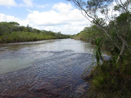
Back
through the Heathlands Reserve to the Bypass Road again. Stopped for a cuppa at
the intersection. The Bypass Road is now narrower with more tree vegetation.

Through
a section of rainforest as we passed the turn off to Captain Billy’s Landing on
the east coast.

Still
up on a ridge/plateau of 155m elevation. Glimpses through the trees of endless
tree tops to the west.
Wider
sandier section – still corrugated but now as bad as when we did it previously.

Certainly
better driving in the table drain.

New
stretch of bitumen.

Arrived
at the intersection of the top of the southern section of the Old Telegraph
Track.

We
continue on the telegraph but of course it has been widened as it is part of
the Bypass Road.
More
dirt which is quite corrugated so we spent most of the time in the table drain.
Lots of vehicles still heading south. A few towing vans too.


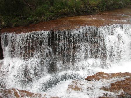
Turned
off the Bypass and went down a narrow track to Fruit Bat Falls. There parking
areas but not enough as it was full. We found a spot in front of an access gate
and parked up. Unfortunately they don’t provide any seating near the car park
for picnics. You have to carry everything down the track to the picnic area
which is nowhere near the water either or the toilets!! Really smart. Changed
into our togs then read the info before heading down to the falls.


Down
the track where there is evidence of pigs digging up the ground.


Onto
the boardwalk – lovely view of falls. Even though it is cloudy I am looking
forward to a swim.


Turned
left and down to the rocky area to go in for a swim. Bit cool but I had
expected it to be colder. Probably because the water flows over the shallow
rocky section upstream so it gets warmer. Steve took a video.


The spa from the water coming over the falls was wonderful.


Steve
got in so I took a few photos and a video. The others got in and enjoyed a
lovely swim and spa. Other people were using a hole in the rock above the
falls.


A
few little fish swimming around us.

Everyone
cool and fresh. As we headed back up Steve pointed out the Pitcher Plants
growing well where water was seeping out of the rocks.


Up
the boardwalk – we walked to the other end where the other people had been in
the hole in the rock.

Zoomed
in upstream.

As
we headed back up we saw our cyclist friend. He had come off over some rocks
but luckily some other nice travellers helped him out.

Back
to our vehicles and back out to the telegraph track and we turned north to
check out Eliot and Twin Falls. Track eroded on the sides.

Arrived
at Scrubby Creek which is quite a long water crossing but they have put in a
bypass which we checked out.


A
chap towing a van was checking it out so Kerry & I walked down to video him.


The
guys then came down and up the other side. Bob didn’t give it enough gas and
had to have a second go to get up – still having that flat spot issue. After
they went through another 4WD came through the longer deeper section – no
worries.
Looking
upstream where the longer run is from where we crossed. Then a shot of the
longer section approach and exit.


Continued
along the old Telegraph Track – lots of old bent telegraph poles. Very
corrugated in parts and nowhere to get away from them.


Past
the turn off into the camping area – a long way from the falls. Parked in the
Day Use area and had our lunch by the vehicles as again the picnic area is
nowhere near the car park.
Headed
down to the falls. Stopped to read the info. Our mate isn’t the first one to
cycle up the Cape.


Followed
the boardwalk to an intersection – no signs so we headed left first. A pool in
Canal Creek above Twin Falls.


As
we went down the stairs Twin Falls a shower of rain came down.

Will
do the rest of the walk and see if we want a swim after that.


The water then flows into Eliot Creek. Took a video of the view.

Continued around the dirt track following Canal Creek downstream through the rocks to Eliot Creek.


The
others were further along heading to Eliot Falls.


Zoomed
in on the falls.

Further
along – view down and upstream.


Steve
and Mal were checking out the falls.


I
walked up to them over the flat rocks. Not slippery but you still had to walk
carefully.


Mal
thought he saw gold so Steve dug out some dirt – no gold.


Eliot
Falls.

Walked
around to the other side with Steve to hang on to while I took photos and a
video.


Walked
back up the boardwalk. Found some more info.

We
walked back to Twin Falls and had a dip. Others were enjoying sitting in a pool
above the falls.


The
picnic area!!

Back
to Scrubby Creek – took photos of Bob doing the crossing.


Back
out to the Bypass Road and headed up the west side of the Old Telegraph Track.
Corrugated for a bit then onto a nice smooth road then onto bitumen.

Road
to Vrilya Point is fenced off so we won’t be going in there. Wikicamps says it
has been closed by the Community. I won’t miss the old log crossing, I must
admit.
Back
onto the dirt which is still smooth (160m elevation) then we turned onto a
track to head back east to the Old Telegraph Track again. Nice and green along
this track with bright red ant hills.


Turned
onto the Telegraph Track and headed 1.6km south to Bridge Creek and camp spot
called Nolans Brook Crossing. The track was eroded but there was a bypass track
around the rough bit. The track was all downhill as we got to Nolans Brook the
elevation was down to 58 metres.


The
sky is clearing.

A
few people were in the best camp spot – right above the creek so we parked on
the other side downstream of the crossing.


Walked
down the track to the crossing. Water flowing out of the ground.


The
boys walked around the other side (over a log bridge!) Another one with lots of
choices for the 4WD enthusiasts. We did this one too back in our younger days
and Steve said we did the 2nd one from the left in just our vehicles
with Steve and Suzanne and the kids.


Don’t
jump up and down as there is nothing underneath you Steve.

I
walked around to check out the log bridge – I’m not going to walk over that.

View
to left and right of it. This was another crossing point at one stage.


Two
vehicles arrived on the other side so we watched them cross. I videoed the
first one then took photos of the next one. They made it look easy.


Steve
and Mal got in our ‘pool’ for a dip. It is a bit hard to get in and out so
Steve put in a rope. The current is quite strong too as the wide creek narrows
and heads towards the Jardine River.

Bob,
Margaret and I got in too – very refreshing.
Showed
the others how to play Dice while we had drinks.
Our route for today.

Lovely
dinner. Nice warm evening. Only drawback here is the mossies. Put our mossie
net up over the bed tonight. I might hear them but at least I know they aren’t
going to bite me.
No comments:
Post a Comment