Uncle
Wal (Mum’s brother) is 91 today. He had a party with Pete and family on the
weekend so I was able to send him a message via Facebook.
6.30
am 17 degrees, clear sky. Lots of birds tweeting.
Packed
up. According to the Hema map I photographed in the Info Centre there is
supposed to be information points along the way.
Climbed
up out of the creek, no sign of the camels and continued west. Rutted track
where people have driven through when it was wet.
Videoed
crossing the first dune for today.
Another
flood plain area with trees. Spotted two dead camels – they didn’t get used for
camel pie! Another wide treed flood plain.
Up
dunes in 2nd and 1st gear high range 4WD – no problems.
Great views from the top.
Beside
the track we spotted call sign markers (Q for the QAA Line) for travellers to
use to say where they are when crossing the dunes and also handy for the tow
truck to find the ones that break down.
Flat
grey soil flood plains between the burnt orange dunes.
Near
the start of the National Park we noticed spinifex.
We have
been travelling through Adria Downs Station but didn’t see any of the organic
cattle.
Into
the Munga-Thirri National Park – largest National Park in Queensland.
The Vermin Proof Fence
Part of the rabbit barrier around Qld built at
beginning of 1900s. It was difficult to maintain and soon fell into disrepair.
It now marks the boundary between the Munga-Thirri National Park and Adria
Downs Station.
Didn’t
see any sign of the vermin proof fence.
Spotted
some camel tracks over the dune.
Heard
some static so called up on the UHF and got a response from some people heading
our way. Only one vehicle and he popped over the top of the dune as we were
starting up it. There were two spots at the top so he stopped and we came up
and stopped too. Said hi on the UHF then he kept going. We thought he would
stop for a chat!!
The
spinifex has disappeared. Up and down more dunes, bumpier on the way down the
west side.
Stopped
for a cuppa by a nice big tree. I thought it might have been more barren out
here but it has just as much foliage etc as the Great Sandy Desert. Nice breeze
coming from the SW and there are a few birds flying around.
Continued
on, lots of trees in the flat areas between the dunes and lots of corrugations
on the flats too. Up and down – no animals in sight.
Nice
long straight stretch. Took a couple of videos of the slow crawl up the east
side and the wobbly ride down the west side.
Few
choices of track here.
Dry
clay pans appearing.
White
‘Gypcrete’ coming to the surface.
More
clay pans and boggy spots from previous travellers.
Another
group heading towards us. Interesting listening to them talk about how to
approach the west side of the dunes – sounds challenging. We are finding the
east side easy in comparison. We had read that it was easier W to E but I think
with the volume of traffic this sees in that direction they have chopped up the
dunes a lot so it is actually easier going E to W even though the dunes are
steeper this side.
They
had called from Call Point 21 so we pulled up after going past 20 and waited
for them to pass while we had our lunch. They didn’t stop for a chat either!! Quite
warm outside after being in the nice air conditioning.
Continued
on – we can see where the others have had a few goes at getting up the dunes. Listened
to them tackling a few more before they got out of range.
Stopped
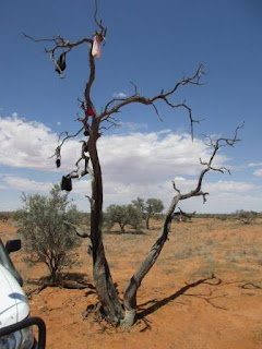
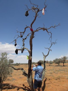
at the ‘Undies Off Tree’ so we could add a pair. Decided to use one of the pair
Rebecca and Clive gave us when we first left. I was saving them for Mt Dare
Hotel but it seems all the pubs have undies, bras or hats hanging off their
rooves so it isn’t anything special any more. Kept the other pair in case we
need them for our Desert Flag! The GPS co-ordinates for the tree are 25 52
10.8S 138 08 00.7E – maybe you can see it on Google Earth!
Steve
found a few more that had blown off so he hooked them back on too.
Clouds
coming from the west. Great view of a salt lake from the crest of a dune.
Wobbly
ride down the west side.
Slow
going at 17km/h as we crawl across lower dunes that are closer together.
Crested
a high dune. Stopped at the top and I walked around to look back along the
ridge to a large salt lake in the south. Good strong SE wind up here.
Last
dune of Qld.
Into
NT though there is no sign or fence, just the National Park ones for those
going east.
Selfie
time.
Continued
west over the next dune for a view of another long salt lake which we will
cross soon. It starts in NT and runs down the border and ends in SA below Qld. It
doesn’t have a name so I will call it 3 State Lake.
Across
the lake – shimmering mirage as we look south. Lots of old boggy strips from
the early travellers. Some were seriously bogged.
Across
the lake to some signs. Hay River Track heads north.
We
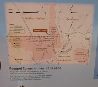
turned left and headed south on the K1 Track which runs down the Qld/NT border
back into Qld then meets the SA border which you can see on this map.
The
Mt Dare sign has nearly been stickered over.
Driving
along the edge of the lake with a big sand ridge beside us. The track is quite
corrugated in parts but people have made new tracks as the lake dries up. I
reckon all the lakes in the desert should be called ‘seasonal’ lakes as it must
be confusing for overseas tourists to see lakes listed in the middle of our
deserts.
Running
down the side of the lake on the Qld/NT border.
Now
we are back in Qld for a bit.
Islands
in the lake.
Reached
the Simpson Desert sign which marks the boundary for Qld and SA. No fence or
sign again. Farewell to Qld for a while. Will turn the clocks back ½ hour when
we pull up. Not going to worry about day light saving time in SA as it won’t
worry us.
Further
along we turned onto the French Line and climbed a dune again as we headed west.
Met another car coming down some lower dunes. We pulled over and he passed us.
Steve asked if he was along, which he replied he was – foreign accent. They
kept going too.
Over
a couple of dunes and Lake Poeppel comes into view.
At
the intersection we turned north-west to head up to Poeppel Corner, the
intersection of Qld, NT & SA.
Poeppel Corner
Augustus Poeppel (pronounced Peppel) started the
Qld-SA border survey in 1878. Timber from waddi trees north of Birdsville and
coolibahs from Eyre Creek were used for mile posts. The position of the first
corner peg was in Lake Poeppel, about 1km west of the present position, but
when the party returned to Adelaide in 1881, they checked their equipment and
found that the chain measure was worn and the survey inaccurate.
Larry Wells was engaged to re-survey the border from a
point near Birdsville. He started in January 1884 and relocated the corner peg
in February, close to the present position. Wells then went on to survey the
NT-Qld border, drawing water from a number of native (mikiri) wells. Although
Charles Winnecki and David Lindsay were both near the corner during the early
1880s, Ted Colson was the next white man to see the corner peg. He found it as
he was returning to his home at Bloods Creek after crossing the desert to
Birdsville in 1936. The original peg was removed by Reg Sprigg during his
survey of the Simpson Desert during the 1960s, and replaced with the present
concrete post.
Interesting
that the plaque at the Info Centre in Birdsville said Poeppel himself went back
to resurvey the line. Maybe that is why the plaque is at the Info Centre not
here!
Read
the information provided.
Steve
checked out all the stickers.
Walked
along the board walk to the replica of the original peg that Poeppel installed
which was put in here in 1989. Steve is a Qld boy through and through.
We
took photo of a bit of us in each state with the 1968 plaque.
Selfie
time again.
We
have seen these Bench Marks along the Canning Stock Route. It was situated
further back into SA. I had looked it up when I was in Cairns but forgot to
write down the info about the difference with them and survey markers.
Originally
Poeppel had placed the peg in the middle of Lake Poeppel.
The
board walk has three paths, one leading into each state. ‘Pat’ is in SA.
Tried
to get into the Visitors’ book but the metal box was stuck shut.
Steve
put on the kettle while I turned the clocks back. Was 3.10 but now it is
2.40pm.
I
read some information off the SA National Parks brochure. Interesting comment
about the dunes being easier to traverse west to east because of the gentler
upsweep of the dunes. Unfortunately after all that traffic it has become a bumpy
upsweep and the east to west is better even if it is steeper. We haven’t had to
bounce up any with speed like we did on the Canning Stock Route.
I
saw the Eyrean Grasswren scoot out from a bush and back again when we were
coming over a dune.
Back
to the turn off and onto the French Line.
French Line
Dr Reg Sprigg was the first man to explore for oil in
the Cooper Basin and as an extension of that search he was engaged to survey
the first line across the Simpson Desert. The first motorised crossing of the
desert, and the first crossing since Madigan, was undertaken by Reg, his wife
and children in 1962. On that occasion Sprigg was leader and navigator of an
investigatory expedition by his company, Geosurveys of Australia Pty Ltd. Dr
Sprigg also undertook the first north-south 4WD traverse 2 years later. The
French Petroleum Company was subsequently asked to undertake the geological
survey, due to their good record in other parts of the world. This line is a
result of that work.
Across
Lake Poeppel – looking north then south.
Up
a dune on the other side then up and down little dunes.
At
the crest of a bigger one, I like the wind swept look.
From
here we have a nice view of Lake Thomas and the straight French Line ahead of
us.
Zoomed
in further along the line.
It
is a slow crawl along over the little sand dunes as it is quite wobbly and we
are rocked back and forwards as we travel along.
Another
wobble down to the north end of Lake Thomas – looking south then north.
Further
along we spotted a painted 44 gallon drum then a Bench Mark by the track as we
headed up a bigger dune.
Continued
rolling over smaller ones again. Took a long video through these lower dunes
until we reached the next dry lake.
Across
that lake and up again. Steve having some fun on some of the bigger dunes as he
is finding it easy to crawl up them and then we have the wobbly ride down the
other side.
Another
wind swept dune. The sky is all clear so hopefully we won’t see any storms
again.
Up
and down more dunes then over another dry lake. Seeing lots of animal tracks,
dingos, lizards and snakes but haven’t spotted anything alive yet.
Up
and down – no flat spots between these smaller dunes to park for the night so
kept going. Different dune country to the east side of the Simpson.
Across
another ‘lake’. More up and down and wobbling slowly along between 5 and 15kph.
The
sun is dropping so we found a place to camp for the night off the track. Quite
windy so we put up the shade cloth to break the wind for the kitchen. I found some
holes and droppings so I think there might have been some rabbits around here.
Our
route for today. We are not too far away from the turn off into Knolls Track.
Steve
got the fire going as the sun started to set. Lovely sunset. A jet flew
overhead heading south.
Still
windy after sunset but we had the fire behind the truck and the shower is
protected so we can enjoy our shower tonight. 8pm it was 30 degrees but the
breeze made it feel cooler. More planes passing over us.
Still
very windy at 10pm. Lightning flashing in the north. Closed the bed door to
keep out the wind.


No comments:
Post a Comment