The
clocks wound back an hour so we now wake up at 6.30pm and it was a chilly 18
degrees. Stuck my head out the door for a couple of photos of the lovely
sunrise colours on the clouds.


Sent
Rick Mitchell happy birthday text as it is his real birthday today. He put his
brother’s date on his facebook page and got heaps of messages last month for
his birthday!!!
Said
farewell to Ian, Kylie & Toby and headed off up the dirt road to Sceale Bay
(pronounced Scale). The campground here has closed. Nice spot with a bit
sweeping beach that apparently is good for surfing – not today though. Captain
Bloomfield named the township Yanera in 1888 after a former Royal Navy
companion of his. About 40 live here permanently and is very popular in the
holidays. A jetty was built in 1910 to load grain and wool to ship to Port
Adelaide. Cargo for farms was also unloaded. The jetty was pulled down in 1972
despite local opposition, the government stating the repairs to the jetty were
too costly.


Back
on the bitumen around Sceale Bay and then passed high white sand dunes.

Turned
off onto the dirt road again to follow the Westall Way Loop Drive.

We
drove in to Tractor Beach campground but didn’t walk in first and some ‘brain’
had put huge rocks along the edge of the road so once in we were committed to
continue. Luckily there was only one other tent camp and we managed to get
around the rock ‘island’ and back into a camp spot.

Made
some lunch then walked down onto the beach. Huge piles of seagrass on the
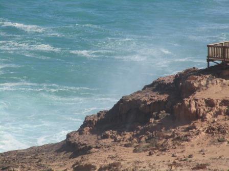
water’s edge. Looking around to High Cliffs.


These
are called seastacks.


Unhooked
and headed off to follow the loop drive. A narrow track lead up to small camp area
where two camps were squeezed in. Zoomed in the entrance to another little bay
further around Tractor Beach.


Another
good view of High Cliffs.


Two
arches below us.


Saw
Ian and Kylie drive pass when we were on top of the cliff. Continued around to the
other side of the cliffs where a camp area used to be but now has been removed
from the list though there are no ‘no camping’ signs around. Nice beach with
rock pools to explore.


Great
watching the waves break.


Steve
found a little rock cairn so added a few more to the pile.

Next
stop was a popular surf beach, Granites, obviously named after the rocks. Nice
rock pool for the kids too though it is 110 steps down to the beach. The
carpark was full with ones looking and a heap down surfing.


Continued
along enjoying the rugged coastline.

Point
Westall was sighted and named by Matthew Flinders on 5th February,
1802, after a landscape artist who was one of his crew on board the
Investigator.

Drove
down the rocky road enjoying the view and the waves crashing on the rocks.


I
walked down to the end of the point. Looking back up around the bay.


Back
up to the main road to the Smooth Pool turnoff.


A
track continued along the coastline where there were heaps off pull off areas
to park and explore and fish.


Lots
of beach houses at Fisherman’s Paradise. Yanerbie is across the bay with the
big sandhills further on shining in the sunshine.

Around
to Yanerbie where there are only a few houses but they are nice flash ones. It
is at the northern end of Sceale Bay on Speed Point.


Drove
across the peninsula to the camp area on Speed Point. Ian and Kylie had just
pulled in here. Nice big bay looking back across to Fisherman’s Paradise.


Had
a chat then headed off onto the point. Looks a good place to fish.


Another
track took us further around the point to the ocean side.

On
the Great Bight side would be good for surf fishing too. Looking across to Cape
Blanche where Sceale Bay township is near.


Leaving
Speed Point, back to the track heading back to Yanerbie.


The
sandhills in the distance.


Back
on the road heading back to the main road, running alongside the sandhills.

Back
to the van. This is why it is called Tractor Beach.

Unfortunately
a few people had come down in their cars and parked around the track blocking
our exit. We hooked up and then noticed another caravanner coming in. Oops. I
asked the people, picnicking on the beach, if they could shift their cars,
which they did and we got out. The other van came around the track so we could
get out the one lane road. I left her to sort out the others as to where she
wanted to park!! Marked that one in the book not to go back to!!
Out
to Sceale Bay Road again and onto Streaky Bay township.

The
actual Streaky Bay is a huge area that goes along way north with Cape Bauer
this end and Point Brown up north. In 1627 Dutchman Peter Nuyts sighted Streaky
Bay from the ship Golden Zeepard. Nearly two centuries later in 1802, Captain
Flinders rediscovered and named it Streaky Bay because of the streaks in the
water across the bay (caused by the reflection of light and seaweed). In 1830
Edward Eyre established a camp area about 3km from Streaky Bay, where he found
water at ‘Cooeyanna’ (Eyre’s Waterhole). In 1840 he commenced his expedition to
Point Bell and Albany, WA. In 2008 Chris Eyre, the great-great-grandson of
Edward Eyre, and a team of friends from the UK, retraced Eyre’s steps in a trek
on foot from Streaky Bay to Eucla (on the WA/SA border). From 1850 to 1860 a
whaling station operated near Point Brown. It is believed that these whalers
were the first Europeans working in the area during that time. From 1854 the
country around Streaky Bay was opened up by pastoralists. Maryvale was the
biggest station comprising of 470 square kilometres. The Maryvale ‘run’ represented
the pick of the grazing land, with water available at a shallow depth. In the
1870s a small oyster factory was established at Smoke House Bay (to the north)
to can oysters for export. The facility was located on the coastline close to
the town of Streaky Bay. The original settlement was named Flinders. As land
was opened up in the district, and the town continued to grow the name was
officially changed to Streaky Bay in 1940. Found a spot near the jetty to park
and unhook the van – right beside a ‘no camping’ sign.

This
is Campbell’s Landing which was a slipway. It was dismantled early in 2006. The
first Streaky Bay store was a hole cut in the cliff near this landing. In 1864
William Campbell covered it with iron and opened for business.

The
‘Carol J’ was a sharking boat, built in 1958 and storm wrecked in 1985.

The
jetty was constructed between 1891 and 1896 and is very popular for fishing.


The
caravan park here makes a good living as it is big and packed. It is a lovely
bay.


Off
in the truck to follow the Cape Bauer Loop Coastal Drive. First stop was Hallys
Beach where a hand-glider had just taken off.

He
has a great view over this beautiful coastline and the Great Australian Bight.


It
is quite windy so hope he can get back to his car ok.


Olive
Island in the distance.

Next
stop was the Whistling Rocks and Blowholes are.


Onto
the 360m long boardwalk though this bit is disappearing under the sand.


This
side is the Whistling Rocks though it sounds more like a Dragon roaring and
then the steam comes out. Got a good video. You can just make out where the
water shoots up through the holes to make the whooshing sounds.


Onto
the platform (which is all wet) to wait for a big wave to rush up into the
tubes. Got a great video then had to dry the camera and our glasses on the
backs of our shirts as the waves hit the rocks and shoot up over us as well.
Hard to get the jet of water from this angle with a photo but the water rushing
over the rock platform was amazing to watch.


The
water worn area.

Great
coastline.

Walked
across to the other viewing platform.


As
the waves hit the rocks, jets of water shot up.


Rhino
Head.

Walked
down to the bottom platform. The blowholes aren’t working and I don’t think
they have as it is all dry here. Maybe the hole collapsed in.


Seaspray
everywhere.


A
big wave crashes in.


Heading
back up to the truck – the dragon let of steam again. Got it.


Out
onto the point of Cape Bauer looking across to Olive Island.


Wandered
around checking out the coastline. I walked to the left first which is heading
south.


Then
back to the truck and to the right which is east.


Continued
along the coast to the east where it is shallower and no longer on the cliffs.
Looking across to The Spit which sticks out into the v-shaped bay of Streaky
Bay township which on the map is called Blanche Port.


At
Moores Boat Ramp a boat is waiting for the tide to come in.

Did
a drive around the town – lovely old Uniting Church, built in 1911.

The
Shepherd’s Hut was one of the original shepherd cottages for Maryvale Station.
This hut was once used as an isolated ward/morgue for the hospital nearby.

Back
to the truck and hooked up again.

Passed
the Powerhouse Museum which opened in 1992 as a museum for over 400 restored
engines.


Next
cheap camp area is at Perlubie Beach. It is on the actual beach so we stopped
and checked it out first. Figured it was fine as the beach was covered in vans
and campers. Steve kept his speed up as he turned and we got around and parked
with no problems. Tides out.


Eba
Island is close by and apparently you can walk to it on a very low tide. Quite
windy too.

Got
settled and I started trying to catch up on my blog. Reading my brochure on
Streaky Bay I saw we missed seeing a replica Great White Shark that was caught
by rod and reel by a young local fisherman in April 1990. The massive shark was
a world record catch weighing 1520kg and more than 5 metres long. It was caught
on a 24kg line after a 5 hour and 15 minute struggle. It is housed at the
Roadhouse.
Of
course the sunset was beautiful. I never get tired of watching it set.


Only
getting ABC on TV so no V8s for us.
Got
the blinds up to look at the stars as it is a bit chilly to be outside.
Could
hear the waves lapping about 9.30 so shone the torch to make sure it wasn’t at
our door. All good.
No comments:
Post a Comment