Nice
sleeping weather, 20 degrees in the van though it is a lot cooler outside with
the wind blowing and it feels like it is coming straight from Antarctica and
overcast too.
Said
goodbye to Tony & Yvonne as they are staying a few more days. Headed back
out the corrugated road rather than risk sinking in the salt pans. Just need to
sit cross-armed!! A bit bouncy!!
Through
Coorabie with its old school site and hall built in 1910. There are lots of the
‘old school site’ signs around these parts. Turn off from here to go to other
beaches on the other side of Cape Nuyts (Wandilla and Cheetima Beaches).

Past
Coorrabie Farm which people can stay at. Back out to the Eyre Highway and Into
Nundroo which has a roadhouse, mechanical shop, accommodation etc. Diesel is
118.9c/l. Lots of motorbikes there. On Sunrise, Sam the Weatherman said he was
going on a ride from Sydney to Perth (I think) across the Nullarbor raising
funds and awareness for Prostate Cancer. Didn’t see Sam though.
Another
golf spot. Drove past all the rubbish on the ground to the ‘hole’ and followed
the road around to the ‘tee’. Wombat Hole, Par 5, 520 meters. Didn’t read the
info (till now) on the bottom about the name of the tee – an old well site used
by the first settlers and the roadhouse for many years.

This
should be interesting as we have to hit off and try and go over a hill and down
to the hole down in those trees somewhere.

I
am using my ‘new’ ball which I found on the beach yesterday. Picked up a few
tees here too as there are lots of rocks so it will be best to get the ball off
the ground.

Steve
gave it a good whack but it went into the grass to the right.


Steve
got me in three shots – well it was three shots over three swings!! My ball
went in the same direction too, into the grass to the right.


We
managed to get it back on course.


Unfortunately
mine landed in a shrub – what’s the penalty – I added on shot!!

Steve
had another big hit and we lost sight of where it landed. He wandered off
trying to find it while I had a few more hits trying to get it up the hill. He
couldn’t find his ball but found another one so hit off from there. When we
walked over the hill, here was his ball, so he went back to his count and hit
off from there. Finally we managed to make it to the hole.


Steve got it in easily. His score was 8.

I
wasn’t so lucky – it kept missing the hole and I ended up on 18.


Back
on the road. 330km to the border – that should take us a week!!

Small
groups of the motorbikes overtook us, giving us a wave as they pass. They are
even on tricycles – funny looking things. We are now in the Yalata Aboriginal
Reserve.


Next
we passed two guys rollerblading along the highway using ski poles to propel
themselves – some people are crazy! Coming towards us were two blokes on
pushbikes.

Beside
us is the Dog Proof (Vermin) Fence which is one of the longest continuous
fences in the world. It was built to keep wild dingoes out of pastoral lands.
Built in 1880s the fence is 5614 kilometres long and starts in Queensland, goes
through New South Wales and through South Australia to the Great Australian
Bight. We then crossed over the grid which is part of the fence as it heads
down to the coast.


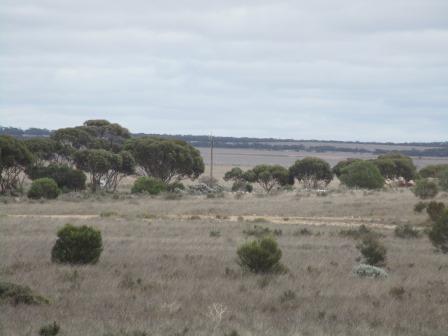
The
road rolls on, up and down little hills.

Passed
the turnoff for the Aboriginal Community of Yalata. Just down the road is one
of the iconic animal signs that the brochures say to get a photo beside.
Unfortunately someone has stolen the camel sign!!

Wonder
why this shirt is nailed to the tree!

All
the tracks have signs advising we need to get permission to enter this land.

Climbed
up to 140m and had a ‘whee’ ride down to 90m at the bottom. I thought the
Nullarbor was flat!!

Only
a few trucks going by today.

Stopped
for lunch at the 222km Peg Rest Area. Plenty of room with shady trees well off
the road.
Over
the hill and this is what I call flat.


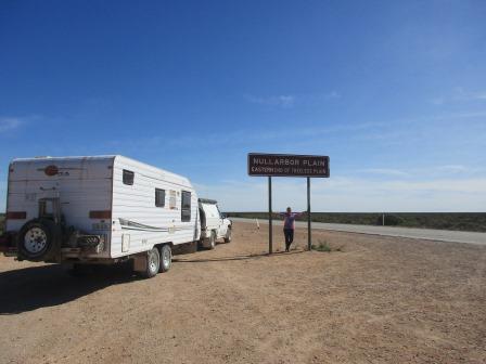
Then
we passed the sign ‘Nullarbor Plain’.

Didn’t
stop as there was a truck behind us. We could see a tower which is part of the
Bight Centre.

Turned
off and drove the 11km down to the Head of Bight Centre.

It
is open all year but during the whale season (May to September) it costs more
to visit. We paid $7 each (wouldn’t take National Seniors card!!) to walk down
the boardwalk. It is owned by the Aboriginal Lands Trust but is run by two
‘white’ people who have been doing so for the last 7 years.
Inside
was some information boards and usual tourist stuff to buy.


The
chap said the whales arrive early May and they come right up to the cliffs with
their young. They give birth further out so their placentas etc wash away
quickly and so sharks don’t come to close to the cliffs after their young. They
have had up to 170 whales in the bay – would be an amazing sight.

Outside
were bones of a juvenile Humpback Whale which washed up dead on the beach near
Twin Rocks in March 2009.

Followed
the path down to the boardwalk – the Centre is set well back. More info about
the Marine Park.


Went
to the right to the lookout – The Bunda Cliffs are spectacular. The sun, of
course, goes over the cliffs left to right so we don’t get the sunshine onto
the cliff faces.


Turning
the other way we look over white sand dunes which probably go all the way down
to Cape Nuyts where we were yesterday.


Back
up to the top of the boardwalk, looking over the Great Australian Bight. No
land in front of us until we hit Antarctica!! Luckily we have a perfect day,
the sky is blue, the sea is calm – all we needed were some whales!!


Cute
little lizard.

The
Giant Snake story about how Twin Rocks were formed. I can only see one rock.


Down
to the bottom of the boardwalk where there is protected whale viewing spot.
Steve thinks he sees one!!


Back
up the boardwalk.


Little
tubby tries to run away quickly – nature wasn’t nice giving him such short
legs.

Back
through the centre and into the car park where there is a picnic shelter with a
lot more information. Shame they didn’t get the spelling right – plateau!!


Southern
Right Whale – I read somewhere else they were called Right Whales as they were
the right ones for good oil etc.


If
they didn’t print such fancy tickets they wouldn’t have to charge so much!!
Good photo though.

Back
out to the old Centre where a big gate stops tourists from entering after
hours. It is now a free camp area.

On
the fence is a whale telling the story of the Anangu aborigines and what
happened to them.


Drove
back a couple of kilometres to the Nullarbor sign.


14
kilometres on we left the Aboriginal Lands and entered the Nullarbor National
Park. The Roadhouse is at the start of it. Another golf spot. A couple of old
wagons on each entrance.


Steve
parked beside an animal sign – it has its camel sign. By the way we haven’t
seen one animal on the roadside – which is a good thing, though there hasn’t
been any roadkill either – don’t think we will buy a burger here!!

Checked
out the huge whale which the aborigines called Kondole.


Lots
of info on the roadhouse walls.


Why
it costs so much here – diesel is 158.9 c/l.


This
is the first bicycle ridden by a helmeted cyclist to cross the Nullarbor in
1962.

Steve
was rushing into the pub till he read the last bit!!

No
topless barmaids but the murals were great.


I
asked about the caves nearby and was given a mud map. Around the white posts
then out to the windmill and follow the markers from there – about 10km. He
advised us to leave the van behind so we unhooked and headed off along the
rocky dirt track which used to be the old Eyre Highway.

Turned
right to Robert’s Well. This was once a big sheep station. They put in the
roadhouse years ago to look after the poor travellers crossing the Nullarbor on
the rough dirt road from the 40s to 70s. The new highway was bitumined in 1976.


Huge
well. No snakes in this one.


Passed
the old stock yards.

Then
the horse tank.


Lots
of wombat holes along the way. Found some fresh droppings but no wombats.


Next
was No. 1 Bore – it goes a long way down. The old reel used to wind up the
water bucket.


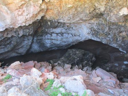
Murrawijinie
Caves was something else. Just big holes in the ground. I wonder how many sheep
they lost down there.


I
walked around to the other side. Steve was standing above a huge cavern. Glad
he has lost some weight!!


Continued
walking around the rim taking photos.


A
bit of information about the three caves here. There are lots all over the
Nullarbor – will have to watch where we step!!


Drove
down the road a bit more to Cave 2. Walked around it. A long way down if that
rock breaks.


Cave
3 had lots of pretty plants around the opening.


We
could walk down into this one. The photos don’t show the depth – there was
plenty of room on the floor. Someone had been camping down there as there was a
fireplace.


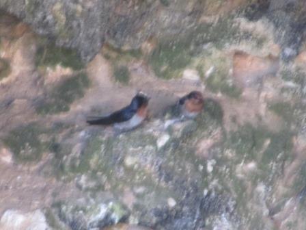
Two
round holes above us.

Cute
little swallows like to nest here.
A
bit of limestone formations.

Back
up on top looking down the two round holes – Steve found a good bit of timber
like a nulla nulla.

Apparently
you can camp here too but it isn’t widely advertised.

Headed
back – a lonely tree on the ‘treeless’ plain.

Fuelled
up. I gave the mud map back and chatted with the young attendant. He has been
working here for 3 months and is going to go back to Adelaide and pack up his
stuff and come back for another 6 months. He just loves the open skies and
meeting all the people who stop at the roadhouse. It is privately owned with 2 managers and 12
staff. The old homestead is their
quarters. I commented about the lack of trucks today and he said they would
have stayed off the road because of the 400 or so motorbikes doing the charity
ride. I asked about the golf course and
he said the worst someone had owned up to is 27 for the Par 5 – I said I would
probably beat that!!
Hooked up the van and parked in the van park near the hole. Walked up to the tee which is on the way to the homestead.

Halfway
– looking back on the roadhouse.

Dingo’s
Den. The hole is down that way, curve around the post and head for the van park
and our van. $20 per night for unpowered, $30 for power.


I
hit off well but Steve headed straight into the rough. My next hit I rolled
over the wombat holes – no sand bunkers here – if you go down the wombat hole
it is all over!! Luckily I went over the other side.


Another
obstacle is the barbed-wire lying around with a few bones scattered here and
there!!


Didn’t
make it onto the fairway but I can see it clearly – on the airstrip!! Planes
and helicopters land here and also the RFDS. They used to land at Yalata
Community to run a clinic there but now land here and drive after their plane
was vandalised at the Community Airstrip!! A few more people going to have a
hit.

Onto
the green, I went straight in for a score of 18 but Steve couldn’t get it in
the hole this time and ended up on 22.

We
need one of these.

Some
more good murals on the shelter shed for the van park.


Making
use of all the old bits and pieces.


Stopped
for a photo of the animal sign, with a camel one.

Getting
late so we headed down the road 20km to the 164k Peg Rest Area (haven’t found
any pegs!!) Plenty of room well off the road. Another car came in and parked in
amongst the trees and a motorhome went further over into the trees.


Bit
chilly as I waited for the sun to set.


Quiet
night, no animals around. Thousands of stars overhead – shame it’s too cold to
be outside and we still can’t have fires yet till the 15th.
No comments:
Post a Comment