Ran
the diesel heater all night to see if that would help with the freezing up
problem but at 5.30 I heard the tick tick of the fuel pump and then it shut
down. It was 10 degrees in the van so just went back to bed. At 7am it was 5
degrees in the van and -7 degrees outside – WOW! The frost was thicker but I
just popped my head out for a minute for a couple of photos.
The
sun was just coming up but the colour didn’t come out in the photo.
The
other van put on their generator and I noticed their poor dog was outside –
Really!! 8am and it had dropped to 2.6 degrees in the van but warmed up with
the sun to -4.2 degrees outside!! I thought this was dripping off the roof
vents but it was still frozen.
Steve
put on our genie and warmed up the van to 7 degrees by 9am while it had warmed
up to 2.5 degrees outside. Getting water again through the pipes.
10am
and the heater is working again so Steve coloured by hair. Texted Alan to wish
him a happy birthday. Wispy clouds are coming over. Malcolm rang to see how we
were faring with the cold weather. He said that in ‘winter’ the conditioner is
automatically added to the diesel but as it was only autumn they hadn’t added
it yet!! This is very unseasonal weather apparently!!
Had
lunch then headed off to explore Poatina area. Passed St Andrews Inn at
Cleveland which is one of the finest examples of an original coaching inn and
has been welcoming travellers for over 150 years.
Turned
off the main road at Powrama and were amazed to see emus. Not the extinct
Tasmania ones though!! Certainly that was one animal we didn’t expect to see.
Heading
towards Mt Blackwood where there is a lookout.
Another
silhouette in a front yard of a property and then a golfer (which I missed).
Zoomed
in on the penstocks coming down the mountain to the Poatina Power Station.
We
were at 220m elevation and then started the climb up the mountain. After 2km we
turned off to Poatina Village at 330m. Originally, Hydro workers lived here
while building the Great Lake Power Scheme. Today it provides friendly
accommodation with shops, tennis, restaurant and boasts it has the highest golf
course in Tasmania, all with a spectacular view. Should have come yesterday as
the view is hazy today.
Don’t
think anyone will be using the pool as it is quite cold up here!!
The
power lines head up the mountain beside the village.
The
glass monument was made from 80% recycled glass in 2004 and it portrays the
past, present and future stories of the Village and celebrates the age old
proverb that ‘it takes a community to raise a child’. Unfortunately it was
damaged in a severe windstorm in 2010 and they are fundraising to fix it all
up. The info sign was all cracked too that we couldn’t read it. They used lots
of things from around the village.
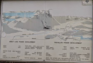
Info
about the Hydro Power Scheme.
We
didn’t see any sign for the lookout so kept driving to the top where we came
out at Central Plateau at one end of the Great Lake (1150m). Looking up at the
barren rock formations.
A
group of flash cars going for a fast drive back down the range.
Turned
off to Cramps Bay which is another trout fishing hut township.
Looking
across the bay to the other side of Great Lake where we had been back in
December. The Lake is located 1034m above sea level. It was one of Australia’s
largest natural freshwater lake systems prior to its initial damming in 1916.
When full, the lake has the capacity to cover 17,610 hectares and hold 3, 178
million cubic metres of water. The water used to be used by the Shannon and
Waddamanna Power Stations at the south end of the lake then they changed it and
now make the water go from the north, thru a tunnel in the Great Western Tiers
and down to Poatina Power Station that we passed on the way up.
The
water level is very low.
The
broken up rocks, from the freeze/thaw conditons, are all around here.
Headed
back down the range to try and find the lookout. Millers Bluff 1210m.
Found
the sign on this side and we drove up a road off the range. There are lots of
roads off here with boom gates and this one said ‘boom gate ahead’ and there
are no other ‘look out signs’. The boom gate was closed but we could park next
to the Telstra Tower (950m). Great view up at Mt Blackwood.
Great
views.
Zoomed
in on the Y’s and it was a dam we passed but not sure what the Ys are for.
Made
a cuppa then walked up the road passed the boom gate, which said ‘temporarily
closed, by Hydro Tas’. This is where an
adit was dug and obviously all the dirt was piled up here from the tunnel. You
can see the old timber frames to hold up the dirt etc.
As
we walked up we looked down on the rows of power lines heading off from the
power station below us.
Another
shot of the rocks and the entrance to the adit.
This
area is listed as a camp for Big Rigs, m/homes and vans in my book and yes it
would have been a great spot except the road was closed!! Fabulous view though
we should have come yesterday when it was a clearer day. All the smoke haze
from everyone’s chimneys warming up their homes.
The
foundations are still here from when they were building the tunnel etc. Railway
tracks obviously used to truck the dirt from the tunnel to where it was piled
up down the road.
Found
the toilet block.
The
entrance to the Headrace Adit.
Peered
in through the grill.
The
pipework was sucking air into the tunnel.
A
natural waterfall area goes down through the railway line grill to a pipe that
goes under the road. There is a lot of water flowing out of the tunnel, under
the pipework in a gutter, and that goes into this pipe and out the other side
and down the mountain.
Back
down the range to the Poatina Power Station, life house and transformer yard
(380m). Another boom gate. Obviously
these places were open to the public to view (I have a brochure saying ‘walk to
the penstock, etc’ but nowadays they only promote certain ones. The Great Lake
Power Development – At this point, two vertical shafts lead down to the
underground power station. One shaft contains the steel pipeline conveying the
water to drive the turbines in the power station, the other shaft contains a
lift ventilating ducts and electrical bus bars that convey the power generated
to the transformer yard. The power station houses six 50,000 kilowatt generators,
each driven by a Pelton Turbine, operating under a static head of 2,729 feet.
The total capacity of the six turbines is 400,000 horsepower.
Quite
an impressive view.
Looking
at the railway line, it looks like this piece of the penstock could be slid sidewards.
Steve
noticed that a railway line ran all the way up the hill beside the penstocks –
maybe it is how they got them into place originally.
Zoomed
in to the top – goes straight down, must have been scary working on this
project.
Back
to the bottom and we slowed down to get ready for a photo in case the ‘black
things’ that we saw at this wood pile were out again. Steve thought they looked
like little Tassie Devils but they weren’t out again!!
Last
fuzzy shot back at Mt Blackwood and the penstocks.
Decided
to go back via one of the back roads. More and more sheep with a few tree farms
along the way. A cute little church in the middle of nowhere.
Another
thing we weren’t expecting was a Bauxite mine – the sign said Bald Hill Bauxite
Project.
It
was 4.30 when we got back and starting to get very cold. We picked up the van
and headed round to the other RV Stop to fill up with water and dump the
toilet. Sounds funny that but there is a separate tap to fill up fresh water,
well away from the dump point!! At 5 the sun was going down and so was the
temperature. We drove 11km back up the highway to Conara to the roadsite camp
we checked out today. Parked the van and got the heater going. It is cloudier
so we mightn’t freeze in the morning. Ian and Cherie had texted that they got
some winter diesel conditioner from Super Cheap so will get some tomorrow.
Erica
rang for a chat.


No comments:
Post a Comment