Another
bleak morning. 6.30am it was 7.7 degrees in the van so on with the heater. At
8am I put the thermometer outside and it was only 5.2 degrees but nice inside
at 16.7 degrees. A misty fog has settled over the lake again.
At
9.30am Steve ventured outside to pack up and it was only 8 degrees. Shame I had
to stay inside with the heater on to do my packing up!! Texted Malcolm to say
we will be at the Lee Van Park on Monday!! Steve then rang the radiator chap to
arrange to pick up our radiator.
Back
onto the main highway again with 110k/h speed limit. Heavy mist.
Further
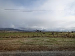
along the sky is looking brighter.
Turned
off the highway into the little locality of Tunbridge (230m) where there is a
convict-built bridge over the Blackman’s River which is the oldest timber
single span bridge in Australia. Of course we are too heavy to cross over it so
Steve turned the van around and I walked down for a look. Cute little homes
here.
An
old wagon near a house that has a very old sign about being the birthplace of a
couple of race horses.
The
Blackman River Bridge.
An
old stage coach and information at the park. Boy it would have been a very busy
place back in the mid 1800s.
One
of the staging inns is the Tunbridge Wells Inn, first licenced in 1833-34.
Complete
with cute family and someone waving from the top window.
Through
Ross, will check that out this afternoon. Into Campbell Town and parked at King
Street Oval which is a 24 hour RV Stop.
It
is next to the Elizabeth River which has a swimming pool concreted into it
years ago but it isn’t used nowadays.
The
little bit of sunshine has disappeared behind the clouds again so ran the
generator while we had our lunch to charge up the batteries and my laptop.
Drove
back to Ross (180m), lovely avenue of elm trees.
Parked
at the Info Centre which is also the Tasmania Wool Centre. Lots of information
about the wool industry with displays showing the different types of wool that
we could touch. Land was granted in this district from 1821 and settlers
capitalised on the ideal wool growing conditions in the area. Another section
about the historic bridge, the Female Factory, a prestigious school and war displays.
Didn’t use the camera in there.
Walked
to the intersection with the four interesting street corners:
“Salvation”
– the Catholic Church (c1920);
“Temptation”
– Man O’ Ross Hotel (c1835);
“Recreation”
- the Town Hall (1891);
“Damnation”
– the old Gaol (now a residence).
Headed
towards the historic bridge past the army barracks (c1829).
The
historic sandstone Ross Bridge, over the Macquarie River, was built in 1836 and
is the third oldest bridge still in use in Australia. The bridge was built by
two convict stonemasons, Daniel Herbert and James Colbeck and a gang of convict
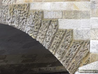
labourers. Daniel created the unique carvings on the side of the bridge. The
two stonemasons were given their freedom after they completed the bridge.
Zoomed
in on the carvings of the first 2 arches.
Engraved
on the side of the bridge.
Near
where I was standing looking up at the bridge was a sculpture made to celebrate
Valentine’s Day.
At
the entrance to the path was a stone in the ground which was half covered up –
so I cleared it – hence the sculpture.
Walked
over the bridge. The stone is carved with the distance to Hobart on one side
and Launceston on the other. Notice they
put a v instead of a u in Launceston.
On
the top of the bridge rails was a metal brace stamped with the convict symbol.
Lovely
view of the Macquarie River which flows all the way to near Launceston.
Zoomed
in on the 3rd arch’s carvings.
Back over the bridge then down to the other side. There is still sandstone along the water’s edge.
The
Historic Engineering plaque.
Followed
the map to the original stables for military garrison horses. It was built with
the sandstone rock as the back wall. Smelt very horsey too.
They
had carved the stone to create the food/water trough for the horses at the
bottom.
Walked
up the hill through the cute and practical sheep-proof gates.
Looking
south over all the sheep pastures.
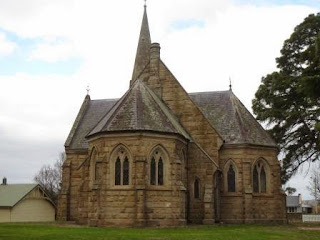
The
rear of the Uniting Church (c1885).
Around
the side was a plaque and stones from the old chapel.
Back
to the truck and the original headquarters of the Army Ordnance Corps (c1836).
Across
the road is information about the 42 degrees south latitude which runs across
near here and that Ross is the only town of any size that is close to it.
Tasmania was divided in two by the 42 degrees line because the two officers in
charge wouldn’t work together so they were given a region each – north and
south. By 1812 though it was governed by one person as a whole island.
Took
our GPS to this marker to compare and ours gives a different location for these
co-ordinates so I am going to get someone to check it out in Launceston.
Explains why it gets confused at times.
Neat
gutters.
Continued
down Church Street. The Scotch Thistle Inn (c1831) is now a private residence.
The
Ross Post Office was built in 1888.
They
have lots of goodies for sale that you would think it is a gift shop rather
than a post office. We had a good laugh at these. The rabbit mittens were nice
and soft too.
Cute
little mail box and it even has a sign saying it is real.
Captain
Samuels Cottage (c1830) is a cute B&B though timber over the windows looks
a bit wonky.
Another
one converted to accommodation (c1850).
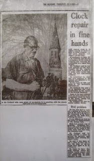
St
John’s Anglican Church (1838) has a clock in the tower.
Back
down the other side we found some info about the clock. A 1976 news article
that said the clock had been installed in 1869 and the chap was trying to
restore it.
Another
article was about Horton College (1855 to 1894) which was a very prestigious
school back down the highway. It was
demolished in 1920-21 and the one million locally made bricks and the timber
were used in other buildings throughout Tasmania. The lady at Colebrook had
mentioned that all that was left was the front door archway. We saw it in the
middle of a paddock as we headed up here but I wasn’t ready with the camera. In
the Wool Centre there was more info about it.
Back
to the truck and we drove around to the site of the Ross Convict Female Factory
(c1848-1854). Only the Commandants cottage is left.
Wandered
over the site to read all the info boards.
Only
a bit of the foundations of the buildings that housed the convicts is left.
We
headed into the Commandant’s cottage. Info about the changes to the cottage –
this used to be a window before the extra rooms were added on.
Found
out the meaning of the convict symbol – it actually means it is government
owned which of course the convicts were.
Timeline
of the site:
C1812
– Garrison established at river ford.
1821
– The town of Ross proclaimed.
1831
– Brick and thatch huts built on the site for convict gangs employed in public
works.
1832
– Sale of land to settlers at Ross.
1841
– Site commenced use as male probation station housing chain-gangs working on
the Hobart-Launceston road.
1847
– Expansion of buildings for female convicts.
1848
– Women move into the Factory.
1853
– End of convict transportation from Britain.
1854
– Closure of Female Factory; local Catholic Church allowed to use the Chapel.
1855
– Factory handed over to Police Department, vacant except for caretaker.
1862
– A proposal to turn Factory into boys reformatory, but not proceeded with.
1875
– Factory used by contractors working on mail railway line; buildings fall into
disrepair.
1879
– Proposed division and sale of Factory into lots, but not proceeded with.
1894
– Factory site reserved for Municipality of Ross.
1895
– Cottage converted for use by Superintendent of Police (extended using stone
from old factory buildings).
C1897
– Remaining Factory buildings demolished.
1907
– Police resident at cottage.
1938
– Mr L Knowles resident at cottage.
1974
– Death of Mr Knowles.
1980
– Management of site transferred to National Parks & Wildlife Service;
declaration of Ross Female Convict Station Historic Site.
A
site map.
Information
about the staff that worked at the Factory and what they were expected to do.
Another
room was about the archaeology of the site in 1997. This explains the symbols
on the Army Ordnance Corps building in town - it is the insignia of his
Majesty’s Army.
In
2007 archaeologists explored the area.
A
solitary cell block excavation.
Crime
class dormitory showing drains, foundations and the muster yard surface. Note
the drains run parallel to the foundations of the walls but then turn out to
surround which is believed to be an entrance porch.
Another
room was all about the female convicts, what they ate and wore etc.
Headed
back over the Ross Bridge and onto the highway. Looks like clear sky to the
north.
Back
to the van at 4.30 and it is only 8.9 degrees outside – no wonder we are
freezing. Put the heater on and made another cuppa. Quiet afternoon doing my
blog and watching TV.


No comments:
Post a Comment