Woke
to the lovely call of whistling kites. 6am 9.7 degrees, clear sky. Then a
chorus by the kookaburras – just love their laugh. Lots of birds around here.
The chap beside us must be a ‘twitter’ as he has a huge lens on his camera and
sat down by the water from early in the morning looking at the birds.
7am
it reached 12 degrees so it was ok to get up now. The white cockatoos moved in
with their racket. We packed up and drove up the road a bit then turned into
Spring Creek Track. Our brochures say it is a 53km, 2.5 – 3hr drive in and
restricted to 4WDs only and only single-axle off-road camper-trailers allowed.
Must be rough. There is a caravan park one kilometre in where people can leave
their vans etc. The helicopter was there too for those who just want the flight
over the landscape. Jeff brought me a brochure for here and the Horizontal
Falls. $299 for 18 minute flight here so I think I will save the money as we
definitely want to do the falls and you can walk to them. They will cost us a
penny or two but will be worth it.
First
part was a bit bumpy but we have definitely been on worst. We are travelling
through Mabel Downs Station so we are not permitted to go off the track or camp
anywhere until we reach the national park. Stopped at the Information area –
looks good with the walls shaped like the ‘Domes’.
Oh
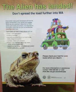
no the dreaded cane toad – won’t tell anyone we are from Cairns.
Continued
on the formed road which was a bit corrugated but fine. A big 4WD tour bus came
past – glad we had the windows up and the a/c on.
Through
hills and spinifex just like Halls Creek. Lots of recently burnt areas too.
Signs on the tracks saying ‘no entry’. Lots of vehicles coming out, many towing
campers and small vans so can’t be too bad. Across a few dry creeks. The locals
were hogging the track and didn’t want to get off it. Well it is their station
I suppose.
Bit
of water in this creek crossing.
Two
wet crossings as we crossed Calico Spring twice.
Weaving
through some very high hills then around the end of a long ridge. Into another
wet creek and onto open ground between tall hills. Across the wide and rocky
Frank River with a couple of little pools.
Left
the pastoral land and heading into the National Park – only took us an hour to
here so they have obviously improved the road a lot. We would have brought our
van in here – slowly of course.
Purnululu is the name given
to the sandstone area by the Aboriginal people and covers an area of almost
240,000 hectares. The Bungle Bungle Range has been a tourist destination since
1983 and was granted World Heritage status in 2003.The Range is estimated to be
360 million years old and it rises over 200 metres high, formed during the
Devonian age, carved over 20 million years through erosional forces. The Bungle
Bungle Range is renowned for its striking sandstone domes, striped with orange
and grey bands - the grey banding is
formed by cyanobacteria, the orange banding is the result of oxidised iron
compounds within the layers.
Up
and down more hills and through more burnt areas. First view of the Bungle
Bungle Range as we crest the hill.
Another
20 minutes and we reached the Information Centre. Paid for two nights in the
Kurrajong Camp ground on the north side. The staff are from Kununurra and work
a 10 day rotation. Takes them 5 hours to go home.
We
continued on then turned left at the t-intersection – good signage.
Passed the
lookout area – good for sunset apparently and continued up a bit further into
the campground. Only half is open at the moment – they have 106 campsites and
there is also the other campground on the southern side. Very popular
especially in June/July.
Chose
a spot and put out our mat and table and the washing that had been getting a
good tumble in the ‘washing machine’ to mark our spot. Filled up the solar
shower with the bore water and laid it out so we can have a warm shower later
as no fires are allowed in the National Park now – used to according to the
maps etc. A few other camper-trailers were here. Nice toilet and good bore
water is available.
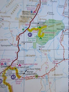
Our
map of today’s travel.
Had
a cuppa then headed north to explore. We received a great map and some great
aerial photos.
I
drove Steve made wanting to stop and take photos but it was pretty impressive.
Turned
off into Bloodwoods carpark. There are two walks from here. Mini Palms Gorge
and Hoemstead Valley. The one to Mini also joins the Escarpment Walk around to
Echidna Chasm.
We
walked up to the little lookout first. Lots of river stone rock up here so you
can imagine how that was all a river bed and eroded away slowly.
Great
view too. You can see where waterfalls would cascade during the wet. Took a
video.
A
fire has been through here recently – the toilets got a bit warm. Made some
lunch and sat at the big shade-cloth covered picnic tables.
We
decided to do the Mini Palms trail first. Filled up Steve’s camelback and
grabbed some apples and our walking sticks. There were a few plaques along the
way.
Looks
like a good cave under there.
Turned
off the Escarpment Trail and headed in towards palms in a gorge.
Up
a creek bed. That’s hard walking over those river stones.
The
hills are towering over us now. I zoomed in on an anthill right up on the top –
amazing.
We
smelt this tree before we got here – so sweet with honey and the bees like it
too.
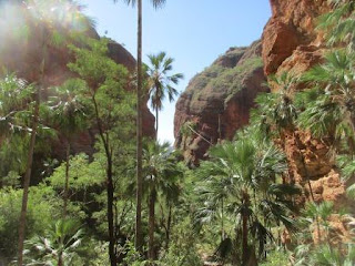
Very
pleasant walk up the creek into the gorge.
You
can see the river stone on the sides of the hills and in big rocks in the creek
bed.
Don’t
think he took the right track here – not so squeezy but we made it through.
Climbed
up and down and around some more boulders.
Straight
up.
Slow
process with me stopping to photograph so much but it was beautiful.
Zoomed
in on the crack as palm trees were growing out of it.
This
tree fell over but hasn’t died so just bent at the other end and started upward
again.
Stopped
to read the sign about the palms. There is a musty sandalwood scent as we walk
along – will have to ask someone if it is from the palms.
Good
view back through the gorge.
Up
some stairs over bigger boulders.
Looking
forward as the sun is shining on the sandstone wall then back down the gorge.
A
few more stairs up onto the top of another big boulder to a platform (installed
2015) and the end of the walk. Lovely view into the gorge. We sat and enjoyed
the view while we ate our apples. Took a video.
The
colour changed on the wall as the sun moved across the opening.
Another
couple with two young boys arrived – that was the end of the quiet. They are
doing a 14 week half lap of Australia and are 8 weeks in and loving it.
Headed
back down – zoomed in on the view back out.
Back
to the Escarpment Trail and we had noticed it said Frog Hole 1.1km further on
so we continued on for a look.
More
information then across another creek that leads up to another gorge. A lot of
the creeks have a sign saying cultural area – no access but we haven’t read any
information about the cultural significance of these areas.
More
info. Lots of pretty wattle in bloom.
Arrived
at another creek where there was a picnic table and toilet – the ground around
it all recently burnt.
No
sign about a Frog Hole so we walked up the creek to see if we could find it.
Didn’t find it but the views were great. Interesting waterfall up there.
I
spotted some red stuff on the ground and realised it was a Bloodwood bleeding.
Getting
some good exercise for more ice cream tonight. Back to the truck for a cold
drink.
Back
to our camp spot – washing all dry. Drove around to Kungkalanayi Lookout to
wait for sunset. A tour group had just arrived and were heading up the spinifex
covered hill too.
They
went left. I saw some seats on top of the hill to the right so we headed there.
Fabulous view. Took a video before more people started coming up.
There
is a 500 million year old limestone ridge in front of the Bungle escarpment.
Took
more photos and another video as the sun dropped.
Turned
west to capture the sun disappearing behind the hills.
Spotted
the moon over head.
The
sun is down so I panned around the Bungles Escarpment.
You
can see the rolling hills on this western and southern side of the lookout now.
Chatted
with a couple from Melbourne while we were enjoying the view then decided we
had better head down since no one brought a torch.
Back
to camp for a warm shower heated by the sun.
Played
some Skipbo before dinner. Cooling off quickly 7pm, 19 degrees. A few more
games after dinner then some soft-serve ice cream. Hasn’t melted, just not as
hard as in a normal freezer.
Finished
off with a coffee and another game of Skipbo before we got too cold sitting
outside without a fire to warm us. All quiet in the campground so we went off
to bed too.


No comments:
Post a Comment