27
degrees predicted today with showers in the afternoon – amazing how it drops so
quickly. Rang Mum & Dad then Erica & Terry – all good. Worked on my blog
– so many photos again!! Steve pottered around.
While
having lunch we watched the beginning of Storm Boy shot in the Coorong, SA. Mr
Percival, Mr Proud and Mr Ponder the pelicans. ‘Finger Bone’ told the story of
the pelican – a man carrying a canoe on his head met a duck and fell in love
and married her – interesting!
Headed
back up into the Perth Hills – clouds are coming in from the west. First stop
was Lesmurdie Falls. A bit of info and a nice photo of the falls with lots of
water. As it is summer there won’t be much coming over now. Lots of walks to
do.
At
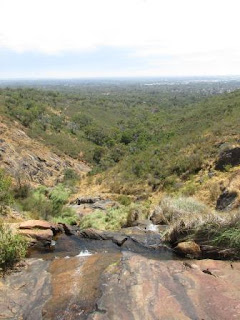
the top of the falls there is still a little water coming over the falls.
Walked
down to the next lookout. Info about the Darling Scarp – the hills are part of
the Darling Ranges.
Some
people were down at the bottom of the falls.
Zoomed
in on the city though it is hazy and the clouds are closing in – very windy
too.
Walked
back then took the path to Shoulder Lookout. It was very narrow and overgrown
and heading downhill so we enjoyed the view from the top and headed back to the
truck.
We
are in a National Park and across the road are all the hillside homes – they
have great views.
Headed
into Kalamunda – cute sculpture in the roundabout.
Turned
off and headed out to Mundaring Weir. Stopped at the first lookout and walked
down to cross the top of the wall.
The
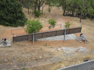
pipeline used to top up the weir.
The
spillway.
One
of the gates to raise the height of the dam wall – it would slot in here.
Looking
down to the old pump station beside the Helena River which is dry now.
Lovely
view across the water of Lake CY O’Connor.
The
Upper Valve House controlled the water to No. 1 Pump Station. It was designed
with 3 intake pipes at different levels. The pipe chosen to take the water from
the dam depended on water quality as well as water levels. The original
controls for the intake are outside now on the walkway. New pipes were put in
when the wall was raised. As a tribute to the original scheme the valve house
was reconstructed on the raised wall to the original detail.
New
pipes come out from the bottom of the wall.
Walked
across the wall to more information.
Looking
back across the wall.
A
few people were peering down into the water so we stopped to check it out. The
chap was pointing out the freshwater yabbies. There is a very limited season (1
month) to catch them in normal creeks and it is totally banned here.
Drove
down to below the dam wall for a cuppa. Some more info on the families living
here as the dam was built.
We
won’t be hanging around to see the water come over the wall as they maintain
the water level and it last flowed in 1996. So obviously the Helena River
doesn’t flow anymore either.
We
have been to the end of this pipeline and now we are at the beginning of it. A
new station is downstream.
Walked
around checking out some more information signs – hate these metal ones, hard
to read and photograph on a sunny day. All the walks start from here.
People
walking across the top of the dam wall.
Little
house which held the valves that controlled the water into the pump station.
Got
our exercise up the stairs that took us to where the zig zag railway was to
bring materials etc to build the wall.
Another
board about damming the river.
Back
to the truck and around to the other side then up the hill to Mundaring
township. The hotel was built in 1896.
Found
the main entrance at the rose garden.
Info
about the forests and precious water.
Statue
of a Weir Worker 1902 (made 2013).
CY
O’Connor Memorial.
This
dam and its pipelines is an internationally recognised engineering achievement.
A
glass-covered wall of lots of information and photos. The wall was thickened
and raised in 1951.
Water
flowing over the original wall.
The
Premier of WA, Sir John Forrest, opening of the valve on 24 Jan, 1903 to mark
the opening of the Goldfields Water Supply Scheme at Coolgardie.
Fabulous
photo of the original wall and the lake.
The
new wall being constructed over the old wall.
2001
where the water flows.
Looking
back at the wall we think the steps were where the old wall top used to be as
the new wall raised it up 10 metres.
Back
down the road passing the pipes taking the water over the Darling Ranges and on
to the other pumping stations to get it to Kalgoorlie etc.
Oops
someone didn’t have a good day.
Turned
off to check out another lookout. Looks like the fire season has started and is
still smouldering.
Lots
of black boys – grass trees around here.
Fabulous
view from here.
Zoomed
in on the pipes heading up over the range.
Back
to Kalamunda where we passed the Zig Zag Cultural Centre and a history village
but it was too late to go in. We were heading to the Zig Zag Scenic Drive which
we presumed was a railway line up the range. Very narrow and only one way and
obviously used to do burnouts!! Sharp u-turns – Steve wondered how a train got
around the bends. I googled it when we got back. (The Zig Zag Scenic Drive was
originally a section of railway line built to transport timber from the top of
the escarpment down to the commercial centre of Midland. The line was laid in
1903, and required a series of switching points, known as Zig Zags, to shunt
trains up and down the steep gradient of the Darling Scarp. The timber industry
eventually closed down, and the rails were removed in 1952. Bitumen replaced
the rails and the Zig Zag became a 3km scenic road which is very narrow and has
many hairpin turns so it only one way going down to the plain.)
The
clouds are dark and looking like rain over the airport and the city.
Back
to the van where it is dark and gloomy but no rain yet.
After
dinner a few drops of rain started to fall but nothing like we are used to.
The
wind stopped at bedtime and it got quite humid.


No comments:
Post a Comment