16
degrees with a clear sky and no wind. Heater on early this morning. On the
weather it said it was 6 degrees early this morning in Kingscote so no wonder
we are cold.
Went
down to the jetty to try out our squid jigs as the sea was calm and clear which
the squid as supposed to prefer. Unfortunately no one told the squid. Saw a
sting ray swim by though.
Had
a cuppa in the sunshine then packed up to do the big drive (35km) to American
River, which is neither a river or American. American sealers arrived there and
thought it was a river, hence the name. They made a ship while there were here
called the ‘Independence’.

All
the animals are good friends around here sharing their grass.

Down
to the water and the Council campground. Very nice.


The
tide is out at the moment. The inlet (river) goes a long way to the south.


As
the sun is out and the sky was reasonably clear we headed off to check out the
lookout on top of Prospect Hill which is down on the neck between the large
part of the island and Dudley Peninsula.

First
stop though was Muston Lookout above American River.


Prospect Hill in the distance.


Unfortunately
the trees have grown up so I climbed up on the posts with the boys holding me
so I could get some good photos. Leanne
got the rear end shot!!

Nice
straight bit of road.

Now
for some exercise, 512 steps up Prospect Hill which was originally called Mount
Thisby. Matthew Flinders climbed it in 1802 with no steps so we shouldn’t
complain.


Not
nicely spaced either, some wide apart, others very close together and some
covered in sand. A
few more stairs.

Time
for a rest to enjoy the view.


Up
to the top for a 360 degree view over American River, across the neck then
Pennington Bay, west over the farm land then north again.


Zoomed
in on the entrance to American River inlet.


Apparently
that is Mount Lofty over there behind the hills.

Looks
like there is a fire in the distance to the west.

Back
down again.

Drove
down to Pennington Bay – lovely, certainly helps that it is a beautiful day. A couple of surfers are enjoying the waves.


Further
down to the stairs was so lovely artwork by local students.


Steve
found a golf ball so now we have one to go with our two golf clubs as we play
our way across the Nullabor!! View from the middle of the beach.


The
water is so clear – I reckon this is a better beach then Vivonne Bay.
The
beaches are divided by rocky outcrops.


Leanne
heading down to the beach.

A
few blue bottles on the beach.

Someone
has a top beach house location with a fantastic view.

Next
stop was Flour Cask Bay. Passed an old sign about a Gypsum company.

Up
and over the sand dunes.

Another
top view of Flour Cask Bay from the top of the cliff.


Across
to D’Estrees Bay and Point Tinline.


An
eagle soaring overhead.

Some
goanna tracks.

Back
to the car – overlooking a large salt lake where salt was mined in the 1800s.
There was a train from here back to Muston (near American River) so they could
get the salt onto the ships. It was and still is the only railway on Kangaroo
Island.

Zoomed in.


Stopped
at the entrance to American River to check out the ‘Independence’ – first ship
built in South Australia in 1803. It was a support ship for their brig,
‘Union’. Interesting note on the board it says this area was originally called
Union Bay.


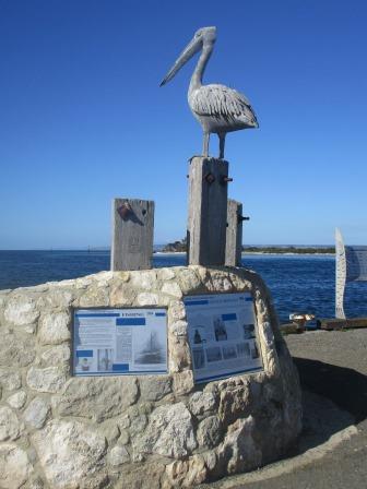
At
the turnoff to our campground was Pelican Pete.

Through
the village of American River and along Flea Castle Road – wonder how it got
that name - out to the northern side to Red Banks. Farmer is losing his land.

Walked
out to the edge of the cliff for a fantastic view. Left to Western Cove .


Zoomed
in on the oyster farm in the Cove.

Right
towards Point Morrison.


Across
Nepean Bay to Kingscote.


Don’t
do it Steve!!

Rick
stirred up the ants nest. Nasty bitey ones too.

I
walked out onto the point with Steve – no insurance policies now so no point
pushing me off!!


Steve
had found a path down to the beach.


Beautiful
colours.


Back
up again along the lovely tree lined road.


Stopped for a sheep’s view over the bay.


Stopped for a sheep’s view over the bay.

Turned
off towards Point Morrison – this is probably what the scrub looked like
originally.

Unfortunately
we came to another private property to couldn’t get to the point. Looking
across to mainland on left and Kangaroo Head on the right.


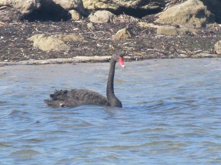
Back
to camp - tide’s in. The swans are out and about.

Headed
down to the jetty to try our luck. The sun is out but the wind feels like it is
straight from Antarctica.

Strawbridge
Point.


History
trail information.


I
heard a noise below me and there was a seal rolling around. I grabbed the
camera and followed him down to the other end of the jetty. Got him head down,
flipper up!!

Then
over the shallows came a fin – the music played the Jaws theme – then up comes
a dolphin – all good!


Went
back to trying to catch something then Mr Seal came back – gave up fishing and
watched him scratch his back. No wonder we aren’t getting any fish.


Cooked
dinner early then went back out to Red Banks for the sunset. Rang Tracy and
Grant for a chat as the sun set at 7.30pm. Beautiful.


As
we got ready to leave we saw the lighthouse at North Cape blink.
No comments:
Post a Comment