Clear
sky and cold morning 8.5 degrees at 8am. Malcolm was up early and it was only 4
degrees!! Life of a farmer!!
Beautiful
day and no wind so just need t-shirt and jumper. Packed up then had a cuppa
with everyone before we headed off. Will call back in on our way back towards
the boat.
Headed
back to Launceston and turned off to St Leonards then through more farming area
of White Hills, a big winery here too. Old building in the front looks like it
was about to fall down.
Followed
the North Esk River for a while. Part of
the Ben Lomond National Park mountains. Can’t see any snow today though the ice
signs have been put up.
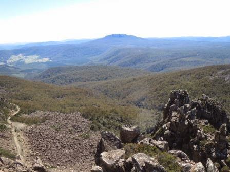
Mount
Barrow and its towers that we saw through the clouds when we were up there.
Turned
off the bitumen road to head up to the top of Ben Lomond NP. We are at 380m elevation
now.
Into
second gear and climbed continually to 760m through stringy bark forest – oops
should have left the van at the bottom or back in Launceston!!! The little
radiator is doing well as the air is still quite cool. Flattened out for a bit
then in thru the National Park entrance (880m). One kilometre on we stopped at
the entrance to the picnic/camp area (1000m). I walked in the narrow road to
check out if there was enough room to turn around. All good so we went in and
parked. There was even a nice flushing toilet. It was a good spot so thought it
deserved a photo of our van even though we weren’t staying the night.
Climbed
up the rise beside the camp to look down on the van then across to the valley
below of Upper Blessington.
Info
board about the forest and the village below us. It is a lovely day that we
only have a t-shirt and jumper on, which is amazing since we are climbing in
altitude.
Heading
up the road – great view of the dolerite cliffs.
Turned
off to head up Jacob’s Ladder to the Alpine Village on the plateau. You can
just make out the road zig sagging its way up the rocky face.
There
is a lookout at the top.
Great
views as we climb up. Each corner has a name, Strickland then Black, Hanging,
Waterfall, Watchtower then finally Gateway.
Finally
at the top with the snow markers. Parked and walked out onto the Watchtower
Lookout (1400m).
An
info board.
The
mountains in front of us – what a magnificent view.
Looking
over Jacob’s Ladder – wasn’t as bad as the road up to Mt Barrow though!!
Then
looking out front to Bass Strait (can’t see if because of the low cloud on
horizon).
Around
to the right.
Then
behind us where a stream of water is flowing down the middle to become the
North Esk River.
With
a view like that it makes you so glad to be alive.
Back
in the car and we head around the bend to look up the plateau (the river flowing
down on the left side) with the village in the distant on the right.
Ben
Lomond National Park’s highest point, the summit of Legges Tor (1572m) is the
second highest peak in Tasmania. There is a walk up to it so we will do that
after we check out the village.
Looking
back down the valley to where we were just parked.
At
1450m we reach the village. Quite a lot of buildings and a lot of ski lifts
too.
There
are poles showing the direction of the Cross Country Ski Circuit, one via
Surprise Valley 2.2km and the other via Little Hell 5km – the second one
doesn’t sound too inviting. So hard to imagine it all covered in snow.
Checked
out the info board showing all the lifts and accommodation huts.
This
one looks nice.
Others
look plain and weathered.
Some
of the chairlifts.
Went
into the Ben Lomond Alpine Hotel. The lady said they had snow last week – what
a shame we missed it.
A
couple of photos by the door show this area under snow. Taken from above the
hotel (our car is parked where the sign is).
Looks
so different now with the alpine shrubs making it hard to walk through.
The
front part of the building is the National Parks shelter hut. It has a creek
going under it.
Loved
the Ford.
Headed
back to do the walk to the summit. There are lodges up there too but no roads
to them!! The track was rocks which a stream was running down too.
We
just kept following the poles.
The
water was so clear.
Our
truck is looking very small.
Looking
down the valley again.
Still
climbing.
At
last we find some huts.
And
a wallaby.
Up
above the other mountains now (1550m).
The
Summit Lodge doesn’t look very inviting. Lots of rubbish everywhere but I
suppose they have to carry everything in as there is no road.
A
memorial cairn outside for the President of the Alpine Club, founded in 1930.
Lots
of bunk beds though.
Following
the poles further up – the huts disappear.
Zoomed
in on Mt Barrow – that’s the tower we saw when the clouds lifted when we were
up there.
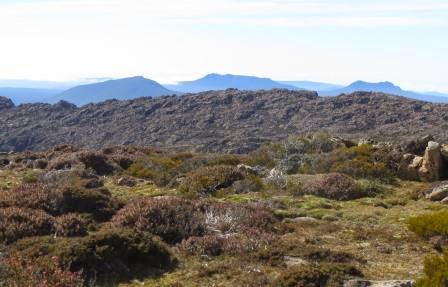
On
the other side from the huts is a basin with the Western Tiers in the distance.
Now
for the climb over the big rocks. A wallaby was leading the way.
Found
the top of one chairlift.
The
rockpile on the summit.
Complete
with balancing rock.
Survey
marker so we have the correct spot as there are no signs.
Steve
adds another rock to the pile.
Our
selfie.
There
are two fires burning now making the horizon hazy – the National Parks do their
burn offs this time of the year. It is lovely temperature up here – not cold at
all.
I
took a video turning around on the spot, then took photos of the view.
Steve
went to the edge for a look back down to our truck. That’s the other hut we
could see from the road.
Found
another hut nestled into the rocks.
Checked
out the chairlift – lots of cables laying on the ground – not looking too
healthy either.
Looking
back over the Village. I don’t think I could ski on it now I know what is
underneath. There would have to be a deep covering of snow!!
Then
around to the right over the chairlifts. We could make out the rest of the
Cross Country circuit too.
Back
over the village I zoomed in on the water that forms the source of the North
Esk River.
Back
down again.
Back
in the truck and heading down Jacob’s Ladder. The fires burning in the
distance.
So
glad we had a clear morning. Can’t get enough of these views even with the
smoky haze.
Back
to the van for a cuppa. It is 22 degrees in the van. Chatted with a guy whose
son is kayaking across from Melbourne. They had some rough weather!! And were
delayed by had made it to Flinders Island. He was meeting them at Little
Musselroe Bay on Thursday and wanted advice on some campsites.
Back
on the flat again – looking back to the massif of Ben Lomond.
We
had to go back to Launceston, through town again (but we know a shortcut now
instead of having to go around the Mall) and then up along the Tamar River and
turn off towards Lilydale.
It
was nearly 5pm so we pulled off to the side to see if there was enough room for
us as it is a carpark arrangement. I waited in the truck – the Alpacas were
used to cars.
Some
had been shorn. Poor things will be cold for winter!!
One
whiz bang was turned sidewards so was taking up all the area we shared last
time with another car. Found space on the other side and backed in. I went over
the picnic hut to chat with a couple from Qld. I thought were from the bus –
but they were in the whiz bang, lucky I didn’t comment on their parking!! Next
to us was another whiz bang with a young Irish couple having a drink. We joined
them – Tracy & Andy from Dublin but they are now living in Melbourne. They
are doing Hollybank tomorrow at 10am. I will try in the morning to see if I can
get a booking.
Lovely
evening.


.JPG)
.JPG)


.JPG)
.JPG)
.JPG)
.JPG)
.JPG)
.JPG)


.JPG)
.JPG)
.JPG)
.JPG)
.JPG)

.JPG)
.JPG)
.JPG)
.JPG)
.JPG)
.JPG)


.JPG)


.JPG)
.JPG)


.JPG)
.JPG)


.JPG)


.JPG)
.JPG)
.JPG)


.JPG)
.JPG)


.JPG)
.JPG)


.JPG)
.JPG)

.JPG)
.JPG)
.JPG)
.JPG)
.JPG)
.JPG)
.JPG)
.JPG)
.JPG)
.JPG)
.JPG)
.JPG)
.JPG)
.JPG)
.JPG)
.JPG)

.JPG)
.JPG)
.JPG)
.JPG)
.JPG)
.JPG)
.JPG)
.JPG)
.JPG)
.JPG)
.JPG)
.JPG)
.JPG)
.JPG)
.JPG)
.JPG)
.JPG)
.JPG)
.JPG)
.JPG)
.JPG)
.JPG)
No comments:
Post a Comment