Warmer
8 degree start at 7am. On the road at 8 so we can get up the range before too
many people get on the road. Had a lot of tourists through yesterday – going to
the winery and the historic Tea House at Megalong. Made it up ok – only met 3
little cars. Hey Wendy – the aerial doesn’t bother me at all but features in a
lot of photos!!!
.JPG)
.JPG)
On
the main road through Mount Victoria and down the range into Hartley Valley
towards Lithgow. 1100m down to 830m – steep descent. Then down again to 730m
(my GPS is good) then another steep climb up to 920m. Poor old truck working
hard. Past by Lithgow outer suburbs – lots of houses going up.
Another
lovely day with puffy clouds. Passed a
power station that wasn’t working but further on another one was pumping away
(Mt Piper Power Station). Big coal mine up the road – you can see where they
have mined the hills around here. It is amazing what photos I can take while we
are zooming along!!
.JPG)
.JPG)
Saw
our first wombat but unfortunately he was dead on side of road near Ben Bullen.
Lots of dead kangaroos in the middle of the road too. Drier open farm land.
Passed a sign stating Capertee Valley is the widest canyon in the World. Missed
the lookout as it was on the right on a corner with no advance signage!!
Stopped at Capertee to check out their signage at the rest stop. The Capertee
Valley is wider (by 1km), but not deeper than the Grand Canyon in USA and is
the world’s largest enclosed valley. The Capertee Valley is also 10 times older
than the Grand Canyon, having been carved, by rivers and streams, over a period
of 90 million years. The Capertee River runs through the heart of Capertee
Valley, turning into the Colo River when it meets Wolgan River in the centre of
Wollemi National Park. Near the southern edge of the 30km wide valley is
Pantoneys Crown, rising dramatically from the valley floor to a height of
1000m. It is also an important area for coal and oil shale.
.JPG)
.JPG)
.JPG)
The
wattles are in bloom which is nice against the plain coloured trees and open
green pastures. Looks a bit like the tablelands.

Drove
to Ilford but not much there so headed to Sofala. Missed taking photos of great letterboxes
though – a train, chopper push bike and a big tyre with the letterbox in the
middle.
We
came down a steep descent and could see campers by the river but it was a sharp
turn in through a guard rail on a corner, lucky that isn’t our camp area.
Across the Turon River and stopped at the info display and footbridge just
beside the 4 ways (to Bathurst via Wattle Flat, to Hill End, into Sofala
village or back the way we came from Ilford). The info display was great with
lots to read about the history of the footbridge and Sofala as the oldest
surviving gold town, established in 1851. Population in 1888 was 25000, in 1988
it was 72. This monument was erected to celebrate the 150th
Anniversary of the proclamation of the town.
There is thimble gear, buckets & chains that were once part of the
Turon River Gold Dredging Company’s dredge. Operations commenced in June 1899.
Two dredges were used and they recovered 29,319 ounces of gold. The dredges worked
till 1914. Plus a 5 head stamper.

The
Sofala Footbridge was built sometime before 1860 in England and transported
here. It was the first bridge across the Turon. As the police station was on
one side of the river and the town, pubs and jail were on the other, it was
hard when the river was swollen to quell the rowdiness that was typical of a
gold rush town. In 1930 a new all weather bridge was built. The old bridge was
restored in 1974 and a picnic area was created too. Unfortunately in 1986 a
huge flood washed it downstream. Sometime later a local found parts of the
bridge and pulled it out with his dozer. Joyce Pearce formed a committee and
worked tirelessly to have the bridge repaired and put on display again. It is
was too difficult to erect it as a bridge again so they put it at the entrance
to Sofala and it has become a tourist attraction again.

We
walked into the main little street of Sofala to check it out. Found the
original site of the footbridge.

Quaint
old buildings and murals. Found out “Oldfellows” was a Lodge group of men, like
Masonic. They have ritual handshakes etc and all that stuff. Now Gran &
Grump live there.
.JPG)
.JPG)

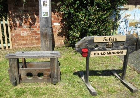
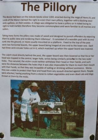
The
child minding devices were interesting – The Stock & Pillary.

This
old house is for sale – it is in need of a lot of loving care and attention.
Would be interesting to find out how much!! It was built in 1851 and was
originally the “Gas Hotel”. The block on the west side is included in the sale
(809m2). The sign said it comes with the original old tin bath and some of the
window glass would be the oldest in Australia.
.JPG)
Love
the front porch flooring.

Not
sure if these are original or they are done up to re-enact the era of time.

They
are renovating some more old homes – major job!! I hope they keep going with
developing the history/tourism of this little village as a lot of people
stopped for a look but there was only one café open and they weren’t the
friendliest. The old Goal is a museum, coffee shop, accommodation, open 7 days except for now as it says "closed".

Found
a black faced sheep – have seen so many in the paddocks. This chap was lonely
but I think he wanted food more as he was checking out my camera for a nibble.
.JPG)
Thick
wool.
.JPG)
Maybe
we should market this new invention – bicycle mower. I think the sheep is doing
a better job.

Did
a two street blocky on foot so back to the car as we found the road we need to
find our campsite down by the river at Greens Point. Pulled up in the big open
area near the toilets and followed the tracks down by the river looking for a
campsite. Only a few other campers here. Liked an area on the other side and
there was a shallow area to cross over. Back to the van but first we needed to
top up the front water tanks. We did the slow fill from the water tank (which
were nearly full), made lunch while we waited.

Down
the track and across the shallow crossing of the Turon River to our campsite.


Nice
clear, very cold water, wide with lots of frogs croaking. The River is lined
with oaks (casuarinas) all the way.
Set
up camp looking up the hill side as the creek view was blocked by the big pines
and lots of fallen trees. Collected lots of firewood.

The
sun was out and it got hot so it was nice to change into shorts and singlet for
a while – the breeze was still cool if you weren’t in the sun.
Updated
my map on where we have travelled. I have been marking off the roads in the
Camps 7 maps which has more detail.

Back
into town to get some milk and find out any info on detecting. The café was
busy but not too friendly with lots of signs about not taking photos of their
maps etc. A couple pulled up in the old 1934 Plymouth.

Found
another great mural. Shame about the big air conditioner.

We
went back out of town across the bridge to check out another camp area we saw
as we drove in. Only a small turn in through the guard rails down to the river.
Nice area but no facilities – good swimming area. Back along the Upper Turon
Road to the first camp area – Ration Point. Lots of tracks following along the
river so plenty of areas to camp.

Crossed
the Turon River just past our camping area and followed the road for a while as
it meandered up the hills and then following the river again. Turned round when
it crossed the river again. I looked on the GPS and it keeps going to either
Capertee or turns off and it goes to Wattle Flat.
Back
to Greens Point and spoke to a guy wandering off with his detector. He showed
us his map of the area and I took a photo so Steve can work out where to
detect.
.JPG)
.JPG)
Back
to camp for a cuppa and Steve headed off up the hill in search of gold – no
gold but lots of rubbish.
Lovely
fire under the clear night sky – till we got too cold and back into the van.
No comments:
Post a Comment