Up
early with backpack ready to hike all over Wilson’s Promontory. Past the Park’s
entrance we spotted a common wombat wandering up the road. Ran back and got a
couple of photos before he clambered up the side of the bank and into the bush.
.JPG)
Crossed
over the Darby River bridge. Quite brown with tea tree colour but clear
otherwise.
.JPG)
.JPG)
Big
sand dunes around here.

On
the climb up over Darby Saddle we look back over Shallow Inlet where we are
staying with Foster Ranges in the background (all dairy farms around there).


Down
to the sea and looking over Shelback Island.

Mt
Oberon comes into view. It reaches 585m above sea level.

Stopped
at Glennie Lookout. Great views, shame it is cloudy but that’s better than
raining as they predict later today. We can come back again when the sun is
out.
.JPG)
.JPG)
.JPG)
.JPG)
This
might be our shortest walk!!

Turned
off to Tidal River Camp area and the National Parks Information Centre. Found
out that it is a 17km hike down to the southern point of Australia. There is
still a road down to Roaring Meg which is called the Telegraph Track. We think
Erica & Terry would have been able to drive that far when they were here
many years ago. ParksVic seem to only look after the young and fit as
everything has a hike from a carpark. Even the beach from the campground is
550m walk.There is a hut for overnight at Roaring Meg so you can do it in two
days or pay $300 for an exclusive room in the Lighthouse though that is another
few km walk!!! I said “how do the parks people get down there to clean it” and
the Parks lady said “they drive”. I let them know what I thought!! On the
weekends they have a shuttle to take people up to the small carpark at the
Telegraph Saddle, then you walk up the formed road to the Telephone towers etc,
uphill for 3.4km for an hour. Then you climb up the granite rock to the top.
Don’t know what they provide for anyone handicapped or aged with walking
problems!! Why couldn’t they do a shuttle down to Roaring Meg and then you have
a 3.7km 1hr walk to the most southern point of Australia – had my whinge then
we headed off to climb to the highest point on the southern point of Australia
so that might have to do us.
Drove
up the eastern side of Mt Oberon to Telegraph Saddle. Noticed a big landslide.

Looking
back over the road we came in on.
.JPG)
Made
a cuppa and wandered over to the lookout.
Zoomed in over Waratah Bay and saw Cape Liptrap in the distance. Notices
about the damage to the Telegraph Track after major storms and rainfall in 2011
which caused a lot of landslides.

Took
a selfie with Mt Oberon behind us as our southern most point we could get to. The
clouds are closing in so we decided we would wait to do the hike when the sky
was clearer.
.JPG)
Back
to Tidal River camp area and we followed the trail over the bridge to Pillar
Point (2km walk).
.JPG)
.JPG)
.JPG)
.JPG)
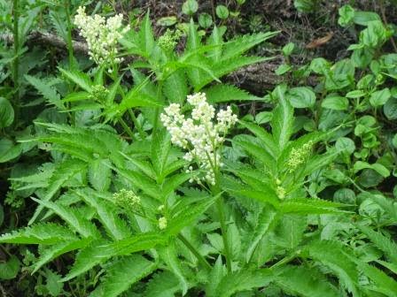
Found
those “marijuana” plants again with flowers.
Good
views over the river as it heads out to sea.

Mr
Lizard to lazy to move.

Big
granite boulders just waiting to fall into the river.

A
Superb Blue Wren flitting around.

Looking
back to the bridge. The water is tea tree brown till it meets the sea water
coming up on the tide then the river is crystal clear.

Then
out to sea.

Further
round and we look over Norman Beach.

Looking
back over the camp area which is quite huge.

Across
Norman Beach and Bay to Mt Oberon.

A
few seals frolicking in the waves – oh hold on, they are surfers!!!

Onto
the ridge and we look down over Squeaky Beach. Gets its name from the sound it
makes when you walk on the rounded quartz sand.

Out
onto a granite boulder on Pillar Point with 360 degree views. Squeaky Beach/Bay
and Norman Beach/Bay with Mt Oberon behind. Took a video.
.JPG)
.JPG)

Standing
on Pillar Point. Chatted with a couple from Sydney (who took the photo of us) who are planning to retire
next year.

Jonathon Livingston Seagull wanted our attention.

The
whole of Squeaky Beach bay.

There
is a walk from there across to the two beaches, Picnic and Whisky on the other
side.

Took
photos of the changing vegetation as we walk back to Tidal River.
.JPG)
.JPG)
.JPG)
.JPG)
Lots
of grass trees and notices about stopping a disease that was making them die.

Another
pretty flower.

Back
at the Info Centre – huge whale bone but no information about it.

Drove
to Norman’s Lookout to make some lunch and enjoy the view. Round the corner
into Picnic Beach carpark, then the hike. Looked down over Picnic Beach as we
walked along the saddle of the point going out between Picnic and Whisky
Beachs.


The
sea is so calm and it has warmed up a lot (something to do with the weather
closing in) – no need for a jumper today. Would be a great day to go to
Tassie!!

Even Steve is pointing out the flowers now. Cute
little bell flowers along the path.

They
put these timber grid things in to help with erosion but it makes a bit step
going back up.

Decided
the weather looked good enough for the hike up the mountain so skipped the hike
down to the beaches.
Back
up to Telegraph Saddle and loaded Steve with the backpack and off we trudged to
Mt Oberon Summit. Checked the time, 1.30pm so we can see how long it takes us
as they say 3.4km 1hour. The nice wide well maintained road was good to walk on
even if it just keeps going up – the photo doesn’t do just to the incline. Wasn’t
unbearable but it kept chatting to a minimum.

Lucky
I can click as I walk though after a while I decided I would take photos on the
way down instead. Lots of lovely flowers as we walked up the sheltered eastern
side.

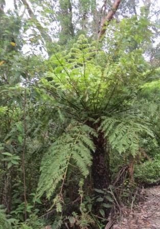
Tree
ferns along the way and it looked quite sub-tropical as we worked our way up.
.JPG)
.JPG)
Decided
this was a wombat slippery slide.

More
pretty flowers.

At
last the Telephone towers, nearly there.
.JPG)
.JPG)
Now
the climb up the granite boulders to the summit.
.JPG)
We
had forgotten how much we hate stairs!!

The
Telegraph Track leading south to Roaring Meg and South Point. Last view of the east side before we come out and look over the west.

Nearly
there. Lower scrub up here and you can hear the wind roaring.

At
last we reached the Summit. Took us 55 mins.

The
wind is blowing about 40 knots which made my knees wobble so I was happy to sit
down and chew on a muesli bar. Steve wandered near the edge but the wind was
blowing him back to me so he couldn’t fall off. Steve stood behind me for
support as I took some photos and videos. Looking down on Tidal River and the
Campground area. You can see the bridge and the walk we did to Pillar Point.

Norman
Beach and Bay out to Norman Island.

Round
to the north.

Looking
south to the southern point of mainland Australia.

Zoomed
in on an island off the south point with a ship going past.

Time
for some pose shots.
.JPG)
.JPG)
I
am sitting next to the Geodetic Survey Victoria Triangulation Station, Mt
Oberon.

More
photos from Pillar Point back to Tidal River and campground.
.JPG)
.JPG)

The
boulder we stood on at Pillar Point.

The
young ones head off to climb another pile of rocks – now I know my age!!

Great
phone reception here so took a photo of the view and sent off a few texts.
“This is the view from Mt Oberon, howling wind etc”. Jon sent one back with a
photo of a kitchen he was working at with “This is the view from Lot 570
Hillary Drive North Point, 36 degrees, no wind, very humid” – such a funny
boy!!!
Steve
found another boulder off to the backside out of the wind which gave us more
views over the eastern side from the south to the north.
.JPG)
.JPG)
.JPG)
.JPG)
.JPG)
.JPG)
Zoomed
in to Corner Inlet which is on the eastern side of the peninsula from Shallow
Inlet. Lucky I took my map so we could get out bearings. We can make out Duck
Point then across to the mainland where Port Franklin would be. Wonder how
clearer it would have been on a clear blue day.


Zoomed
in on where I think the southern point would be and I think that is Wattle
Island off the point.

Zoomed
in to the north on the long sand spit from Sandy Point. Hidden behind the hill
is the mouth of Shallow Inlet. Will have to see how far it is to walk down to
the mouth from where we are camped. The National Park goes up and just past the
mouth too.

Onto
another boulder on the windy side again for more photos – got the wobbly knees
again. I need a railing then I am all good. Different angle down the coast –
that was the island I took before with the boat.

.JPG)
Raindrops
started to fall so we headed down the stairs and back down the mountain. These
flowers gave off a lovely honey smell.

Back
down the boulder walk.

Squeeze
through the boulders.

A
Banksia, I think. Much nicer walking down.

Cute
little echidna wandering up the road (half the size of the others we have seen
and only little spines). Wasn’t worried about us at all. Sticking his nose in
the bank chasing food.

Back
to the truck and down to the campground for a well earned cuppa. Took us 45mins
to descend. Glad we did the hike and maybe next year we will do it again on a
sunny day.

.JPG)
The
trees have such unusual trunks and look all twisted.
.JPG)
Enjoying
my biscuit when this friendly chap flew in for a bit. He is my “ding ding”
singer – the Eastern Rosella. Had found some info on birds at Arthur’s seat
which I photographed and it has come in handy. His buddy arrived and they got
really cosy.
.JPG)
.JPG)
Steve
had a lovely time taking some photos as they nibbled away on their biscuits.
.JPG)
Then a Crimson Rosella arrived and promptly landed on Steve’s shoulder. Then I had fun taking photos of him with his birds. Got a good one for Facebook.
.JPG)
.JPG)
.JPG)
.JPG)
One
flew up to the rafters and next minute there was a squawk and the little birds
were attacking him. They had a nest above us. I think they were Eastern Yellow
Robins.
.JPG)
.JPG)
There
was a War Memorial beside us.

Also
one for Commandos as Wilson’s Promontory was the training ground for Australian
and New Zealand elite commando force during the darkest days of World War 2.
Very interesting.
.JPG)
.JPG)
.JPG)
.JPG)
Headed
back home but stopped at Darby Beach. Only a 1.1km walk!!
Trudged
along the track beside the Darby River – lots of frogs croaking and plenty of
wombat holes and tunnels through the scrub. Up the sand dune and eventually
onto the beach. One lone surfer here.
.JPG)
.JPG)
.JPG)
Thought
this rock looked like a turtle about to bite something.

It
has now got quite cold with the wind and little drizzle. Took a few quick
photos then back up the sand dune and along the track.
.JPG)
.JPG)
.JPG)
Looking
back over Darby River to the sand dune we climbed over.

Then
up to the bridge over the Darby River.

Headed
back home – still a few walks I would like to do so we will be back. Just read
in the brochure that it is an offence to feed the animals – oops, no one told
the bird that, he just helped himself.
Warmer
night with the little pitter patter of rain on the roof.
No comments:
Post a Comment