Overcast
morning (16 degrees). Packed lunch etc in the truck and headed off to explore
Cradle Mountain area. Back down across Forth River again – very narrow valleys
between high mountains make great spots for the dams for the Hydro
Electricity. There are two more power
stations around here, Cethana (turn off up the other side before the bridge)
and Willmot (further up the range).
Lots
of dead possums on the road. Poor truckies have to use this narrow road too –
hard slow pull for them. No pull off areas or overtaking lanes and just wide
enough to have the wheel on the road!!
Passed
some emus and a nice letterbox then the Post Office tree so will have to stop on
the way back for a photo. Through Daisy Dell area where there is a sign Daisy
Dell Oval – more things to find out about. Across Weaning Paddock Creek – love
the names. Across Middlesex Plains (obviously the people were from England!!)
.JPG)
Turned
at Learys Corner and stopped at the information board. Lots of dead trees –
looks so desolate. Over the Iris River which looks like a little creek. Stopped
at the National Parks Centre. Great article on why the trees are dead – that
answered that question.

Details
of short, half day and full day walks. We will start with short!! They only
allow so many cars up to Dove Lake carpark so as it is early we will try,
otherwise you catch a shuttle bus. Nice drive up overlooking Cradle Valley.
.JPG)
Narrow
roads though. First glimpse of Cradle Mountain.
.JPG)
.JPG)
Drove
along the valley to Dove Lake Carpark, there is a boardwalk that takes you the
9km up to the lake too (960m altitude). Wow,
Dove Lake and Cradle Mountain does look majestic.
.JPG)
Decided
to have a cuppa first but oops forgot to put the gas canisters back in the
truck after packing them away for the trip across to Tassie. So water and
biscuit and off we went. Listened to a chap discuss with his walkers which way
to go. Some doing the Dove Lake Circuit which we were going to do. Others are
going to Mount Marion – there is a shorter but steeper walk or a longer one
around the back and up. Might think about that. Lots of other walks from here
too so will get one done then think about what else we want to do.
Photo
of Glacier Rock and Mount Marion from carpark.


Easy
walking through the low shrub area – Mr Wallaby wasn’t worried about us
trudging past.

Climbed
onto Glacier Rock – heard it called Chicken Rock and on another map Suicide Rock.
Great view. Light breeze but very comfortable
for walking. The sun is peaking out and is quite hot when you are in it. They
are right about how easy it is to burn in Tasmanian sunshine.
Mt Marion
.JPG)


The
put a gate of the walk to Glacier Rock as there is nothing to stop you from
falling off the rock.

Making
good use of the bum bag Steve got for Christmas.

Followed
the boardwalk and paths down to the little beaches. Water not a cold as Millaa Falls!!
But I don’t think I will have a swim!!


Pretty
good reflection – just a light breeze disturbing surface.

Easy
walking on the boardwalk and its level beside the lake.
.JPG)
.JPG)

Looking
up to Mount Marion which is a hard walk up to but magnificent views I am told.
.JPG)
.JPG)
.JPG)
Lots
of interesting trees and flowers. Took lots of photos but will select only a
few for the Blog!!!

.JPG)
.JPG)
Looking
back to the truck from nearly the other side of the lake.
.JPG)
Great
view looking straight up to Cradle Mountain. Another chap said that it was
originally called Saddle Mountain. I
agree it looks more like a saddle and the other one we were walking around the
base of looks more like a cradle.


Honeymoon
Islands – did they swim out!!

We
could hear a waterfall so zoomed in below the dip on the right of Cradle
Mountain.
.JPG)
Zoomed
in closer on the two sides of Cradle Mountain.
.JPG)
.JPG)
Pretty
flowers and interesting plants.

.JPG)


Cradle
again and across to the other side where we walked under.


The
other side under Mount Marion has some old boardwalks through higher trees.
.JPG)
.JPG)
.JPG)
Another
look back to Cradle Moutain.
.JPG)
This
side isn’t flat so up the stairs we go.

Through
the Ballroom Forest, considered the walk to Lake Wilks but it looked like too
many stairs.
.JPG)
.JPG)
Stopping
at a beach area and looking back to Cradle Mountain I asked someone where Lake
Wilks was and they said over the ridge (I thought it was the dip just over the
ridge).

Glad
we didn’t go. The mobile rang – it was our accountant with a couple of
questions!!! Looking up at another waterfall.
.JPG)
Mr
Currawong scoring a few nibbles.

Climbed
up the hill, a rocky surface track here. Rest area provided so stopped for a
few more photos.

.JPG)
.JPG)

Lots
of loose big rocks beside and on the path here. This side is definitely harder
work than the other – maybe they need a bit more info on their walk signs. Poor
girl with a school group is really struggling.

Getting
closer – over the ridge with the point that goes out into the lake. Looking
back to the carpark. Truck is still there – looking forward to a cuppa now that
Steve got a gas canister off another camper.
.JPG)
Pink
mountain-berry, I had a little Christmas decoration that was exactly like this.
.JPG)
Down
the ridge on the rocky walk.
.JPG)
Nice
view over the lake.

Into
more open flat area – more great photos.
.JPG)
.JPG)
Passed
the boat house. It would have been lovely back in the day to stay here and boat
etc before the National Parks took over.
.JPG)
Tasmania Snow Gum.
.JPG)
Stopped
at the turn off to Lake Lilla, looks nice.
.JPG)
Good
map showing the elevation of the lakes.

There
was a very hungry Echidna having a feed. He wasn’t worried about us at all,
just carried on having a feast. Took a video of him.
.JPG)
Looking
back over the Boat Hut, Dove Lake and to Cradle Mountain – lovely.

Kept
going back to the truck for lunch.
.JPG)
Steve
had asked a man if he had a butane canister we could buy, which he did but
didn’t want any money for it so we enjoyed a lovely cuppa with lunch sitting at
the Sign In Hut looking at Cradle Mountain. The clouds have started to move in
more and are a lot darker.
Talked
to some people who just came down from Hanson’s Peak (on the ridge I said
looked more like a cradle).They said the views are good but it is a rocky climb
with chain to hang onto – decided we are not that adventurous. They have done
the Overland Hike a few times and are disgusted with some of the people that
come up from the other side with the grog etc and leave a mess. It is sad these
idiots are ruining things for everyone and they mustn’t really being doing it
for the enjoyment, just to tick it off as “done”. He said the Overland Hike
costs $200 as well as the NP pass.
We
decided the walk back to Lake Lilla and Wombat Pool would do us, then a few
shorter walks as we headed back out of the Park.
Button
grass.
.JPG)
Only
a little way down the track we overlooked the Lake.
.JPG)
Then
we went down the hill edge to the Lake, which means we will be climbing back
up!!
.JPG)
The lake water goes into Lilla River which works its way down the Valley. The water from Dove Lake goes down Dove River on the other side of the ridge to meet Lilla River at the wide part of the valley near Ronny Creek car park. Trying to follow where the rivers go is interesting. Then the water goes into the Iris River which flows into Lake Gairdner (where we were going to camp) – another dam there. That flows into the Willmot River and meets the sea at Turners Beach.
The lake water goes into Lilla River which works its way down the Valley. The water from Dove Lake goes down Dove River on the other side of the ridge to meet Lilla River at the wide part of the valley near Ronny Creek car park. Trying to follow where the rivers go is interesting. Then the water goes into the Iris River which flows into Lake Gairdner (where we were going to camp) – another dam there. That flows into the Willmot River and meets the sea at Turners Beach.

The
river disappears into the lowlands.

We
could do the Overland Track from here – only 5 days!! The sign said 15mins to
Wombat Pool so off we went.
15
minutes uphill!!! More stairs – we are not complaining but maybe a bit more info
on the signs!! There was a family ahead of us so we had to keep up with the
kids!!
Top
photos looking over Lake Lilla to Dove Lake and part of Cradle Mountain. Notice
the difference in the water height.
.JPG)
.JPG)
Lucky
I had to stop a lot to take photos as we climbed up!!
Over
the hill and down again to a lovely little pool but that wasn’t Wombat Pool so
on we went.
Finally overlooking Wombat Pool.

Looking
over Wombat Pool to another track leading up the ridge to get to Marion’s
Lookout.


Down
the boardwalk to the seating area – someone said we might see a platypus. Must
be wombats here as there is lots of poo everywhere.

Looking
down the valley where the river will go.

Zoomed
in on hikers on the ridge.
.JPG)
Great
view over the pool which is now “poo” to Cradle Mountain left peak.

Back
down the steps to Lake Lilla.
.JPG)
This
sign on the exit side of the Dove Lake Circuit as they make you go clockwise
around the lake. Would be better at the start!!
Back
to the truck for a cuppa, getting a bit cooler now as the clouds close in, so
on with the jumper.
Last
shot of the Mountain and closer into the rocky outcrop.
.JPG)
Top
end of Cradle Valley with the boardwalk going down beside Dove River.
.JPG)
Stopped
at Waldheim the home built by Gustav Weindorfer who discovered Cradle Mountain.
He believed this area should be made a National Park when he was sitting on the
summit of the Mountain and declared “this must be a National Park for the
people for all time.” Very interesting. His
chalet that he started building in 1912 from the King Billy Pine in the area
has been rebuilt.
.JPG)
.JPG)
.JPG)
.JPG)
.JPG)
.JPG)
He
started in March 1912, over the years he kept adding more rooms. His wife Kate
was an enthusiastic botanist, unfortunately she died in1916. A recording told
you of his story and there were interesting information boards to read. Gustav
died in 1932 then Lionel Connell took over running the Chalet. He was appointed
the first officially appointed ranger of the Cradle Mountain area. He and his
wife made it a homely place and added more rooms.
Wombats
like it too now that he isn’t putting them in his stew!!
.JPG)
Unfortunately
after the war and over time the building fell into neglect and with the snow
crushing it, it was condemned and demolished in 1976 and this replica was
built.
The bath house. The water was freezing!! Would make a good shack up at Maytown.
.JPG)
The bath house. The water was freezing!! Would make a good shack up at Maytown.
Walked
around the forest – so enchanted. Could imagine living up here in the snow.
Sounds romantic but would have been a hard life but they loved it.
.JPG)
.JPG)
Out
of the walk to the Picnic Hut built by Connell. Looks over Cradle Valley. Going
to the right you can follow the boardwalk around the back to Crater Lake and
the longer but not as steep ascent to Marions Lookout.

.JPG)
.JPG)
Good
information about the creation of Cradle Mountain.
.JPG)
.JPG)
Obviously
they used to have lovely fires but now it is electric heaters!!

Beside
another building was this cairn with direction dial on top, dedicated to Mr Connell.
.JPG)
Gustav is buried here and following Austrian tradition everyone meets there on New Years Day to celebrate his life.
.JPG)
Further
down we stopped at another NP Centre and followed the boardwalk to Pencil Pine
Falls on Pencil Pine Creek.
.JPG)
A
love lock. The only one and it is heart shaped. Cute.

A
few tree info plaques along the way. This one is Myrtle Beech.
.JPG)
.JPG)

Another
cute echidna enjoying a snack.
.JPG)
Across
the road is a little fall then we followed another path called Enchanted Walk upstream of the Pencil
Pine Falls. Sign said we might spot a wombat!!
.JPG)
Lovely
Pencil Pines.
.JPG)
This
bridge has a 4 person load limit!!

Lovely
creek.
.JPG)
.JPG)
Saw
a Scarlett Robin – so cute.
.JPG)
Passed
lots of wombat holes.
.JPG)
As
we came into a clearing there he was - a wombat. He was happily munching on the
grass so we just stood and watched him for a bit – lots or photos and a video.
Looks so much healthier than the one at Wilsons Promontory.
.JPG)
.JPG)
.JPG)
Has
some nasty looking claws so didn’t try to pat him.
.JPG)
The
misty drizzle has started so we skipped the walk to Knyvet Falls.
Headed
for home past the dead trees.

Another
wombat beside the road. Can’t find one then they pop up everywhere. Scared
another one back into the bush as we headed back along the main road.

Stopped
for photo of the Post Office tree. This area (Middlesex and Daisy Dell) was
huge logging area.

Mr
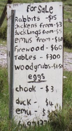
Emu came over for a chat.

This farm sells lots of different things – not sure if that is $60 for an emu alive – or emu meat!!
Passed
the turn off to Lemonthyme Lodge where there is another couple of waterfalls
but a lot longer walk to them so decided we had enough waterfalls to see.
Did
the hard left hand turn on the narrow dirt road down to Lake Gairdner. Wasn’t
that bad – Steve would have come down – the lady just made it sound dangerous
but she didn’t like visitors at all!! The lake is low too. A couple of campers
here but you are miles from the lake.

Iris
River (we crossed it at Cradle Mountain) feeds into the lake.

Zoomed in on Willmot
dam wall at the other end.
.JPG)
Cute
letterbox.

Back
up to Moina and we followed another dirt road to Willmot Dam which we could see
from the Lake Gairdner camp site. Couldn’t get to the dam, just the boat ramp.

Back
onto the steep descent down to Forth River. Steve amazed at 100 speed sign for
the descent. Turned into road to Lake Cethuna Lookout. This is the dam wall we
look at as we cross the Forth River.
.JPG)
.JPG)
Looking
up the hillside is a huge pipeline going straight up. The water from Willmot
Dam (Lake Gairdner) flows down the pipeline and into the power station below
then into Lake Cethuna. Quite a complex system.
.JPG)
.JPG)
Wouldn’t
want the job of checking the pipes – check out the stairs!!
.JPG)
Stopped
at the big sheds of the Hydro Tasmania site which has a huge 9 panel mural
depicting the Hydro system.
.JPG)
.JPG)
.JPG)
Great
information too to explain where all the water goes etc.
.JPG)
.JPG)

Back
to camp, remembered to take a photo of our campsite for the blog.

It
is dark for 6pm as the sky is quite heavy. Some overseas campers (in a very
little car with a tent on the roof) and another Qld couple had a fire going. We
were going to join them after dinner but the rain put a stop to that.
Quiet
night recovering from a big day walking.
No comments:
Post a Comment