7am
it is 10.7 degrees in the van but only 6 degrees outside. Blue sky but some
clouds hanging on the mountain tops.
Headed
off to explore. Stopped at the canal to read the info how the two lakes are
joined and flow to rush through the generators to create power at Gordon and
Serpentine Dams.
.JPG)
.JPG)
Lots
of info I have read said to stop at the Creepy Crawly Trail on the way down to
the other two lakes. Parked across the road and headed in. Someone had left a
walking stick so Steve took it for a test run!! It was only a 20min nature
walk. It was definitely crawly as there were trees everywhere across the
boardwalk and we had to creep along. Other than that it was just a short walk
through the bush and back again. Glad it was only a short one as we have seen
enough moss to last us a lifetime!!
.JPG)
Passed
by Mt Anne (1425m) – there is a walk to that one but it was a long one.

Arrived
at the southern banks of Lake Pedder near Edgar Dam, magnificent views to the
mountains.
.JPG)
.JPG)
The
White Monolith Range in the distance.

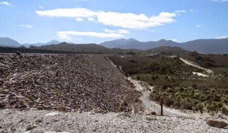
Drove
on to past the Scotts Peak Dam wall and up to the Red Knoll Lookout. Just amazing views over Lake Pedder. Took
panoramic shots around over the lake and a video.
.JPG)
.JPG)

.JPG)
.JPG)
.JPG)
A
direction cairn in the centre of the lookout. So many mountains and ranges to
try and work out which one is which.

It
said Scotts Peak is 4km from our truck.

Looking
over the dam wall to the mountains.

Drove
up to the dam wall and the boat ramp. Info about Lake Pedder’s creation.

Good
ramp and jetty. There was a map showing all the different fishing locations and
you have to fill in a log book as to where you are going etc, like when we are
hiking.

Looking
back at the dam wall.

Another
Engineering plaque.

Looking
along the back of the wall.
Drove
into the Huon Campground. Small camp areas poked into the trees, well away from
the dam. A few groups of backpackers getting ready to do a trek somewhere. You
can go from here down to the south west of Tassie then back around to Cockle
Creek.
As
we were driving out we met a car and boat – roads aren’t wide enough for two
though!! So we backed up.

Drove
into the longterm carpark. Two ladies had just come back from a 8 day trek
around the Arthurs Ranges. Took a photo of the map in the info hut. We are at
Scotts Peak. Good on them though they both look like they haven’t eaten in a
week!!
.JPG)
The
whole south west area trek.
.JPG)
Drove
back out and down another road to the bottom of the dam wall. Steve wanted to
check out the brown bit but it was just netting holding the rocks back.

Steve
got out to check out the tunnel. “Danger from gases – unvented tunnel”. Called
me over to try out the echo. So good I did a video of it!!

The
area is covered in this reddish rock, hence it was Red Knoll.

Old
sign about the dam.

Drove
up another road to another lookout.
Great view again over the Lake.

On
the other side. The water is the top edge of a little dam beside the bigger
Edgar Dam. Arthurs Range is in front and goes left from there.

Edgar
Dam wall (water is part of the little lake on the lower side called Edgar Pond)
and the sign all about it.
.JPG)
.JPG)
.JPG)
Drove
across then to the top of the wall. Edgar Pond to the left and Lake Pedder to the right.
.JPG)
The
Edgar Campground is nearer the dam and more open. A few people are camped
there.
A
guy was hiking back out so stopped to say sorry we can’t give him a lift. He
has just done 12 day hike out to the West Coast to Wreck Bay. There is no trail
out there so he made his own track. He was from Hobart. He had 8 days where he
never saw anyone. Guess he really got to feel what it was like to be an
explorer!!
Stopped
at Condominium Creek where the walk to Mt Anne, Mt Eliza and Judd Lake commences.
The water is so clear here compared to the other tannin stained ones. This
shows the area we are in and how big Lake Pedder and Lake Gordon are.

So
many beehive groups throughout the area. We drove through a mass of them and
unfortunately they splattered all over the windscreen – honey everywhere!!!
Back
up onto the main road heading back to Gordon Dam. We stopped at Boyd’s lookout.
It had a lovely little marked out walkway. Must have been from the early days.
The trees have grown so much I could just peer through and zoom in with the
camera to get a picture. A mountain and white stuff (found out later that this
is the dead trees around Gordon Dam where the water level is low).
.JPG)
.JPG)
At
the Wedge River Picnic Area. Another relic from the past by the looks off the
toilet block.
.JPG)
Someone’s
broom creation left in the picnic hut.

Don’t
know where their clothes are if their suitcases are here by the bin!!

Nice
view though from the picnic shelter.

Wandered
down to the river which isn’t very big. This was is tannin stained.

The
distance markers were LP 40 etc presumably for Lake Pedder but the township on
the map is Strathgordon. As we drive in the first sign is for Lake Pedder then
there is a Strathgordon one too – go figure. Stopped at the Lake Pedder Chalet
which is in the buildings left over from when they build the dam and hydro
generators etc. Inside were displays about the dam etc.
In
1963 the Federal Government provided a grant of $5 million to build a road west
of Maydena into the Gordon River area. Following detailed investigations the
Gordon River Power Development, Stage 1, was approved by State Parliament in
1967 and construction of the scheme began. The development created the largest
water storage in Australia. The two interconnected lakes, Lake Gordon and Lake
Pedder, are nearly eight times larger than Great Lake and three times larger
than Lake Eucembene, the largest lake in the Snowy Mountains scheme. Lake
Pedder was formed by construction three rockfill dams, Serpentine, Scotts Peak
and Edgar. The water from Lake Pedder flows into Lake Gordon through the
McPartian Pass canal. Lake Gordon was created by building a 140 metre high
concrete arch dam across a narrow gorge in the Gordon River. Water from the two
lakes is used in the Gordon Power Station, 183 metres underground. Lake Pedder
provides about 44 % of all the water which passes through the turbines in the
Gordon Power Station. The Gordon Power Station is the largest in Tasmania. The
first two 144 MW turbo-generators came on line in 1977 and 1978. The power
station is automatically controlled from Hobart, 160km away and generates about
13% of the State’s electricity. The third machine was commissioned in 1988.
When the development was designed space was allowed for five machines. The
building of Stage 1 involved the flooding of the original Lake Pedder, a small
lake with a spectacular white beach during the summer months. Conservationists
loudly opposed the development but were unsuccessful in halting the
development. By 1979 the conservation lobby had grown in strength and there was
vigorous opposition to any further developments in the Gordon catchment area.
Stage
2 which was also known as the Gordon-below-Franklin, was presented to
Parliament in 1979. This scheme proposed a second dam on the Gordon River, just
below its junction with the Franklin River, and the single power station would
have re-used the water from the Stage 1 development. In 1982 State Parliament approved
construction of this scheme and work began on building access roads into the
site. In 1983 Federal Parliament passed the World Heritage Properties
Conservation Act which banned construction in the area. The State Government
challenged the validity of the Act before the High Court. It was not successful
and work on the Gordon-below-Franklin ceased.
This
one shows the dam, the generating plant under the ground and a replica of the
Wrest Point Casino as a size comparison. It certainly is deep underground and
huge.

The
sun was coming in the window so it was hard to get some of the photos. This is
the dam wall being constructed.

They
also had a 3D model of the dam area and mountains.
.JPG)
The
dark blue is the size of the original Lake Pedder.
.JPG)
This
shows Gordon Dam (left), Serpentine Dam (right), back to Strathgordon then
Ted’s Beach campground.

Then
down the other end of Lake Pedder to Edgar and Scotts Peak Dams.

Some
interesting reading about the lives of those that started working here in the
beginning and how it progressed on, to grow into a big town.
.JPG)
.JPG)
.JPG)
The
homes were made on site. Great photo showing all the houses. There are only a
handful left here now.

Some
more photos of the dam and power plant construction.

Lovely
area for relaxing and a meal.

Fabulous
view too.

They
have a huge trout over the door.

Walked
around to the front to check out the boat ramp area.

Helipad
and mountains.

The
hills beside look like they have snow but it is the quartzite rocks.

An
info plaque about the weather station there. It is read 9am and 3pm each day.

Love
the little poem.

As
we drove out we stopped to check out the big Huon Pine tree. The ring markings
work out that it is over 2200 years old.
.JPG)
.JPG)
.JPG)
.JPG)
Further
along the road to the dam wall is the Lookout. Great info board showing all the
mountains in the Frankland Ranges on the other side of the Lake.
.JPG)
.JPG)
.JPG)
.JPG)
.JPG)
They are composed of Precambrian quartzite rocks. Its rugged topography is largely due to the former presence of glaciers. Glacial debris from this range dammed the Serpentine River, resulting in the formation of the original Lake Pedder. Precambrian rocks are the oldest rocks in Tasmania. These ancient rocks also underlie the gravel road here.
They are composed of Precambrian quartzite rocks. Its rugged topography is largely due to the former presence of glaciers. Glacial debris from this range dammed the Serpentine River, resulting in the formation of the original Lake Pedder. Precambrian rocks are the oldest rocks in Tasmania. These ancient rocks also underlie the gravel road here.
More
info off the board.
.JPG)
.JPG)
.JPG)
The
original Lake Pedder in 1972.

A
quartzite rock and a close up at the quartz vein.
.JPG)
.JPG)
Stopped
to check out the Gordon Power Station info board. We can’t drive down to the
station.
.JPG)
.JPG)
The
Inlet pipe goes 183 meters underground. 13 percent of Tasmania’s electricity is
generated here.
.JPG)
Notice
all the dead trees on the bank (what I saw from Boyd’s Lookout). They have been
selling off the power to the mainland as it doesn’t incur Carbon Tax so the
water level has been dropping a lot.
.JPG)
.JPG)
Followed
another road which leads down to a boat ramp (unofficial we think as it would
be underwater if the dam is full).
.JPG)
Arrived
at the dam wall and the Sunrise car and trailer were there. Had a quick chat
with the guy as he headed down to the wall area.

Amazing
deep valleys.
.JPG)
.JPG)
Walked
to the end and what a spectacular view.
.JPG)
.JPG)
.JPG)
Looking
over the wall.
.JPG)
.JPG)
Info
board about Gordon Dam.
.JPG)
Check
out the stairs.
.JPG)
First
to get down to the wall then more to get down to the bottom.
.JPG)
The
Sunrise crew were taking some photos using the remote controlled helicopter
thing.
.JPG)
One
chap setting up the satellite dish.

Just magnificent.

Headed
down the stairs – though the little boy needed someone to accompany him!!
.JPG)
He
took his glasses off this time which was better.
.JPG)
The
workers use this cable car – now that would be a great ride!!

Down
we go.
.JPG)
.JPG)
Onto
the wall at last.
.JPG)
Engineering
plaque.

Lucky
we don’t have to go down those ones too!!

.JPG)
Looking
back up.

Then
down to the bottom, 140 meters below.

Looking
down on the valley,

Then
back to the base of the dam wall 140 metres down.

Trent
who is the cameraman from Sunrise was going to have an abseil so we hung around
to watch him descend.
.JPG)
.JPG)
.JPG)
.JPG)
Took a video of him going down the wall.
.JPG)
He looks
so little all the way down there.Took him 3 minutes to get down to the bottom.
.JPG)
.JPG)
Now
the long climb up the ladders.
.JPG)
Such
a lovely view.
.JPG)
This
was the old scenic lookout. Winds its way around the edge of the cliff to the lookout and the flying fox to the other side.
.JPG)
.JPG)
.JPG)
Back
up the top we got a photo beside the Sunrise car and trailer.
.JPG)
Then
we noticed Eddie who does the weather sitting in the van reading her notes so
wandered over to say hello. She introduced herself as Edwina so I said that
Steve’s grandmother and great grandmother were both Edwina too.
There
were in Cairns recently at Cairns Coconut so took a photo of the “I love
Cairns” sticker.
.JPG)
She
is so lovely with such a marvellous smile and happy to pose for a photo.
.JPG)
Trent
made it back up the ladders. It was great to watch – don’t think we will try it
though.

We
made a cuppa and were watching from above. The march flies had moved in – don’t
bite just buzz around your head. Then the swallows arrived and gobbled them up,
yeah!! We
chatted with another couple from Mackay, Ken and Isabel. Ken saw that Eddie was
going to abseil down the dam wall so he thought he would like to try and so
rang Aardvark and booked in to do it the same time. They drove up with their
van and are going to stay here in the car park for the night. We headed back to
our van and decided that we would drive back to the car park too so we can get
up early to watch the recording of the show.

As
the sun goes down, a nice view of the valley.

No comments:
Post a Comment