Wet
cold morning. Glad Mum & Dad were getting a taxi to the airport. They head
home this morning to the heat!! Rang Brian and he said it was going to be 36
degrees. We are expecting a top of 18 degrees!!! Back into the shirts, jumper
and extra jumper as the wind is biting as we packed up. Ducked out to check out
the signs on the causeway over the Pitt Water area as we had missed them each
time we drove in!! It was about the bird reserve on this section which is
Orielton Lagoon.
.JPG)
Back
into Sorell and we stopped to take a photo of this great carving of an existing
dead tree near the playground.
.JPG)
.JPG)
.JPG)
.JPG)
Mr
Seagull decorating the owl.
.JPG)
It
started to rain so didn’t get to check out why the eagle is a different colour.
There is a walk below it so might check that out when we come back.
.JPG)
Had
a cuppa with Rick & Leanne. Penny & Pete had headed out already, we
might catch them Port Arthur way. One good thing going our way is the price of
diesel is dropping, got it for 125.9 at Coles Express.
Turned
onto the Arthur Highway, up and down hills again with open grassy pastures. Lovely
view as we enter Dunalley - a narrow
neck with Marion Bay on our left and Dunalley Bay on the right. Didn’t get the
camera out in time.
Passed
the grassy camping area beside the Dunalley Pub that most people stay at. Will
stop there on the way back to explore this area.
Dropping
down the straight range to Eaglehawk Neck – another narrow strip.

Pirates
Bay on the left – the open seas out there.

Eaglehawk Bay on the right flows out to Norfolk Bay – tide is out and it is very shallow.

The
Blue Seal Café.

The
sun is out now but wind is still cold. Lovely old buildings as we head for
Premaydena.

Drove
through Premaydena, well past a couple of houses and the General Store and
found the Recreational Reserve. It is an oval with a club house for the cricket
club. Parked the van and had some lunch. Premaydena was established as
Impression Bay Probation Station in 1841 and was later a quarantine station.
I
rang the Tuckshop girls for a chat. They had a huge week last week selling
uniforms to the two lots of new students, grade 7s and 8s and as there was a
new shirt design all the school was in to get the new shirt. I decided to leave
at the right time by the sounds of it. They were flat out. Only 3 grades at
school yesterday but all there today so they were kept hopping. Do miss the
girls a lot and loved working there, but this life is great too.
Headed
off to explore the area around the Convict Coal Mines. Lovely view over Norfolk
Bay.

Passed
some interesting houses along the way.
.JPG)
.JPG)
The
Coal Mines Historical Site includes the ruins of a penal station dating 1833 to
1848 and colliery dating 1833 to 1901.The ‘worst of the worst’ Convicts were
sent here to endure the most severe punishment that the system could devise. The mines were developed to limit the
colony’s dependence upon costly imported coal from New South Wales. By the late
1830s the mines produced most of the coal used in Van Diemen’s Land. Stopped at
the first car park and wandered down to the interpretative display of the mine
area etc.

The
chain showed the timeline of the site:
1803
First European settlement in Tasmania at Risdon Cove on the River Derwent.
1830
Establishment of Port Arthur Penal Colony.
1833
Surveyors discover an outcrop of coal at this site.
1834
Government begins coal mining using convict labour from Port Arthur.
1837
Mining expert Dr Lhotsky surveys the mine and reports dangerous faults.
1838
Semaphore in operation on high ground behind the station.
1841
Government introduces the probation system.
1843
New jetty and Commissariat Store built at Plunkett Point.
1845
Peak of population and production. 576 convicts, 27 military personnel, 125
civilians (including 14 women and 90 children) live at the station. 11,375 tons
of coal are produced.
1846
Building of new solitary cells and private apartments to separate the men’s
sleeping quarters.
1848
Government closes the mine because of low quality coal, production inefficiency
and concerns about ‘the moral state of the station’. Mines leased to private
operators, Clark & McShane.
1851
Military guard removed from Coal Mines station.
1870s
onwards – Mining continues under a succession of private leaseholders. The
buildings fall into disrepair.
1880
Jacob Burden runs sheep on the site.
1901
Last recorded leasehold of the mine workings.
1920s
Stone and timber from the ruins are taken to be re-used in apple sheds and
farmhouses.
1938
Four hectares gazetted as Coal Mines Reserve under the Scenery Preservation Act
1915
Mid
1960s Local identity Jack Little worked as curator until mid 1980s.
1971
Over 25 ruins and dozens of mining features are dotted across 214 hectares
which was proclaimed a Coal Mines Historical Site under the National Parks and
Wildlife Act 1970.
On
the wall was information about some of the convicts etc.


Explaining
the coal mining terminology.
.JPG)
.JPG)
Wandered
down to the Convict housing area. Amazing these structures are still here after
all these years.
.JPG)
.JPG)
Headed
down to the jetty, passed the site of the Coxswains Launch Quarters and Clerks Quarters circa 1842.

The
tramway from 1834 coal audit to 1837 jetty.
.JPG)
.JPG)
Surgeons
Quarters circa 1838.

Down
to the beach area – very rocky, where the jetty would have been.
.JPG)
.JPG)
Another
info plaque about Joseph Lacey.

Back
to the quarters area. It is huge area.
.JPG)
.JPG)
Other
buildings’ footings remain on the other side (machinery sheds etc).

Retaining
wall up to the exercise area.

Looking
into the small area which housed 8 cells. The ceiling has fallen in and the
doorways have steel beams now for support.
.JPG)
.JPG)
.JPG)
.JPG)
The
roof over the cells. Amazing how they cut and lifted these slabs of sandstone
into position.

The
two rooms on either side of the cells have caved in. It looks like there may
have been timber floors or supports in here.

The work on the sandstone with the etchings etc is fantastic. Some looks like it was just done.

Looking
over three of the buildings. The building on the left where we went into the
cells was the hospital with three rooms above the solitary cells below. The middle building was the chapel which was
also used as the school room. On the right are three more barrack huts and a
bakery.

This
maps dates back to 1842, some of the buildings are no longer here.

Looking
down into the cells.

Interesting
info about the “moral” of the station.

Different
workmanship on the buildings.
.JPG)
.JPG)
Even
the doorway had decorations – this is the chapel.

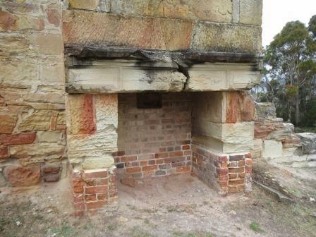
Steve
checked the fireplace, making sure no one stacked their gold up there!!
Over
to the bakery and more barracks (circa 1838).
.JPG)
.JPG)
Looks
like the bakery fireplace has seen better days.

Another
building site and pathway.


These
cottages were built 1850s to 1870s using red brick rather than the sandstone.
.JPG)
.JPG)
Looking
back over all the buildings.

Solitary
punishment cells (circa 1843).
.JPG)
.JPG)

These
were very dark. My camera made them light up.
.JPG)
.JPG)
.JPG)
.JPG)
Walked
back to the car and drove to the next carpark at the Mine site. It is fenced and
of course caved/filled in.
.JPG)
.JPG)
.JPG)
No
information about this old boiler/container.

It
must have been horrific for them going down the shaft, but these were the ‘bad’
convicts and reading the info sounds like a lot of them didn’t improve their
behaviour.


Lots
of small pieces of coal everywhere.

Followed
the path up to the site of the Semaphore Station.
.JPG)
.JPG)
.JPG)
Info
about Captain Booth.

Bigger
pieces of coal here.

Back
to the car and further north to the Lime Bay National Park camping area. Lots
of campers here, maybe Tassie kids don’t go back to school yet.
.JPG)
.JPG)
.JPG)
Slabs of sandstone have fallen off the edge.

Wandered down to the beach.
Wandered down to the beach.

Plenty
of black swans at the end of the beach.

Back
to the other carparks of the Coal Mine area – This one is between the Coal Mine
and Plunkett Point. There is a straight line down from the mine where the
tramway travelled, called the Inclined Plane. It was to be built 740 yards
long, at a gradient of 1 to 11. It takes
advantage of an ingenious system of delivering coal via a double rail from the 1845
shaft (the fourth to be sunk) at the top of the hill to the jetty at Plunkett
Point. The weight of the full cart travelling down the hill pulls the empty one
back up the hill. Of course it was wider and the trees weren’t there!!
.JPG)
.JPG)
.JPG)
John
Smee info.

There
is coal everywhere.

Suppose
to use this to look through to see the sites of the jetties etc.
.JPG)
.JPG)
Further
along the cliff edge towards to quarry is another cottage (circa 1850).
.JPG)
Lovely
view.

Down
to the jetty area.

The
sandstone looks lovely by the water.

The site of the Commissariat Store and jetty 1842-42.
.JPG)
.JPG)
.JPG)
Back
in the truck and on to the next carpark (cheating as these are all walks from
the main site which we were going to do another day but when we headed to Lime
Bay we found that we could just drive to them). This is the air shaft. The
logic behind the air shaft has died with its builders – it is a long way from
the mine site. For its time the Air Shaft was an amazing engineering
achievement.
.JPG)
.JPG)
.JPG)
Heading
back we decided to follow another road to the other side of the peninsula.
Steve spotted a little wombat crossing the road. I got a photo and was going to
get out for another but he ducked into the grass.
.JPG)
He obviously thought that if he can’t see us, we can’t see him. As we waited to see where he would go he greeted us with a ‘deposit’ of both types!! With that, we left him to it.
.JPG)
Drove
to the end of the road till Private Property sign turned us around. Back to Sloping
Main where there is a few houses/weekenders. Some a quite modern and huge.
.JPG)
.JPG)
Noticed
someone has stuffed up with the name – it is supposed to be Sloping not Slopen.
.JPG)
Lovely
long beach. We are looking across the where Hobart airport would be and 7 Mile
Beach.
.JPG)
.JPG)
.JPG)
.JPG)
I
spotted some dolphins slowly travelling along.

Lots
of open grazing land for sheep and cows. A lot of rabbits too.

And
a winery I think.

A
couple more old buildings marked with the convict symbol but no information.
.JPG)
.JPG)
Across
Saltwater River.

Back
to our van in the Reserve. A small tent has been erected on the other side of
the cricket rooms.

Rang
Mum and Dad – they had just got home from the airport at 5.30 (their time). Big
day as they had to change planes at Melbourne, Sydney then Brisbane. They are
glad to be home in the warmth though I said everyone I spoke to was complaining
how terribly hot it was today. Hard to imagine as we sit here in jeans and
jumpers still.
Another
combi van pulled in. A few drops of rain and some wind but otherwise all good.
No comments:
Post a Comment