Another
beautiful day. Cool nights still but we can start out in shorts and t-shirts
now.
Rang
Greg to wish Tracy a happy birthday but the poor girl has had to go to work.
Her third day as Sister Brotherton. Will try her later tonight.
Headed
off on the West Coast Wilderness Way. At 750m elevation took a great photo of
Mount King William 1 (1324m).

Headed
into the Franklin Gordon Wild Rivers National Park, World Heritage Area. Up a range
to 850m to the King William Saddle lookout.


Overlooking
part of the King William Range that divides east and west. Good info board. It
says we are heading into an area that receives 2.5 to 3 metres of rain each
year. Hopefully it won’t come while we are there.

Interesting
info about the creation of this highway.


In
the far distance I could just make out the quartzite peak of Frenchman’s Cap.

Amazing quartzite range.

Down
the range with glimpses of great views between the trees of a deep valley. It
is called Surprise Valley and we then stopped at the lookout (710m). It was a
surprise as it is all overgrown. Stephen climbed up onto the fence to take this
photo.

Dropped
down off the range to 430m into a valley to Franklin River. Stopped at the rest
area. The Franklin River is famous throughout Australia and overseas. About 500
people travel down the river each year in inflatable rafts. It takes up to 3
weeks to complete the 93 kilometre trip, from Collingwood River Bridge to
Butler Island on the Gordon River. Fabulous photos.
.JPG)
.JPG)
Story
of the first canoe trip down the river in 1950s.

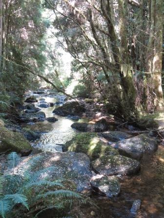
Lovely
quiet little river here.

Getting
closer to Frenchman’s Cap but it is a long walk to get to it still.

Drove
along the mountain edge then into another valley (380m) and across Collingwood
River. More beehives in the natural scrub forests. Up onto the other side
of the valley edge to look over the wide
flat valley (450m). Big mountain ranges to our left called Raglan. Up to 570m
and over Victoria Pass. Passed some cyclists pushing their bikes up the range
and they weren’t young!!! Steep descent and windy, worst than Gillies Range
till we reach the Nelson Valley. Stopped to do the walk into Nelson Falls. Lots
of info as we head in about creating the Lyell Highway. Timber and mineral
extraction continued into the 1970s, however an increasing realisation of the
natural beauty and wilderness quality of this region culminated in the
declaration of the Tasmanian Wilderness World Heritage Area in 1983.
.JPG)
.JPG)
.JPG)
.JPG)
.JPG)
.JPG)
Nelson
Falls is 35m high. Followed the creek along the boardwalk.

Nice
falls but needed more water.

Thought
there was a bridge over the top but it was a couple of fallen trees.

Tall
skinny trees.

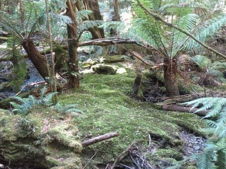
Lovely
mossy area.
As
we crossed back over the little bridge Steve saw a trout. The march flies were
buzzing around so killed a couple and tossed them in and the trout dashed out
and ate them.
Headed
off again – looking to the left to Raglan Range.

On
the other side of the road it was all burnt.

Amazing
mountains in the distance of the West Coast Range. Heading towards Queenstown.

Crossing
over Lake Burbury (250m), another Hydro-electric dam.
.JPG)
.JPG)
Fabulous
views as we run along the edge of the lake. As we pass the valley area it gets
very windy.
.JPG)
.JPG)
Climbing
up then looking back over Lake Burbury. Spectacular.
.JPG)
The
mountains are scarred from all the mining in Queenstown. Heading up the range
to old township called Linda. Not much left.
.JPG)
.JPG)
.JPG)
.JPG)

Further
up is Gormanston (380m). A few houses here.

Up
to the top and pass the turnoff to the Iron Blow lookout (430m). Will check it
out without the van on – looks a narrow road. Down the other side and WOW what
views. I had read in an article about the ‘infamous Gormanston Pass’ and I
figure this is it.
.JPG)
.JPG)
.JPG)
.JPG)
.JPG)
.JPG)
.JPG)
.JPG)
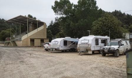
Dropping
down into Queenstown (150m). Stopped at the dump point. While the boys were doing the jobs Leanne and I checked out the
Gravel Oval. Amazing how they played footy on this gravel. Unreal to think that
a football ground is Heritage Listed.
.JPG)
.JPG)
Decided
to drop the vans off there, as it is a free camp area, so we can have a look
around.
Heard
the toot of the train so headed into town to check out the steam train. I got a
photo as it puffed into the station.
.JPG)
.JPG)
Went
into the station as everyone got off the train – Mount Lyell No. 1. It was lovely and shiny.
.JPG)
.JPG)
.JPG)
Climbed
up over the bridge to get a better photo.
.JPG)
There
is a turntable out the front too where the engine will turn around shortly.

Went
outside to watch the train being turned around – by hand too. Got it on video too.
.JPG)
.JPG)
.JPG)
.JPG)
Lots
of interesting posters to read.
.JPG)
.JPG)
.JPG)
.JPG)
.JPG)
.JPG)
Cute
rail bike.

There
was so much information and lots of photos to check out in the Museum.
.JPG)
.JPG)
.JPG)
.JPG)
1912
was the year of a terrible mine disaster. This photo shows a few of the bodies.
.JPG)
Amazing
bridge that the train goes over.

We
decided to go on the train tomorrow to the half way spot at Dubbil Barril so
bought our tickets. This section has the range and therefore the Rack &
Pinion which will be good. Outside Rick found a great poster and laid down to
be run over by it!!

This
shows the angles the train goes up and down.

Across
the road is the Empire Hotel built about 1901.
.JPG)
.JPG)
.JPG)
.JPG)
.JPG)
Steve
found an interesting painting.
.JPG)
Beautiful
staircase is listed with the National Trust. Locally cut Blackwood was sent to
England to be turned and crafted. It was returned to Queenstown in 1904 and
assembled in the foyer and was renovated in 1994. Reminds me of the one in Millaa house. I love the acorns.
.JPG)
.JPG)
.JPG)
Photo
of the first sawmill erected in Queenstown in 1895 by Robert Sticht who came
here to build the smelters to start the mine.

Lovely
old world tiles at the entrance.


Wandered
up the street. Info and pictures in a shelter shed about the mining in the
area.
.JPG)
.JPG)
.JPG)
Grand
old Post Office built in 1902.

Misty
clouds have descended on Queenstown so we won’t be going up to the lookouts
now.
A
lady at the intersection said Mt Owen is under that cloud.

Took
a photo of the cute gecko on the back of a motorhome – should have got one for
our van.

Steve
enjoyed watching the bogans going up and down the street as we wandered back to
our cars.

The
boys wanted to check out this gallery!!

Back
to the vans.
Had
a cuppa then headed back in to check out the museum and other bits I noticed
since we couldn’t go up to the lookouts. Queenstown is set in the Queen River
Valley and was founded in 1883. It was once the richest mining town in the
world. Cute chap in the window.

A
piece of wooden pipe from Lake Margaret pipeline. There is another power
station there that supplied power for the mines etc.

Notice
about the Museum that was once the Imperial Hotel (1898 to 1918). By the turn
of the century there were 14 hotels in town.
.JPG)
.JPG)
Chatted
with the volunteers about places to go and see. Decided to go outside and check
things out first before doing the museum.
This underground Bogger was used at the Henty Mine to dig dirt from the working face and transport it to the crusher, or load it onto a truck to be transported to the surface. It was purchased in 1995 for around $650,000. It was broken into 8 pieces and lowered 500 metres down the Henty Shaft, where it was reassembled. The Bogger worked for 5 years, or 15,000 hours, and moved about 500,000 tonnes of dirt. It was directly responsible for producing 5 tonnes of gold, equal to $100 million.
This underground Bogger was used at the Henty Mine to dig dirt from the working face and transport it to the crusher, or load it onto a truck to be transported to the surface. It was purchased in 1995 for around $650,000. It was broken into 8 pieces and lowered 500 metres down the Henty Shaft, where it was reassembled. The Bogger worked for 5 years, or 15,000 hours, and moved about 500,000 tonnes of dirt. It was directly responsible for producing 5 tonnes of gold, equal to $100 million.

Across
the road was the Miner’s Siding. This Atlas Copco “Jumbo” drill worked
underground at the Mt Lyell copper mine for 20 years plus. On its introduction
the Jumbo was revolutionary in the advancement of productivity underground.
Over five generations of Tasmanians have mined for copper, zinc, tin, iron,
lead, silver and gold.
.JPG)
.JPG)
.JPG)
Nice
shot of Leanne and Rick.

Copper
Ore. Lots of copper castings depicting the growth etc of Queenstown. They were
cast in Queenstown in 1983 by Tasmanian artist, Stephen Walker.
.JPG)
.JPG)
1883 Discoverers of Iron Blow. Lyell Mining Field
origins.

1896 The Abt Railway opens between Queenstown and
Strahan.

1903 Social life of the 20th Century,
Masonic Ball, Queenstown.

1912
October 12th, 42 miners die
in smoke filled workings, North Lyell Mine.

1926
S.L. Nellie rafting Huon pine logs on
the Gordon River.

1932
Motor traffic links West Coast by road
to outside world.
.JPG)
1969
After 73 years of continuous operation
the Queenstown Smelters close.

.JPG)
.JPG)
Photo
of the railway yards where the Miner’s Siding is now.

A
fly wheel that came from the hoist in the main shaft of the Mt Lyell Mine which
was in use at the time of the 1912 disaster.

Drove
over the river to check out Penghana which was built in 1898 for the first mine
manager of the Mt Lyell Mining & Rail Co, Robert Sticht. It is used as a
B&B now and is a National Trust Mansion. Long stairway up to the building
above.
.JPG)
Stopped
to check out the Queen River. Can’t get over the colour. It is from the sulphur
and iron ore leeching out of the ground. Apparently it is ok, just looks
terrible.

Cute
little cottage.

At
the train’s workshop they have this old engine on display showing the inside workings.
.JPG)
Looking
back up to Mt Owen.

Further
down the Queen River is a darker orange.
.JPG)
Dan
could make this letterbox.

Drinkies
in our private pavilion overlooking the gravel oval.

The
council had been there rolling the dirt etc and guys had popped in to take
photos. It is now used for cricket.
.JPG)
.JPG)
Erica
rang for a chat. Still trying to do their trip from the source of the Murray
River to the mouth.
Rang
Valerie. Tried to ring Tracy for her birthday but no answer, must be out having
fun.
No comments:
Post a Comment