Woke
to rain. 15 degrees in the van and overcast outside. Weather forecast last
night was for thunderstorms all over NSW. My laptop was flat so Steve put the genie on to
charge it. After smoko the weather looked a bit clearer so we headed off to
explore.
Through
Wallerawang and onto Portland. Stopped at a park to read the history
information.


Looking
across the park to the ruins of the old Portland Cement Works.

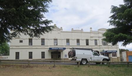
The
Imperial Hotel started in 1907.
The
Kent Brewery opened here in 1835 and closed in 2005. A community project
attracted artists from all over the world to reproduce advertising signs
ranging from 1895 to 1945 on the walls of local buildings. Obviously this is
one of them. The horse-drawn era ended after World War 2.

Drove
through town and up onto a hill to get a higher view over the Cement Works. The
first cement making started here after 1893. Portland was gazetted a village in
1894 and declared a town in 1906. The Cement Works opened in 1902. It is
estimated that almost 18 million tonnes of limestone were mined for use in the
cement works prior to its closure in 1991.

Back
into town where I found a train mural.

Got
a photo of the main buildings and chimney stack from behind the security fence.

Found
a few more old advertising signs and a lovely mural.


Back
on the main road at Cullen Bullen. Further on I had noted a lookout last year
so we turned into Pearsons Lookout which overlooks Capertee Valley. At 30
metres wide Capertee Valley is the world’s second largest canyon, being one
kilometre wider than the Grand Canyon, but not as deep. The lookout is at 907m
elevation and is 627m above the valley floor.

Not
the clearest due to the low cloud but still a magnificent sight.


Zoomed
in a bit on Mount Gundungaroo (789m) on left then the pointy one is Mount
Canobla (829m). Behind that is Glen Davis township and the ruins of the Oil
Shale Mine and the Coorongooba Campground (27km away) on the Capertee River.
Newcastle is 168km in that direction.

Pantoneys
Crown (1020m) is 9km away and is a geological formation called a Butte. Defined
as an isolated hill with steep sides and a small flat top, Pantoney’s Crown is
the remnant of volcanic rock that was left when the softer rock of the Capertee
Valley was eroded away over millions of years. The word Butte comes from the
French word meaning ‘a small hill’. Pantoney’s Crown was named after William
Pantoney, a member of James Blackman’s first party of Europeans to enter the
valley in 1821. Gosford is 128km away in that direction.

More
information.


Stopped
at the rest stop at Capertee (810m) – they have put in new toilets since we
were here last year. I had taken photos of the info there last year but I found
another one in the park beside it.

Down
into the valley past Airly Diamond Mine – should have stopped there! (a chap said that was a play on words as if
coal is left in the ground long enough it becomes a diamond – so coal is often
referred to as Black Diamonds!!) Onto the flat valley floor (260m) past lots of
green pastures. The towering escarpments were on each side of us.


Turned
off to check out the Campground first to have our lunch. Through private
property then over the causeway over Capertee River into Wollemi National Park.
We could see the oil shale ruins on the other side. Kept going down 3km to the
Coorongooba campground which was big and green. A couple of campers were set
up. Looks like they got a lot of rain here too. It is very popular with bird
watchers as the Valley is renowned worldwide for the many species here.


Good
map of the National Oil Shale Mine and Refinery.

Walked
down to where the Capertee River joins another creek but I can’t work out what
by my map. A kangaroo was having a nice time relaxing by the river.


We
are right below the sandstone cliffs here.


The
Oil Shale Refinery is on private property but you can go on organised tours on
weekends. There is a walk up from the causeway so we parked the car and went
for a walk.

Climbed
up the hill to look down on the site which is all fenced. Up
the top though there were buildings and the actual mine site that we could
check out.
Great
view down the valley too.

The
other side of Mount Canobla (on left) and Mount Gundungaroo.

Big
piles of tailings. The road was all crushed shale so it was all black.

The
whole refinery site below us.

Wandered
around checking out the other buildings that weren’t behind the fence. Tried to
figure it out looking at the little map on my camera. I think some of the
buildings here weren’t on the map.


We think these are surge bins.


We think these are surge bins.

This
one has collapsed behind it.

Mr
Goanna just wandered by. We saw one while we were having lunch. Steve called it
a monitor lizard so will have to google the difference between the two.

Up
into the bath house area. First we thought these were troughs but we now think
that had tops to them and were benches in the showers etc.


Steve
doing his daily business!!


Further
around and up the hill was the mine entrance. Oil shale was mined here since
1938, supplying the adjacent oil refinery until its closure in 1952.


Steve
pointed out where the flywheel would have been for the winch which lifted the
coal out of the shaft.

Lots
of wire rope by the lantern shed.

Headed
back down as the rain started to fall. A water lizard sunning himself on the
old pipe in Capertee River.


Back
out to where we turned off. Looking back up the valley towards the campground
area 3km away. To the left of the pasture were lots of old brick chimneys. When
the village was booming around the oil shale mine people were offered cheap
loans to build. Some built houses in the village and other built tent homes
with a brick chimney. When the mine closed, the people with homes were stuck
but the tent home people just packed up their home and moved on – bit like us
in the caravan I suppose!!

Cute
letterbox as we headed back along the valley floor.

Jon
rang about a job – great to hear from him and that all is well.
Climbed
back up to Capertee and then to the lookout again for a cuppa. Fabulous view,
though the clouds are moving in. Looks like they are getting rain at the
campground now.
Down
the highway to Cullen Bullen – tried to get a photo of all the garden gnomes in
this yard but it is a bit blurry.

Pulled
off at the RSL to read the history signs. Interesting that Cullen Bullen’s
aboriginal meaning is Lyre Bird. Lots of coal mining history here.


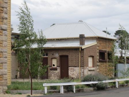
The
Cullen Bullen Royal Hotel was built in 1889.

Further
along was the story of the Invincible Colliery Skip Line which ran where we
were standing. The colliery has moved further down the highway now.


There
were a few old photos too.


Through
Lidsdale where the turn off to Wolgan Valley is - goes down to another old oil
shale mine at Newnes. Turned off at the Wallerawang Power Station which was
decommissioned last year. It was the oldest power station on the NSW
electricity grid. Seems a waste of all that machinery.


St
John’s Church was commissioned by the Walker/Barton family in 1880.

Stopped
by the lovely sandstone railway building in Wallerawang. It was originally
built in 1870 as part of the Great Western Railway Line, it was part of the
contract that included the Zig Zag construction. It was an interim railhead for
the Great Western Line, a passenger junction, service depot and coal handling
facility.


Across
the road was Hotel Royal – what a stark contrast to the lovely sandstone
buildings.

The
Clark’s Hotel further down the street looked much nicer.

Lots
of information about Wallerawang and the Mt Piper Power Station – might go
there tomorrow as there is a tour at 11am.


Colourful
lorikeet.

Stopped
at the Charles Darwin monument at the entrance to the Lake Wallace camping
area.


Got
back to the van just as the rain started but it was only light and didn’t last
for long. Sad news to hear Marion’s mother passed away.
Weather
said they had 40mm of rain at Zig Zag Railway Station which we must have been
near when the hail hit – The rain was so heavy we forgot to look for it. Looks
like it is going to get colder as the weather said 7 to 20 then 5 to 19 on
Friday. Hopefully the terrible storms will go before we head down to Camden on
Friday. Two ladies were hit by lightning strikes yesterday.
Rang Linda to arrange meeting up with her - dinner Saturday night. She offered for us to stay there too. Will check with Marion as she will have her mother's funeral to arrange so that might be a good idea to go to Linda's first.
Rang Linda to arrange meeting up with her - dinner Saturday night. She offered for us to stay there too. Will check with Marion as she will have her mother's funeral to arrange so that might be a good idea to go to Linda's first.
‘Back
to the Future’ day as this is the date they stated in the movie so they were
doing all the comparisons to see what the movie predicted and what is available
today. Some have happened but the hoover board is not happening except the one
Eddie tried out overseas. Great video by Pepsi Perfect with the PRA V8 crew on
Facebook. Must have been made before Chaz’s crash but interestingly it finishes
with Russell Ingall. Russell was racing with Holden at Bathurst while James
Courtney was injured and when Chaz was injured he was hired to race with
Cameron Waters in Chaz’s car for the Gold Coast 600. So they must have redone
the end to put Russell in it.
Googled goannas - The name goannas was given to Australian monitor
lizards by the early European settlers. They thought our monitor lizards looked
like the South American Iguanas. There
are over 20 different species, adapted to different habitats, and
interestingly they all look very similar. But there is a big difference in
their size. The largest Australian monitor lizard, the Perentie, can be over
two metres long. Its tiny relative, the short-tailed monitor, reaches all
of 20 cm.
All goannas are
dark (grey, olive or brown) and most of them show a pattern of lighter coloured
(grey, white or yellow) spots, rings, blotches or stripes. Those patterns vary
between the species, but also between younger monitors and adult lizards. Another
common characteristic is the loose skin on a goanna's neck. It makes the neck
look bigger than the head. If a monitor lizard feels threatened they can puff
up those flaps so they look more dangerous.
No comments:
Post a Comment