6am
sunrise – cool breeze. Lots of corellas squawking in the distance.


28
degrees at 7.30am. The boom boom has started to get rid of the birds on the
orchards.
Packed
up and headed south along the Sturt Highway to the Almond Hut. The almond
plantation we saw just before we came into SA is one of theirs. Bought some
cinnamon covered, hot & spicy and smoked almonds to enjoy with our
afternoon drinks.


Continued
down the highway (110km/hr) passed the Murray River National Park area of Lyrup
Flats. Of course there are fees for camping in the National Parks so we are
heading for a free camp near the Lyrup Ferry. They have left a few ferries
along the Murray so tourists can enjoy the experience of the bygone era –
though they are all modern ferries now. The first Lyrup punt started operating
here in 1918.


Down
into the SS Ellen Park just near the ferry. Parked under the trees as it is
going to be 38 degrees today.


Lyrup
is first and one of 11 settlement sites chosen along the upper Murray of South
Australia to become the homes for many unemployed men around Adelaide. 40 men,
their wives, 49 single men and 114 youths and children had been selected to
occupy the Lyrup Settlement. They were brought up by train to Morgan then along
the Murray on the SS Ellen which arrived here about 8am on Thursday, 22
February, 1894. The food supplies, bedding, furniture, tarpaulins (intended to
become shelter) etc were unloaded onto the riverbank. Iron timber, ploughs and
heavy items followed on the Paddle-steamer Gem. What an amazing experience for
them all. The settlers immediately set to work. Men went into the bush with
axes and saws to fell native pine trees to make the framework for shelters. The
women and some men set to work cutting and sewing the old, flea infested
railway tarpaulins. A baker’s oven was constructed and a vegetable garden was
dug. Seeds of turnips, peas, beans, cabbages, cauliflowers and seed potatoes were
planted within the first week. Our pioneers were willing to try anything. Sadly
a 10 year old boy drowned in a nearby creek on the 28th Feb so they
had to quickly decide on where to put the cemetery. Lyrup is the only village
of the 11where the Village Association still exists. Today the function of this
association is the ownership and operation of irrigation and drainage
facilities for the horticultural blocks now owned by the association members.
It also supplies domestic water to the Lyrup Village area.


Had
some lunch under the trees by the river as it was already 36 degrees in the
van. The other vanners are from Adelaide – they plugged into the power for $5 a
day so they can run their air conditioners. Must admit we put the aircon on in
the truck as we headed off to explore.

The
site of the first Lyrup pump near the park area.


Along
the road was the site of the second Lyrup pump.


Along
the back roads through the Gurra Gurra wetlands area. There was even a Tortoise
Crossing area.


Onto
Bookpurnong Road over Gurra Gurra Creek bridges.


A
steep climb up the cliff face onto the high ground then we turned off towards
Lock 4. Got a view from up high for a change.


Down
to the carpark.


Pretty
vine taking over the gardens.


Weir
& Lock 4, Bookpurnong, is 516 km from the mouth, 13.2 metres above sea
level and was construction completed in 1929. The maximum lift from the lower
pool is 3.4 metres. Each lockage at this head of water would release
approximately 4,850,000 litres of water. Interesting to note that the locks
downstream of the Darling River (Wentworth) are larger (83m) locks than those
upstream (51.5m).


The
flow meter and another flood height chart.

Looking
downstream.

Just
love the colours in the river red gums – though I should remember to take my
sunglasses off as the colours are much better with the glasses on!!

The
weir and looking upstream.


Information
about Katfish Reach – another style of fishway.


The
Salt Interception Scheme.


The
lock master’s house.


Back
out to the main road then we turned straight away to travel down the side of
the hillside towards the Murray, upstream of the Lock. Across the Murray is
another part of the MR Nat Park called Katarapko.

Followed
the road down to the end to look at Booky Cliffs.


Back
up the main road towards Berri. Berri began as a sheep station in 1910.Over the
bridge spanning the very wide Murray River.


Unusual
Info Centre on the riverfront.

Stopped
to check out ‘A Special Place for Jimmy James’, an aboriginal tracker who
helped the police a lot. Nice spot – the dead trees would have been on the
original river bank before the Lock raised the river level.

Jimmy
was named South Australian of the Year in 1983 and awarded the Order of
Australia in 1984. He passed away in 1991 (born about 1910) and is buried at
Gerard Aboriginal Reserve. Nice spot and the mural is so shiny the river is
reflected in it.


A
bit further along was a boat ramp into a pond off the Murray. All this would
normally have been dry except that the Lock keeps the water level up now.

Walked
back to the truck – looking up at the bridge.

An
old pump but no info about it.

Even
though it was hot we decided we needed the exercise – hopped on the scales this
morning!! Continued along the riverfront. What is now used as a boat ramp used
to be the ferry crossing up until 1997. The round concrete thing held the wire
rope. Looking across to the other side.


Droughts
and Floods – bit hard to photograph as it is shiny and the plastic over the top
has been scratched up. The Murray River around Berri has an average width of
200m and an average depth of 6 metres.

The
Berri Resort Hotel and foreshore.


Berri
origins and photo of the foreshore in the 1920s.


Riverfront
and Recreation – we think these are the steps down to the Olympic Pool they had
created beside the Murray – as there is a sign saying ‘Beware submerged
structures’.


Paddle
steamers and river trade.

Wallis
Terrace – fancy living in those tents.


Surveyor’s
bench mark – marking the commencement of the Berri Bridge construction.


The
pumping station.


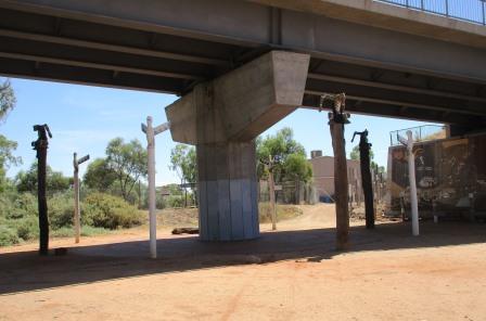
Walked
over the pipes to under the bridge.

It
took over 30 years of lobbying the government to get a bridge over the Murray
here as the queues to use the ferry were getting so long. It is designed that
if one of the piers is knocked out the rest will hold the bridge up.


Under
the bridge was a mural of aboriginal dreamtime.


But
don’t get too close!! Though it looked like someone’s worldly possessions were
scattered everywhere.

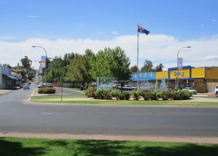
Back
along the riverfront – looking up the main street with the War Memorial in the
middle.


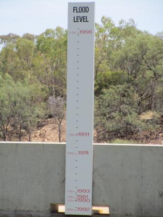
At
the Info Centre we found the flood marker by the water.

Another
one of the River Boat Trail boards showing where the wrecks are and why there
aren’t any Murray Cod left – looks like a photo of my dad with the barra he
caught up north!!


Lovely
mosaic chairs along the walk.

Checked
in the Info Centre for more brochures and maps and Steve asked about the speed
boat USA v Aust race this weekend - $25 and $30 a day to come and watch.
Back
to the truck for a cold apple and water – got a bit warm out there!! Drove down
to Martin Bend where the ski club have a lease over some riverfront then there
is a cheap camp area $5 per night but back in the bush – no water front views
here. We have been spoilt with our campsites so far.
Back
into town and up the main street lined with pine trees.

We
thought they were art work but I think it is a climbing frame for whatever is
growing inside.

Stopped
at the water tower that is now a lookout. 100 stairs up!! The last ones were
inside the tower.


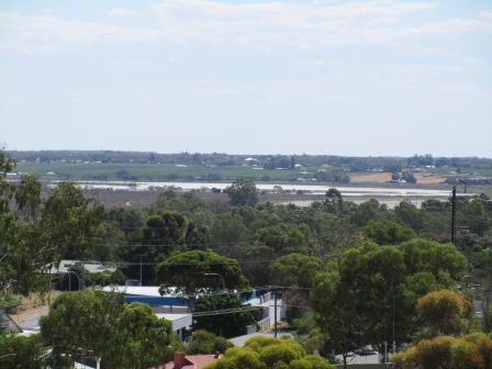
Nice
view over Berri and the Murray River.


Zoomed
in on the Booky Cliffs.

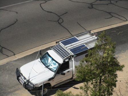
Good
time to check out the top of the truck is all ok. Our $1.50 windscreen
reflector has been a godsend.
Part
of the wetlands.
Continued
on the Old Sturt Highway to Barmera and Lake Bonney.

Went
down to the water’s edge for a cuppa under a shady tree. You can camp along the
edge of the lake where it isn’t lawn or fenced – so that will be the scrub area
on the other side.


Around
the edge to the Information Hut. The lake is fed from the Murray River through
Chambers Creek wetlands.


Drove
into the tracks checking out the camp spots. Found a few but there isn’t much shade so might
come late one arvo so we can watch the sunset and sunrise and then head off
before it gets too hot. I think my little camera takes some wonderful photos!!

At
the northern end of the lake is site of Napper’s Lake Bonney Hotel.


The
store and cellar have been completely vandalised.

Across
Nappers Bridge over Chamber Creek. I see on the map there is a Pelican Point
further down but at the moment I think they are all here.


Back
on the road and into Glossop where I managed a few photos of Berri Estates
Winery which has been a fundamental part of Berri’s existence since 1918 making
it one of Australia’s oldest wineries. Berri is surrounded by 3000 hectares of
irrigated vineyards and orchards.


The
tall date palms stand out.

Across
the bridge and down Old Ferry Road – the other side of the ferry crossing.

6pm
and back to the truck and it feels like midday (40 degrees in the van)!! Had a
drink and some of our almonds while the birds entertained us with their
chatter.

One
water hen and some ducks came to visit too.


The
great maps they have for each area are really good.

Erica
rang, returning our call. All well there.
Sat
outside for dinner and watched TV till 10pm then cold shower and off to bed.
Nice spot but the ferry is 24 hour so between that and the street light we will
be happy to be back in the bush!!
No comments:
Post a Comment