Lovely
fresh morning, 25 degrees at 8am. So lovely to sit by the river eating
breakfast.
Uploaded
my blogs and facebook and noticed my cousin Roz had put up one celebrating her
parents Diamond Anniversary, 60 years married – wow. Gave John and Jocelyn a
call to congratulate them – he has a few bottle of French champagne they are
going to celebrate with later.
Steve
had a visitor wander by.


Packed
up and headed along Red Gum Track beside the Murray. Another goanna going for
his morning walk. Then a big lizard.


Stopped
further along the track and walked down to another nice camping area – it was
over a hump then down to the water’s edge so we walked in case we couldn’t get
the van around.


Lots
of lovely parrots in the trees – Steve found a colourful feather for me.


Big
nests up high probably for the Whistling Kites.

Back
onto the bitumen and through Yelta, more grapes and citrus trees. Crossed over
the Murray into NSW. Still a single lane version with the lift section for the
boats.


Onto
the Silver City Highway to Wentworth. First we cross Tuckers Creek.


Then
the Darling River. It is a modern bridge but still has a lift span in it.


Stopped
at the Info Centre and found out we can camp at Thegoa Reserve beside the
Murray just west of town. She also said that the water in the Darling River is actually the Murray - it is pushing upstream from here about 40km then it is dry. The Darling has flowed since 2011 floods. Found a nice spot by the water with a great view of
Lock 10 and Weir.


Made
some lunch and sat by the water’s edge. A houseboat came by and we noticed the
lights on the Lock had turned green. We jumped in the truck and got up to the
Lock just as they entered.

I
went through the gate to get a photo then Steve said ‘didn’t I read the sign –
Authorised Personnel only’ – Oops. Got a good photo!!


Dashed
back out behind the big fence to watch the process of filling the lock so they
could head upstream.


The
chap had a remote control to close the gates.

Then
the water started rushing in.

As
the boat rose I took a photo across the weir. We can’t go out onto this one but
I asked the guy and we can come in from the Vic side to see it so will do that
when we head that way.


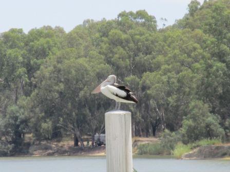
Mr
Pelican having a rest. You can just see our van behind the post.
Up
she comes – nearly at the top.


The
other end opens and they head off.


I
had to run through the sprinklers to the other end as they headed upstream.


At
the upstream end of the Lock was a monument to Captain Charles Sturt who passed
this spot on 23rd January, 1830.

More
info. Lock and Weir No. 10 is 830km from the mouth, 30.8 metres above sea level
and was completed in 1929. Below the lock it is 27.6 metres.

The
fishway is on the far side – the sign needs redoing.


The
chap didn’t quite get the gates closed properly – got a bit of a leak.

Looking
downstream towards the van.


Headed
back to the truck – looking back over the lock and weir.

On
the other side of the road was a nice picnic area beside the cemetery.

Turned
back and I noticed a jetski had come into the lock then his mate and finally
another houseboat, all heading downstream.


The
jetskies moved around as the water dropped.


They
zoomed out once one gate was opened.


The
boat is below is now and made its way out. The fishermen have been there for a
while.


As
we drove off I saw the Flood Level sign – the top one was in 1956.

Back
to the van for a cuppa. The Info Centre lady had given me a great brochure on
Inland Shipping.


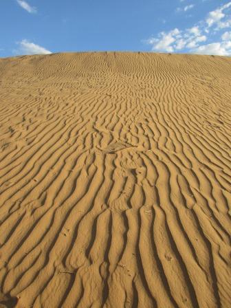
Cooked
dinner early then headed north to check out Perry Sandhills. The hills were
named after George Perry who was the first land commissioner to serve this
area. According to geologists, the Perry Sandhills originated after an Ice Age
(40,000 years ago) and were formed by wind erosion over thousands of hears.
Skeletal remains of giant mega-fauna (kangaroos, lions, emus, wombats and a
giant goanna) have been found here. The Sandhills were used as a bombing range
during WW2 and the area has been utilised as a backdrop in many films, TV
shows, advertisements and theatre/music presentations. The surrounding area is
so flat so it is so strange to see this group of sand hills – we could be in
the middle of a desert. We drove around the outer edge on the flat – probably a
couple of kilometres around.


A
couple of roos jumped away from us.


I
climbed up the first one for a photo as Steve was checking out the amenities!! He should have closed the door!!


Looking
across the other sand hills.


The
flies are lonely out here as they have all arrived to say hello!!

This
River Red Gum tree is over 500 years old and is known as the God Tree. Her
trunk is buried in the sand allowing us to stand in the canopy of the tree.


Had
a ball taking photos.


Steve
found some cardboard to try and slide down the hill. First he had to climb up
it – got a video of that effort and then videos of him trying to get down – got
bogged!!


I
went down the bottom – looking straight up.
Steve’s
turtle trail!!

He
went over another hill and found a toilet seat so thought he would try that –
no better.


The
wind was picking up and lifting the sand over the dunes.

Down
to the old tree for a photo.


Steve
headed back to get the truck and bring it around closer so we could have a
cuppa while waiting for the sun to set.

We
were in a dip so couldn’t quite see the sun - I took a photo through my
sunglasses as it looked much redder with them on and looked like it had set.

8.40pm,
we climbed back up the high dune to watch the sunset. It was still up high.

The
glasses are good though – then without.


Nice
bit of colour on the dunes behind us.

So
pretty.


Finally
down.


Our
footsteps along the top of the dune.

Back
to the van for a pretty view of the Weir. Off to bed with the sound of the
water cascading over the weir.


No comments:
Post a Comment