7.30am
23.6 degrees, overcast. Headed back up the 40km of dirt road to the main
highway again. Warming up quickly though we are still travelling with the
window down rather than the air conditioning.
Not
far up the highway we met the Road Closed signs due to the Phillips River
bridge being washed out in the recent floods. Turned north onto the dirt detour
road for 48km of gravel till we get to the Newdegate Ravensthorpe Road.
The
sky has cleared as we got to the bitumen again near the Mt Madden wheat bin –
we have passed a few of these, big storage areas. A flashing sign said 2WD
detour to left, trucks and 4WDs go right so off we went. This is why no 2WDs as
the road is still under water.
Wasn’t
too deep. There were ducks paddling in the water as we went through.
This
blurry shot is of Lake Chidnup which is very full and probably why the water is
over the road.
Spotted
this artwork as we headed towards Ravensthorpe then remembered reading about
the Farm Gate Art Trail – a collection of fabulous sculptures, mainly crafted
by locals from farm scrap metal and themed around local wildflowers and fun.
Passed
the Galaxy Lithium Mine site – big open cut area. Gold was found around the
Phillips River in the late 1890s but I don’t think we will be detecting here.
There were more than 90 gold & copper mines in the goldfield – now there is
minor gold activity but great prospects in nickel, cobalt, spodumene, pegmatite
and silver. Back to the South Coast Highway again then turned east. The big
grain silos greet us at the entrance to Ravensthorpe.
Stopped
at the Information Bay where we could fill up with water.
The
120degree East - WA time meridian line. There is a plaque for it on the west
side of the highway but that is closed due to the bridge. I noticed that it
runs through East Mileys Beach so we were standing on it there (each map spells
Miley differently).
Diagonally
across the road is a park beside the Telecom exchange which is available to
self-contained RVs for overnight stay. We parked there so we could go exploring
and stay for the night. Temp in the van for lunch is 30 degrees – yeah summer
temperature for the last day of summer!!
Drove
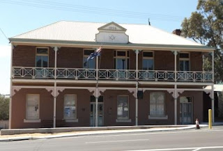
to the IGA for some fresh vegies and eggs. There are a few old buildings in
town like the Palace Hotel (circa 1906). Built using local brick and features
Jarrah furniture and staircase, a stunning Edwardian stained glass window in
the stairwell and stamped metal ceilings reflecting the prosperity of the
period.
Across
the road from our camp is the Freemasons Lodge (1906).
Stopped
in at the Info Centre for road closure info – only one further east with about
5km of dirt road. There is a museum here that I might explore when we come back
here. Put the groceries away then headed onto the heavy vehicle bypass to
follow the Ravensthorpe Range 4WD scenic tour (27.8km) up and along the
Ravensthorpe Range. The stonewall is the only remains of the once gold-rich
Floater Mine, discovered in 1899. Now it is surrounded by farmland.
The
trail info lists all the plants we will see along the gravel drive. The range
has the most eucalyptus species in the world for its size. Up the hill to the
lookout at 402m above sea level. The track continues on up the hill.
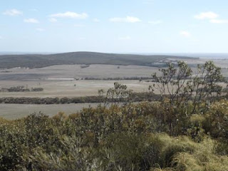
Nice
view across the farmland, over Ravensthorpe and the lithium mine to more
farmland of which some are canola fields.
Zoomed
in on the mine.
Ravensthorpe
nestled in the trees with the silos as a good landmark.
Continued
up the track to 450m at the radio tower then down the other side with another
great view looking south.
The
road is now 4WD with lots of rocks protruding due to the recent rains. The
booklet info is accurate with the different plants though I didn’t get to see
the Qualup Bell the town is known for as it probably only blooms in spring but
I got the photo out of the booklet.
Up
and down the range’s hilltops then we passed a railway crossing sign!!
Someone’s practical joke – there is a motorcross track nearby so it might be to
do with them. Down onto the flats and the recent rains have left their mark
with the track eaten out. Fell into one hole but Steve got us out and we drove
around it through the bush.
Further
along we passed a clearing where a vineyard was started in the 1970s – the
kangaroos ate the vines, the birds ate the fruit and the owner drank the rest!!
So the brochure says – it also said to look out for mallee fowl but we found
emus instead. Of course they would rather run down the road then through the
bush.
We
stopped as Steve noticed an interesting tree. The booklet says it is a Fushia
gum (E. forrestiana), distinguished by four distinct wings on red fruit. They
were planted by the vineyard owner.
Continued
on till we came to a hillside that was eaten out but Steve saw someone has been
up before us so off we went. Unfortunately one tyre decided to fall into a rut
halfway up so I just sat quietly (didn’t even take a photo) while Steve got us
out!! As he says, “that’s what this truck is for”. When we reached the top I
noticed a sign facing the other way that said ‘Danger’ – oops!
Into
an open area with lots of Salmon Gums (E. salmonphloia) – great trees for
hole-nesting birds and bright salmon-coloured trunks in autumn.
Back
onto the bitumen again – looking back at the range.
At
the east end of town is the historic railway station. Stopped there for a cuppa
– Steve inspected the truck, no damage!!
The
info was very faded.
In
the brochure it says there are two Norfolk Island hibiscus trees (pink trumpet
flowers in summer?) – well I presume so as this is one of the two standing on
the railway station.
I
think this field would be canola.
Back
to the van and I walked up the street to check out a few history items in the
booklet. First was the ceramic mural, created by artist John Way in 1999, for
the celebrations of the centenary of Ravensthorpe & District (1903-1961
formerly known as Phillips River District). In his studio John designed and
potted 120 tiles set in ten panels to depict historic events of the district.
Unfortunately someone has planted a climbing rose in front of it which is
covering up the mural.
Pre
1848 – local aboriginal tribesman Wadjuri, bushland and wildlife.
1848-1872
– pastoralists and prospectors.
1898-1901
– Gold rush.
1901-1911
– Mining, building boom and farming.
1912-1920
– Local Government, Great War (1914-1918), smelters and farming.
1920-1939
– Railway and jetty closed – depression.
1939-1969
– World War II, Flying Doctor, school bus, resurgence of copper mining and new
land farming.
1970-1982
– sport, resident doctor, National Parks, wildflower show and co-operative bulk
handling.
1983-2000
– Satellite reception, road trains, swimming pool, extensive wildfires, restoration
of Commerical Hotel to Community Centre, Entertainment Centre, nickel mining,
floods and drought.
Walked
down Federation Path to the Community Resource Centre – it was original the
primary school building from Fitzgerald that we called in at. It was brought
into town in 1997 after the school closed.
Lots
of ‘art’ flowers everywhere and in the main street the flowers are lovely. They
are currently laying new pavers and making the town look very neat after all
the rain.
Opposite
the Palace Hotel is the Shire Office. It was originally the Western Australian
Bank which was built in 1906 using imported bricks from Germany. In well
preserved condition it has stamped metal ceilings, jarrah timber work and
features stained glass windows.
Royal
Hakea artwork in front of the Police Station and Courthouse. The first
policeman, Corporal John Wall, pitched his tent at the rear of this building
under Salmon Gums in 1900. The Post and Telegraph Office (1901-1993) burnt down
on 1st August, 2016.
Steve
got TV reception but it is only ABC. Watched some news – not that it is
interesting and then watched a program about rum distilling which was very
interesting. Another van has pulled in and a couple of whizbangs (has sliding
doors that go whiz-bang).
Cloudy
again.


No comments:
Post a Comment