Weather
forecast for top of 28 today for the 1st day of Autumn. Lovely clear
sky as we head east on the highway. The road has taken a beaten from the recent
floods – though it isn’t the best highway in the first place. You can still see
all the rubbish in the trees where creeks have swollen and the paddocks eroded
by the rushing water.
Crossed
over Jerdacuttup River which flows south to the ocean east of Hopetoun. My photo
was too fuzzy but the river area was eaten away but this bridge stayed intact.
Got the remains of the guard rail. The lady at the Info Centre said the
Phillips Bridge has washed away 3 times so far – apparently the approaches wash
away and undermine the bridge. She showed us photos of the bridges and flood
area – certainly got some water.
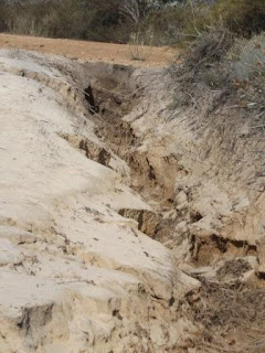
This
area copped a lot of damage through farmland etc. The farmer has lost some land
here as his fence is hanging in the air.
Further
along we saw the FQM Australia Nickel Mine near Bandalup Hill.
A
section of the highway is still closed so we detoured onto Fence Road for 5km.
This
road follows the No 1 Rabbit Proof Fence down to Starvation Bay which is the
southern point. I had picked up a brochure from the Info Centre. Saw the fence
as we turned and a sign about not being allowed along the fence route. Will
check out Starvation Bay when we return.
Turned
onto Jerdacuttup Road which is bitumen but has lots of fixed up washouts. Lots
of water still lying by the road and creating lakes where fields used to be.
Across
a causeway for Yallobup Creek.
Back
to the South Coast Highway again and the road closed signs. I saw an info board
so we turned towards the road closed sign then a police car came up behind us.
Luckily we were turning into the info bay and he went to the road block.
Lots
of things still to do when we come back to Ravensthorpe and Hopetoun.
Continued
along the highway – more repairs at Oldfield River bridge. This river joins
with the next one, Munglinup River, and flows to the sea at Munglinup Beach
where we are heading to.
Passed
the turn off to the little township of Munglinup then turned down Fuss Road
which was bitumen. Only narrow and it will need some repairs as there are few
of these eroded spots.
Turned
onto Springdale Road where the east section of it is closed. Down to the beach
road which was dirt and eaten away and quite corrugated.
Over
a rise and we got a glimpse of the Oldfield River.
Stopped
at the info board further along. There is a track beside it that heads down to
the river.
The
fields opposite are covered in little yellow flowers – probably a weed but
looks nice.
Nice
campground with allocated bays. We chose one closest to the beach access as the
campground is behind big sand dunes.
Chatted
with a young guy next door from Adelaide who is finishing his year of
travelling. There is another big motorhome pulling a trailer with his 4WD and
4-wheeler in it – only a young couple. Another chap had a little car, tent and
an ultra-light – not the usual thing you see being towed around. Didn’t see him
to chat to him about it.
Went
down to the beach which is a lovely bay protected by a rocky reef.
Zoomed
in on Powell Point to the west.
The
water is so clear that I easily spotted 5 salmon and some herring swimming in
the shallows. They are the dark shadow in the middle.Will come back with our
rods and see if we can catch lunch.
Walked
around our point – more lovely beach around to Powell Point.
Mr
Shag was drying off on the rocks. The water is rushing around the rocks –
should be fish in there.
Looks
like the kids have fun on the dunes.
Got
our rods and headed back to the beach. Unfortunately the salmon had disappeared
but I managed a small flathead. We walked back the other side of the bay and
Steve got a herring then a black fish we would call a parrot fish but we think
they call it a groper. I got another small herring which we released – they
were small!! As Steve’s fish had swallowed the hook he became lunch. Lovely
white flesh and tasty too.
Did
some blog while Steve read till smoko. Big black clouds came over and dropped a
couple of raindrops on us. Rick rang to say he and Kaylene are coming to WA in
December. They are staying in Mandurah and invited us to join them. That will
be lovely.
Drove
back to the info board and down to the river. The tracks are eaten out so we
parked and walked down.
Rocky
bank with water still seeping out of the sand.
Evidence
of the high water level.
Very
dark tannin-stained water.
We
tried another track which was supposed to go to a lookout but it was narrow and
very sandy so we turned around and headed back.
Stayed
cloudy and a bit warmer.


No comments:
Post a Comment