7.30am
13 degrees. Check the weather and it is supposed to be a fine day but still
overcast here. Dug out our waterproof pants to do the walk down to South Cape
from Cockle Creek.
As
we drove out I noticed the gateway sign – Memorial Park. Will change the labels on the blogs.

Drove
straight down to Cockle Creek. It is still overcast with darkish clouds and
cool. Had a cuppa in the car park looking over the bay. A few people have just
hiked out from doing the 8 day trek – good on them!!
Chatted
with the National Parks Ranger about the whale Penny & Pete took a photo of
yesterday, dead on the beach. She said it was a Pygmy Killer Whale after
googling it. The ranger said he had called the whale people and they had
removed it.
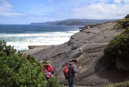
Headed
off up the South Coast Track (8days trek) – they don’t do signs well here as
the sign for the South Cape Bay is further up the track and the sign in book is
350m along the track. We have 7.7 km to walk to get there. This will make us
decide if we want to try to do the 17km walk to the southern point of mainland
Australia!!

The
track had some boardwalks then onto the ground which was quite wet, even
flowing in some spots.
.JPG)
.JPG)
.JPG)
Eventually
after up and down small hills we came out into the valley – not a strenuous
walk but need to be looking where you put your feet all the time with rocks and
roots and mud ready to slip you up.

Huge
tree down and moss covering everything here.
.JPG)
.JPG)
Boggy
going as the trees don’t let much sun through here.
.JPG)
.JPG)
Onto
the board walk along the valley. We passed a Dutch chap and French lady
(younger than us so we are feeling good).

Looking
back to where we have travelled.
.JPG)
.JPG)
Steve
said zoom in on that mountain – it looks like snow and it was!! Wow. We are in
long sleeve shirts and jumpers and have raincoats in the backpack but no snow
skis!!!
.JPG)
Further
along a better view at the snow.
.JPG)
.JPG)
The
boardwalk keeps on going which makes for easy walking as long as you don’t fall
off as it is very wet and the boardwalk is a bit wobbly.

An
old fenceline.

Climbed
a ridge and down again to the river which of course is flowing well.
.JPG)
.JPG)
.JPG)
Along
the ridge following the creek though it looks like it is flowing the way we are
heading it actually flows back to into Cockle Creek (or is Cockle Creek).
Lovely waterfall that would not usually be flowing this well.

Back
up the sandier ridge. We can hear the ocean roaring.

We
made it to South Cape Bay – looks lovely now as the sun is out and the sky is
clear and blue. Took us 2 hours to here.

Down
the stairs and onto a barren black cliff area – looks like coal, shale?
Zoomed
over to Soldier Bluff.

Down
onto the cliff area to walk around and down to the beach. Windy and cool but
not as freezing as I thought it would be.
.JPG)
.JPG)
Looking
across the Great Southern Ocean to Antarctica!!!

A
sailing ship going around the South East Cape which is the southernmost point
of Australia.
.JPG)
.JPG)
.JPG)
then right


The
rock piles marked the walk around this black barren point to the stairs down to
the beach.

.JPG)
Shame
they don’t have a “you made it’ sign so we will use the rock piles as one.
.JPG)
.JPG)
.JPG)
Further
around to the stairs.
.JPG)
.JPG)
Looking
back to where we had just walked around.

Going
down.
.JPG)
.JPG)
On
the rocky part of the beach. The cliff edge looks like a turtle face with a hat
on it.
.JPG)
.JPG)
Round
rocks then sand.

I
had said do you really want to do the stairs and Steve said “we have to so we
can put our hand in the water so say we made it!!!” That is what we did.
.JPG)
.JPG)
Then
the wave came crashing in and chased us up the beach.
.JPG)
.JPG)
Close
up of South East Cape.

Found
a rock so neatly cracked in half – looked like an IPhone or flip phone!!!
.JPG)
.JPG)
Found
a “comfy” rock and sat for 15mins enjoying our wrap, apple then a Cherry Ripe
for him and Mars Bars for me – reward!!
Back
up the stairs made from the rocks – quite amazing really. If National Parks did
this I don’t mind paying my pass fee then.

View
back along the beach to Lion Rock – decided we didn’t need to walk all the way
down there as we still have another hike after this one to do. Good luck to
those doing the 8 day hike!!!

Certainly
some rugged coastline.
.JPG)
.JPG)
A
boat disappearing between the rolls of the waves.

The
only wildlife so far has been lizards sunbaking on the boardwalks. This chap
didn’t move as we climbed over him. Some black cockatoos squawked up in the
hills.

Years
ago when we took the boys to Cape York they did topless at the top so I was to
do bottomless at the bottom – started but too cold!!! Lucky I had my leggings on under the waterproof pants.

Up
to the top and along the track to a spot where you could camp – nice view to
South East Cape from here and over the beach.
.JPG)
.JPG)
Passed
a man and his son carrying surf boards. The other son had dropped his board and
broken the skeg so had run back (1 ½ hour) back to the car for new ones. Oh to
be young – but I wouldn’t have done that then.
Up and down again till on the boardwalk again. The snow is still on the mountain. Will have to check the map to see which mountain it is.
Up and down again till on the boardwalk again. The snow is still on the mountain. Will have to check the map to see which mountain it is.

Passed
the young chap with his skeg and a few spares. He still has another 1 ½ hour to
go before he gets into the ocean!! So worried I would find him fallen over with
a broken leg from rushing. Certainly has warmed up in the sunshine so stripped
off our jumpers but still had the long sleeve shirts on. Met the lady we passed
as she was coming up from the cliff face. She looked exhausted. Commented that
she was taking it steady and she said not bad after not having been able to
walk much 3 months ago!!!
Back
to Cockle Creek.

The
soldier crabs were everywhere.

Checked
out a shack right beside the track and the edge of Cockle Creek.
.JPG)
.JPG)
Back
to the car for a cuppa in the picnic area. So glad to sit for a bit. Read on my
map that South East Cape is closer to Antarctica then it is to Cairns!!!
The
bay is just so flat, blue and beautiful – would be a lovely place to camp – oh
yeah – we didn’t think that when we came down and it was pouring with rain.
.JPG)
.JPG)
Zoomed
to the whale sculpture that is a 10 min walk from the next car park.

Some
more permanent shacks – wonder what it costs them to keep them.

Steve
rang Brian to catch up and see how business is going etc. I wandered over to
the big fly wheel and information about the Heather Family’s Cockle Creek Mill.
There were about 10 timber mills in the area. There was a wharf here too. Amazing.
.JPG)
.JPG)
Such
interesting reading – hope you can read it. Shame they don’t keep this info
boards maintained.
.JPG)
.JPG)
.JPG)
.JPG)
.JPG)
Drove
down to the car park and walked down to the Whale Sculpture over the bitumen
road – must have been put in so they could get the sculpture in place. It is a 3
month old Southern Right Whale, made in 1995.
.JPG)
.JPG)
Info
map of area and walks. We had crossed over the Heather and Cockle Creeks on our
walk.
.JPG)
.JPG)
Couldn’t
get close to the info about the whales as it was full of water so zoomed in –
came up ok to read. They were called Right whales as they classed as the Right
whale to catch.

Another
board about the mountains. The one we saw with the snow is Mt La Perouse and
has an almost permanent snow cover (1157 meters). Glad the Roaring Forties are
having a rest today – had enough of them in Geeveston yesterday.
.JPG)
It
is on the left (didn’t realise I had photographed it till I looked at on the
computer), then the Cockscomb and Mt Leillateach which looks like the Pyramid.
.JPG)
From
left is The Hippo then Moonlight Ridge.
.JPG)
Then
Moonlight Flats to the Calf and Adamsons Peak in the distance with Lune
Sugarloaf in the foreground on the right. You don’t notice the mountains when
you are driving because the road is lined with high trees either bush or
forestry plantations.
.JPG)
More
information about the French explorers. Lucky they didn’t settle as we would
all have been speaking French now.

Couple
of pose shots with the whale.
.JPG)
.JPG)
Looking
up the bay to the open waters and the bottom of South Bruny Island in the
distance.

Back
up the road a bit we turned onto the track to Fishers Point (2 hour return) –
it said easy!! It was along the beach but then you had to climb over the rocks
on the points or up through the grass or scrub around a few bays. The
next point is called Snake Point – 1793 Observatory of ship Recherche then
whaling station. Because of
the rain there were a few “creeks” flowing out of the scrub along the beaches
so we had to jump them too.
.JPG)
.JPG)
.JPG)
We
think this is a cockle that the area is named after. They are the most common shell here.

Another
shot of the mountains.

Steve
spotted the boards so wandered up for a look. It was a solitary grave of Samuel
who died on board a ship many years ago – hard to read the date.
.JPG)
.JPG)
Found
a perfect shell but it was still occupied so Steve tossed it back into the
water.

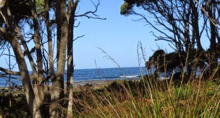
Up
and over again through a cool piece of scrub.
.JPG)
.JPG)
.JPG)
The
black and yellow cockatoos weren’t happy about our visit.

Looking
back across Recherche Bay to Moss Glen
which was a former timber hamlet (Smith & Heather Mills) plus a coal mine
and wharf and the site of the first watering place of the French explorers in
1792.
.JPG)
.JPG)
Lovely
sandy beaches across the bay but it is part of the Southport Lagoon
Conservation Area so no roads go into that area.

Looking
across to South Bruny Island.

More
rocks till the sign.


Glad
they had that or we wouldn’t have found the ruin. Not much path clearing here.

The
house was pretty big and was also the pub going by the info on the board.
.JPG)
.JPG)
.JPG)
The
locals complained about the unruly patrons though.

Great
views from the house though. View over bay.

Then
out to the ocean.
The
new beacon now does what the pilot used to.
Wonga
Mick’s apprentices have been here – lots of rock piles.
.JPG)
.JPG)
They
have the balancing just right too.
.JPG)
Zoomed
in on the lighthouse at South Bruny that we climbed to on that windy day.

And
the beacon further round.
The
kelp grows well here though there is heaps of it dried on the shore.


Steve
found a bone – maybe from a whale!! As there are supposed to be some here.

Across
the rocks to the Point.
.JPG)
Steve
added to the rock pile.
.JPG)
.JPG)
.JPG)
Headed
back. The tall trees are thriving now they are being cut down anymore.
.JPG)
.JPG)
Lovely
view back over Recherche Bay to Cockle Creek.

The beachcomber found some
old crockery!!

We
think he is a relative of the Pied Oyster Catcher but he is all black.

Interesting
trail – it was Steve dragging his walking stick then poking it in the sand.

A
poor crayfish didn’t get to grow up.

Back
to the bigger creek – Steve thought he could use the log to get across.
.JPG)
.JPG)
Worked
for him but as I went it nearly tipped me into the drink!! Steve had put his walking stick into the sand to balance and it nearly disappeared.
.JPG)
Steve
playing in the squeaky sand.

Back
to the truck at last – we do love our trusty walking sticks.

I did a quick run up the steps to see where the path lead – down a lot of steps to the beach. Gave it a miss. We have decided that this will do us for the bottom of Australia experience. Don’t need to do the 17km one way hike at Wilsons Prom now. (Don’t think we could make it anyway!!)
I did a quick run up the steps to see where the path lead – down a lot of steps to the beach. Gave it a miss. We have decided that this will do us for the bottom of Australia experience. Don’t need to do the 17km one way hike at Wilsons Prom now. (Don’t think we could make it anyway!!)
Back
over Cockle Creek then stopped to explore the cemetery – well I did – Steve
stayed in the car.
.JPG)
.JPG)
.JPG)
.JPG)
The
last person to die here was working at a coal mine so maybe that was coal out
on South East Cape.
A
lot of campers had left when we drove in but a lot more have turned up as we
drive out.
Tried
to get the view down the valley to Huon River on the way home – big blurry. No
room to pull over – would be a great spot for a lookout.

My
lovely shells I collected – can’t help myself. The little abalone shells have
such lovely mother of pearl colours and the other two were just perfect.

Back
to the van at 8pm for dinner. Missed the sausage sizzle with the others but we
are too buggered so just heated some chicken tenders and quiche in the oven.
Put the hot water on for a nice warm shower as it is getting cold again. I
wandered down to the others for a chat around the fire for a bit while Steve
rested his feet.
Going
to be a cold night again.
No comments:
Post a Comment