Woke
to heavy rain at 7am. By 8am it had cleared so we packed up and headed off.
Lovely view as we leave.

Stopped
at Margate to read the Huon Trail sign. In 1802 two small French ships moored
in the bay here. Interesting history.

Down
to Kettering and lined up to board the ferry.
.JPG)
.JPG)
.JPG)
We
had the best view as we headed across D’Entrecasteaux Channel, unfortunately it
was a rainy day but at least it was calm.
.JPG)
.JPG)
15
minute trip then we were disembarking at Roberts Point.
.JPG)
.JPG)
.JPG)
Past
a cherry stall then up a hill – yes even Bruny Island is covered in hills.
Turned south past lots of open pastures. The rain keeps coming across in scuds.
Looking over Great Bay. Will check it out when the sun is shining.

.JPG)
Onto
the thin ‘neck’ between North and South Bruny and onto dirt road. Now the truck
and van will be dirty!! Past the Penguin Rookery and into The Neck Campground.
A caravan was pulling out so got his nice flat spot and set up in between rain showers.
The sun peaks out for a bit then down comes some more rain. I prepared Lamb
Shanks in the Ecopot for tea then Steve tried the TV to see if we get
reception. All else fails we can watch the New Year’s Eve fireworks on TV.
.JPG)
Lots
of walks etc here so we will be busy for a few day. That’s if we get some
better weather as the weather forecast at 2pm said 40 knot wind gusts this
afternoon with rain covering Tasmania – yeah!! Can’t have perfect weather all
the time. Listening to the sad news about the plane crash into Storm Bay who
were following the Yacht race. That following the other airline crash – sad end
to the year.
Read
all the info – The island was first sighted in 1642 by Abel Tasman. Captain
Cook visited Adventure Bay in 1777 with the ships “Resolution” and “Discovery”.
Captain Bligh visited Bruny four times and it was from here that he left on the
“Bounty” for Tahiti, sailing towards the famous mutiny. The French explorer
Bruni D’Entrecasteaux (after whom the island is named) also visited in 1836 at
the southern end of the island. John Archer, the colonial architect designed
the lighthouse and 13 meter tower at Cape Bruny. The tower was built by convict
labour from local stone.
Went
for a walk to the beach of Adventure Bay which faces the open ocean below Storm
Bay. Looks beautiful at the moment as the storm clouds are behind me.
.JPG)
.JPG)
.JPG)
Looking
north to the Big Hummock where the penguin rookery is.

One
patch of the beach had heaps of shells. These flat ones we get at Woodgate and
make a great wind chime. We collected a heap so might make one!!

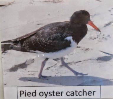
Haven’t
seen these birds before. (Found out at the Bruny Lighthouse Museum that they
are Pied Oyster Catchers.)

The
sea is lovely and clear though the wind is freezing.
Decided
to go for a drive and check out the other campgrounds in South Bruny. Down
through two little towns, up and down hills and on dirt road again. Stopped at
a lookout over Mabel Bay. Looking across to the other side of South
Bruny.

A
bit further round is another lookout looking over Lighthouse Bay to Cape Bruny
Lighthouse.

Turned
off to check out the campground at Jetty Beach in Great Taylors Bay. Narrow
dirt road down to a treed campground. Room for the van if we wish. These are
under National Parks so still costs us $10 a night.
A
Huon Trail sign about the Bay and the Lighthouse. Even though the lighthouse
started in 1838 it was another 130 years before there was a road linking it to
the other towns. The lighthouse had to be serviced by sea and supplies were
landed at Jetty Beach then along a track to the lighthouse which then became
Bruny’s first road.

Walked
down to the boat ramp and on to the beach.
.JPG)
.JPG)
.JPG)
Nice
and calm here. Inviting except for the seaweed and clear jellies.
.JPG)
We
saw big black cloud coming so we headed back up the hill. Lovely view.

Got
to the truck before the rain fell again.
Back out again and then down to Cape Bruny Lighthouse.
.JPG)
.JPG)
Looking
down over Lighthouse Bay.

There
are three cottages here for the Lighthouse Keepers. This one was the Relief Lighthouse Keepers cottage and is now the Museum. The original house has been removed but we can see the foundations on our way up to the lighthouse.
.JPG)
The
wind is howling up here so the forecast of 40 knot winds might be right. We had
our jumpers but no wind jackets. Luckily the Museum was warm. Lots of
information to read.
.JPG)


.JPG)
.JPG)
.JPG)
.JPG)
.JPG)
.JPG)
.JPG)
.JPG)
.JPG)
Weather
Observations have been recorded since 1871 and they had some old books on show.

The
lighthouse construction started in 1836 after more ships were being
shipwrecked. It was completed in 1838, using Sperm Whale oil to run 15 lamps.
It was turned by a clockwork drive mechanism till 1961 then an electric motor
was installed.
.JPG)
.JPG)
.JPG)
.JPG)
The
lighthouse ceased operation in 1996 when the automatic beacon was installed on
the other hill. It is Tasmania’s 3rd oldest lighthouse and fourth
oldest in Australia.
As
whale oil was getting too expensive they changed to kerosene. This was the set
up and to keep the lamps burning the keeper had to pump up the bottle every
hour.
.JPG)
.JPG)
On
the wall the volunteers who have done so much work preserving this area and
collecting information have posters about birds, animals and plants in the
area. Found the bird we saw on the beach.
Climbed
up the path – straight up!!
.JPG)
.JPG)
Peered
inside.
.JPG)
The
generators, batteries and radio were installed in sheds on these concrete
slabs.


.JPG)
.JPG)

The
children of the lighthouse keepers used to cross over to this green area which
is Court Island.

Looking
towards The Friars off the end of the larger side of South Bruny.
.JPG)
.JPG)
The
wind nearly blew us over but got a few photos before the rain chased us down
again. Dark clouds heading towards us but the sun still shines. If it was a clear day we would be able to see the South East Cape which is the southern most point of Australia.

Looking over Quiet Bay with its dolerite cliffs to Southport area at the end of the E'Entrecasteaux Channel.
.JPG)
.JPG)
Looking north over the cottages and Lighthouse Bay.

Spotted
this little bunny as we are running down the hill. Must have been a pet compared to the normal brown ones.

Quick
photo of the site of the first
Lighthouse Keepers cottage (on the way down from the tower).

Into
the truck till that squall passed over. The wind is so strong it rocked the truck.

The
wind speed meter was whizzing.
.JPG)
Wandered
down the beach track to find the graves of two children that have died here,
and their many pets.
.JPG)
.JPG)
.JPG)
.JPG)
Lighthouse
Bay looks so nice and tranquil till you look out to where the wind is whipping
it up.
.JPG)
.JPG)

The
rain came down again so ran back to the Museum. Found the Keepers timeclock.
They had to turn their key to clock in and out from duty.

Looking
out the window at Lighthouse Bay now all wet and whipped up by the rain squall.

As
we were driving off there was a lovely rainbow.

Back
out of the National Park and down into a flat area behind Cloudy Bay Lagoon. For a small island with so many hills there is still alot of grazing area.

Special
little bay – called Daniel’s Bay.
.JPG)
.JPG)
Turned
off at Lunawanna and headed down to the other camp areas at Cloudy Bay. Pines
Camp is only a little area but there is no fee and no beach. Further down at
Whalebone Point we saw some 4WDs heading along the beach to the other
campground at Cloudy Corner. Not for us with the van and you have to still pay
there.
.JPG)
Some homes on top of the dunes. The one on the left won the Australian Beach House Award in 2010.

Dashed out of the car for a quick photo of the info board. There is a walk around to Whalebone Point which we will do another day.

Turned
to head back and another lovely full rainbow.

Back
up the road with Mount Midway Forest Reserve beside us and another part of a
rainbow. One minute we have rain next it is bright sunshine.
A
wallaby jumped across the road then a white one. We had read about them being
here. He jumped into the bush but we could still see him so I got out and took
this photo – you can see the white in the bush but he jumped away before I
could get a better photo. Didn’t see another one but we know they are here and
will keep an eye out.

Steve
spotted this mackerel letterbox.

Into
Alonnah, looking at Satellite Island.

Tasmania mainland in the background.

There
are Salmon ponds there – saw some as we left the ferry area too.

This
jetty is working well protecting the boats. It was previously part of a
floating bridge in Hobart between 1943 and 1964.
.JPG)
.JPG)
.JPG)
Info
about the walk from Alonnah to Sheepwash Bay. Will do it when the weather is a
bit nicer.

Back
to the van to warm up with a nice cup of tea – boy are we getting old!! Yummy
lamb shanks warmed us up too.
A knock
on the door and a neighbour wanted to ask questions about the truck. We get a
lot of that!! He wanted to know about the solar panels etc. The wind is still
howling but we are protected here which is good. The rain has stopped for a
while.
No comments:
Post a Comment