Overcast
morning, 7.30am it is 13 degrees in the van. Not going outside to check what it
is out there!! Packed up and headed off towards Richmond to travel back up the
middle of Tasmania.
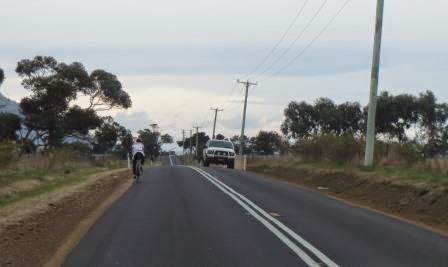
Looks
colourful with all the autumn colours as we head into Richmond.

Over
the historic bridge.

At
the intersection I found the site of the old Barracks now holiday
accommodation.

Then
we turned to head towards Campania. Passed a sign advertising Unicorn Poo – we
have seen all types for sale but that one is a first. There is an advert on TV
for Holden Colorados where he is towing a van (with ease) then he comes up
behind another caravaner and he says “bloody caravaners”, well we say “bloody
cyclists”!!
Up
through the Coal River Valley passed vineyards, orchards and pastures. This
area is one of Tasmania’s most productive and diverse agricultural regions. It
reflects an earlier era when, during the 1820s, the region provided Sydney with
essential food supplies. I am definitely enjoy the rural views rather than a
city view. The sky is clearing but there is a low smoke haze which doesn’t make
for clear, clean scenic photos. Into Campania which was developed around the
railway station opened in 1876, on land that was previously part of the
Campania Estate, owned by James Brock. We stopped for a cuppa at the
Bicentennial Mill Park which has a historic steam, flour mill (c1884). Looks
like it is used by the local school now.


Stephen
Walker and family donated this bronze sculpture to celebrate the Bicentenary,
it is titled “To School”.

This
sculpture “Harvest” celebrates Mr Arthur Plummer’s 100th birthday
and acknowledges pioneering families for their determination and achievements in
our region (12th Sept,1999).

Steve
trying to work off the Fudgy Wudgy cookies!!

Here’s
the lovely Gingerbread Spice Pumpkin Cake I made.

Following
the Coal River down in the gully then a climb uphill to 220m.

Looking
back down the valley.

Craigbourne
Dam has great fishing.

Nice
and green here.

Stopped
at Colebrook (280m), which used to be called Jerusalem, to check out the
convict Probation Station (c1841). Chatted with the people at the Info Centre.
This is the Police Station (on left) and policemen’s quarters on the right.

The
Probation Station is now privately owned so just took a couple of photos from
the outside. It is now surrounded with a hedge where in the old days it was
surrounded by a big stone wall to keep the convicts confined. Around the back
there are only the foundation remains of the actual convict cells.

An
old steam engine was in the back yard.

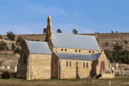
Walked
up the road to St Patrick’s Catholic Church which was designed by Augustus
Welby Northmore Pugin in 1843 and constructed in 1855-57. He is considered the
‘father’ of the Gothic Revival movement in England. Pugin also designed the
British Houses of Parliament, including the famous Big Ben. The church is
currently being restored by the Pugin Foundation.

Climbing
again to 480m – looking back to Colebrook.

Lots
of sheep here then a melaleuca tree farm. Spotted someone on the hill – there
are heaps of these metal silhouettes along the way.

Nearly
missed this one – must be a bushranger.

Into
Oatlands and parked the van by Lake Dulverton.
Nice spot though there is swan and duck poo everywhere.

Made
some lunch then headed off to explore Oatlands. Info board about the Lake. It
was a natural lagoon then they put in a bund wall to keep more water in it for
drinking water. Unfortunately the birds liked it more and polluted the water.
Interesting reading – it even dried up much that they could land ultralights on
it.

On
the other bank you can see where they got the sandstone from to use in the
local buildings.


Great
topiary trees which have been a local tradition in the area since the 1960s.

Walked
up to the ‘high’ camping area which used to be the Webster Ltd cattle yards,
between 1926 and 1988.


Through
the gates into the Callington Mill area to more yards and old machinery.

Great
playground tree house with animal carvings.


The
old cap from the windmill is up for sale. It was built in the late 1980s. The
interior hardwood that forms the curvature of the cap was steamed on site.
Fibreglass was then put over the top. It was replaced early 2000s. The sign
said that it had to be removed by 31st March, 2015 but obviously no
one has bought it as it is still there.

We
were entering the complex from the rear. Steve looks so small against the
windmill. Took a video of it going around and the sound of the mill working.

Found
the Info Board at the entrance. The mill, called a Tower Mill, is the only
remaining wind powered mill in the Southern Hemisphere. It is 15.4 metres tall
with the cap and fantail adding another 6 metres. The freestone walls, quarried
from the lake shores, are almost a metre thick at the base.

Watched
the worker loading up the bags with flour.


The
Miller’s Cottage (c1860) was open. A wind-driven mill required constant
attention so the miller always lived close by. One of the millers was William
Thomas who was a former convict who became one of the first millers to operate
Callington Mill and presumably to live in the cottage. He is also said to have
been the first settler in the area to grow potatoes successfully.

A
picture showing how the mill works.

The
Parterre Gardens, established around 2000 by a community group, with the
Stables, bakery and cottages in the background.


Looking
up at the timber and canvas blades going around.

The
72 foot Mill Well (c1846) was associated with the steam driven mill, which
required a reliable supply of water.


At the entrance looking at the Millowner’s
House (left), stables (middle) and granary (right).

Steve
was in the Granary (c1838) checking out all the information. The grain is stored
here before milling until 1846, which it was adapted to accommodate a steam
mill.

John
Vincent wasn’t a very nice man but he had vision and was willing to try
anything. The mill was in operation through different owners from 1837 to 1893.
After a fire there wasn’t much left and the base of the tower was turned into a
water tower.


Then
in the 1980s restoration work started and 30 years later it reopened as a
working flour mill costing 2.6 million dollars. Funded by the local and federal
governments and the local council who owns the historic precinct.

How
the mill and the stones work.


Info
about grains and bread.


Some
more of the buildings – an outbuilding (c1837) was probably a piggery.

The
Stables (1837). With a loft above and a cart house at rear, these stables
accommodated the horses used in transport to and from the mill. After the
installation of the steam mill a constant supply of wood was needed and the
teams of horses must have been bush.


Steve
doing a horse impression of what they do while they eat!!

The
Millowner’s House is the information centre and café. The house was built in
1837 as a four roomed cottage then extended about 1848 and again around 1910. The
flour they mill here is for sale and is used by lots of bakeries throughout Tasmania.

Dry
stone walls surround most of the area. These walls were erected in 2007 by a
lady.


One
of two mill cottages (c1838). In the back yard you can see the natural
sandstone which is being created into a water feature.


Out
of the precinct onto High Street. We feel we are in an old English town. So
wonderful to see so many of the old homes still standing and being lovingly
restored. Most have a plaque explaining the life of the building. This town as
the most stone Georgian buildings in it than any other Australian town. Nearly
all of them have been continuously occupied for 100 to 150 years. Oatlands was
developed as a military base for the management of convicts because of its
central location between Hobart and Launceston.

The
one was part of the Mill precinct and was once the bakery. John Vincent Junior
bought the mill from his father in 1840 but he was not a miller; he was a baker
by profession. He added the steam mill and this bakery to the mill complex,
which he operated from this building between 1840 and 1853.


The
topiary artist has been at work again.

Would
be lovely scene when the trees have leaves or at the beginning of autumn and a
finer day. Bit of a cold day to be wandering about but it is bearable.

The
old Stables area of the Mill precinct (c1832).


Great
artwork. The chicks in the nest are spanners.

Sheep
in a boat.

Some
of the houses have wonderful gardens.

One
with potential!!

A
couple of grand buildings are part of the Military Precinct, between 1827 and
1851. Will do the rest of the precinct tomorrow.


The
large building was the Town Hall (1881).

Commandant’s
dwelling (1828) is set back and half obscured by another building.


The
Post Office (1886) has been modernised at the front but the back is still
original.


Crossed
the road and headed back down the other side of High Street. Lovely cottage set
down from the road (1832) was home of the Police Chief Constable.


Some
more topiary creations.


This
building has housed different banks constantly for over 100 years but closed
its doors last year.


The
Kentish Hotel, a building was on this site as early as 1832, and in 1834,
Joseph McEwan was granted a licence for the then called “Inverary Castle”, but
from 1843 it was known as the Kentish Hotel. There was a brewery at the rear
and also a blacksmith and wheelwright’s shop, but now all that remains is the
“old loo”. As each brew was made, local legend has it that a keg was placed
outside the hotel, a mug affixed and customers could sample it and if it was to
their liking, enter and imbibe at their pleasure.

The
Blacksmith’s Cottage (c1829) became a boarding house. Interesting info about
one of the lodgers in this house who was executed at Oatlands Gaol.


Stopped
at Elm Cottage (c1837) as the resident cat wanted a scratch.


A
tiny flower coming out on the tree.

Raffah
(c1850).


Oatlands
Coach House (1855).


The
convict stone cottage behind the Coach House (1829).

Oatlands
Lodge (c1830s).


The
shop owner bribed the men working on the road to put a curve in the road so
that people would slow down and see her shop.

An
old wool press with the wire frame used to shape the topiary trees showing a
sheep being shorn. Unfortunately the bush has died so there is only the frame.


The
only co-joined cottages erected in Oatlands (1835).


There
is a crane and its nest on top of the chimney. A few other birds think it is a
good nest too.


Cantwell’s
Store (c1857) and Cottage (c1840).


Smith’s
house and bootmaker’s shop – This house is a fine example of a colonial
weatherboard dwelling and was erected by 1846.

The
bootmaker’s shop belonged to Bob Geary and was built in 1920.


A
brewery, the third in town, was at the rear. The unique row of cottages at the
northern end of township is where settlement first started in the late 1820s.
The stone was quarried near the footpath at the opposite side of the road and
from the foreshore of the lake.

Unfortunately,
a lot of the face of the foreshore was filled in in the early 1970s during a
beautification program. The other local quarry belonged to the Fish family and
is situated to the south east of the town. Originally the stone was blasted in
huge pieces by drilling approximately sixteen holes twenty feet deep and each
hole was loaded with seven pounds of powder and one plug of gelignite and fired
simultaneously. This would dislodge a section of approximately seven hundred
tons. Stone from Oatlands was used for the cloister section St David’s
Cathedral, Hobart.
Dulverston St to Ross Street info - Historically unique, as a group, these cottages are built on land allocated to a Thomas Brown, prior to 1819. The land was sold and split into smaller allotments. The brick cottage was built in 1844 and has a brewery behind it. James Parker, a stonemason, bought it plus the remaining land and it is believed that he built more cottages here from freestone and brick. He died in 1854. Locally this area of town used to be referred to as Wapping.
Dulverston St to Ross Street info - Historically unique, as a group, these cottages are built on land allocated to a Thomas Brown, prior to 1819. The land was sold and split into smaller allotments. The brick cottage was built in 1844 and has a brewery behind it. James Parker, a stonemason, bought it plus the remaining land and it is believed that he built more cottages here from freestone and brick. He died in 1854. Locally this area of town used to be referred to as Wapping.


Another
convict built cottage (1853).


At
the end of the Lake and some of the sandstone rocks.

Dulverton
Dam info and the dam walls.


The
dam has more walls dividing it too.

Beautiful
big trees line the lake.

Into
the van as we are freezing. So heater on. TV for Steve, blog for me. Getting
dark so early it makes it feels so late – such a change from when we first came
and the sun was still bright at 9pm!!
Rang
Mum and Dad for a chat to tell them about playing with the snow on Mt
Wellington.
What an amazing tour you have done of one of the prettiest places in Tasmania. Our 2nd great grandfather owned the Callington Mill, he bought it from John Vincent. We are having a Jillett/Bradshaw Reunion in October, and one day is devoted to Oatlands. You have provided a lot of information about the town, well done and thank you. Our family links to the town are huge. Regards Kris Herron
ReplyDelete