Woke
up at 6.45 and saw the colour in the sky so threw on a jumper and went out to
the point to take a photo of the sunrise. It was 13.4 degrees inside but a lot
colder out!! Such a beautiful morning – clear sky, no wind, just perfect. So
hard to imagine after all the wind and rain last night. A car had pulled up
last night and now the girls came out to join me. They are from Germany and
just arrived last night in Hobart – quick trip around Tassie.

The
moon was still up in the west.
.JPG)
.JPG)
The
sun was just starting to come up.
.JPG)
.JPG)
.JPG)
A
couple of dolphins swam by.

I
was chatting to the girls and nearly missed the sun rising!!
.JPG)
.JPG)
.JPG)
.JPG)
Back
in the van to warm up – little rainbows on the ceiling from my crystal.

Got
Steve out of bed – he saw the dolphins too as they went further along the
beach. Packed up and headed into Coles Bay to do the walk to Wineglass Bay and
then along Hazard Beach – 5 hour hike. Packed our lunch and a glass of wine to have
a Wineglass Bay!!
Stopped
first at the pier to get a better, blue sky photo of The Hazards. Found out
they were named after an American whaler, Albert “Black” Hazard who was captain
of a whaling ship working in the area in the 1820s.
.JPG)
.JPG)
Coles
Bay is nice and calm.

Made
a cuppa while we in the carpark and checked out the information.
.JPG)
.JPG)
Then
off we set for our hike. It is a glorious day.

The
rocks are amazing.

Up
we climbed – stopped to take some photos – and a breather. Looking over Great
Oyster Bay towards Swansea. A band of cloud hanging there that might come our
way.
.JPG)
.JPG)
.JPG)
.JPG)
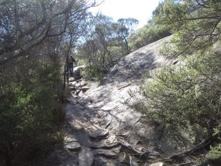
Good
walking surface.

Then
we hit the steps!!

Hope
that rock stays there.

At
Coles Bay Lookout. A lovely young lady offered to take our photo.

Then
I took another one.

Steve
got gobbled up by a rock.

More
steps – we think there about 300!!

We
are walking up between Mt Amos and Mt Mayson. Great rock formations on Mt Amos.

At
the top of the saddle between the mountains so I had a rest on this great
chair. ‘Saddle Seat’ was designed and constructed by two School of Architecture
students in 2000.
.JPG)
.JPG)
Looking
above at Mt Amos and ‘Turtle Rock’ (well that’s what we are calling it).
.JPG)
.JPG)
The
saddle area.
.JPG)
.JPG)
Another
5 min walk up to the Lookout before the walk down the mountain into Wineglass
Bay. Love taking photos of the rocks.
.JPG)
.JPG)
Some
old wheel or something is imbedded in the pathway but no info about it.

Climbing
up to the lookout – another shot of the rocks on one edge of Mt Mayson.

Then
we see the most spectacular view of Wineglass Bay. I climbed up on a big
boulder to get a higher view. There is another walk to the summit of Mt Amos,
that we are under, but it is not a safe one, big boulders to climb over etc and
with this view why would you bother. Took a photo on my phone and posted it on
Facebook (I hope)!! Haven’t done that before so hope it works.

We
are so lucky with the weather since the forecast was for more rain. The wind is
quite strong though and it is picking up so hope it doesn’t bring any rain for
a while yet. Looking over the Isthmus and the Hazards Lagoon to Great Oyster
Bay on far right. Mt Graham (579m) on left and Mt Freycinet (620m) on right.

Then
around to the back of Mt Mayson.

Zoomed
in on the waves crashing in Great Oyster Bay as the wind is coming from the
west.

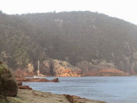
Zoomed
in on a yacht in the bay – looks like paradise. Bet the water isn’t warm
though!!

The
beach is so white and all rippled. Will walk down and have lunch there.

There
were a heap of people at the lookout and we all took photos for each other.

She
climbed up higher for another photo of us.

After
chatting with four kiwis from Nelson and a few other people we headed down
towards the bay. Steve was looking back up to the lookout.

.JPG)
.JPG)
Down
we go.

Another
shot of the rocks.

Going
down, chatted with two girls as they passed us. One from India the other from
Germany.

Nearly
to the beach where the turn off is to the Isthmus track that we will take
around to Hazards Beach later. There is a longer overnight hike to Cook’s Beach
and around the Peninsula.
.JPG)
.JPG)
Down
onto the beach. It feels like a tropical paradise, could just strip off and
dive in, ha ha. The water is freezing.
.JPG)
.JPG)
Great
photo of Steve and then us.
.JPG)
.JPG)
Looking
up at Mt Graham.

Back
up to Mt Dove (the next one over). There is another bay around the rocks called
Hawkesnest Cove and the wind is howling through there whipping up the water. We
are protected here but you can hear the wind in the trees above us.

Sat
down by the water for our lunch.

Even
brought the wineglass for the wine!! I read in one article that it was thought
the name came from the colour of the water when the whaling was done here –
blood red like red wine.

Lots
of lichen on the rocks here too – better colours than the ones we saw at the
Bay of Fires.

Climbed
up on the rocks for another few photos of the beach and the bay.
.JPG)
.JPG)
.JPG)
.JPG)
Walked
along the beach for a while – only found one nice shell, hardly any on the
beach. Mt Amos on left and Mt Dove on right.

Out
Wineglass Bay to Thouin Bay.

Then
to the other end of the beach where the Peninsula track heads off from.
.JPG)
.JPG)
Looking
up at Mt Mayson again.

Around
to the other cove.

Back
on the track again – the Isthmus Track will take us across to the other side of
the peninsula. The vegetation changes a lot.
.JPG)
.JPG)
Past
the Hazards Lagoon.
.JPG)
.JPG)
.JPG)
.JPG)
Boardwalks
and bush.
.JPG)
.JPG)
The
end of the lagoon.

Looking
back to the southern side of Mt Mayson.

Up
the sand dune.

Another
lagoon.

Over
the top then down onto Hazards Beach.

Refuge
Island and Promise Rock are in Promise Bay. The wind is so strong, it is
whipping the sand up as we head off. Looks like some rain is coming our way.

Another
2.5hours (7km) back to the carpark from here or the same in the southern
direction if you are doing the overnight hike.

We
chose the one back to the carpark!! Looking towards Fleurieu Point.

There
are oyster shells everywhere, not sure if they are midden piles or just washed
up onto the shore as it is called Great Oyster Bay!!

A
rainbow appears over Promise Rock.

Made
it to the end of Hazards Beach.
.JPG)
.JPG)
.JPG)
.JPG)
Back
up through the trees.


Higher
up on the cliffs for a view over Refuge Island and Promise Rock and my rainbow.

Lots
of lovely secluded bays along the way.

Up and down and through the changing vegetation till we look over Great Oyster Bay to Swanwick and Hazards View (north of Coles Bay).

Up and down and through the changing vegetation till we look over Great Oyster Bay to Swanwick and Hazards View (north of Coles Bay).
.JPG)
.JPG)
.JPG)
.JPG)
Looking
back over the bay towards Swansea.

Into
big boulder area. Passed a couple with their huge packs heading off for the
overnight camp spots.
The
rocks on Mt Mayson came back into view.
.JPG)
.JPG)
.JPG)
Kept
trudging along, sometimes away from the water and others on the cliffs above
the water.


Further
around Picnic Island come into view.
.JPG)
.JPG)
Some
more rocks to negotiate.
.JPG)
.JPG)
Slowly
getting closer.
.JPG)
.JPG)
Looking
back into the bay where the boats are moored. A lot choppier now.

Great
view across the bay with the sun on it.

Steve
thought we were nearly there but it was a different pile of rocks!! Another
valley to cross yet.

More
rocks.

.JPG)
.JPG)
.JPG)
Well
worn path.

At
last we see the front of The Hazards again.

But
still a way to go yet.
.JPG)
.JPG)
The
big black cloud is following us.

The
grass trees are all dying from a root rot disease.

Thought
I should get a flower photo!

We
kept going.
.JPG)
.JPG)
.JPG)
.JPG)
Nearly
at the turnoff back to the carpark and the phone rang – it was Jon. Having a
laugh about us coming home – did we need money and Dad wanted his job back!!
Not likely though Steve said he might consider it after the walk he has done
today!! The black cloud has caught us so we said good bye and walked quickly
back to the truck as the rain started to fall.
Sat
in the truck till the downpour passed then headed off to Cape Tourville where
the lighthouse is. I made a cuppa then another scud of rain came through so we
sat in the truck – The wind is freezing too. After it passed we put on our
raincoats and headed off – only a short 20 minute walk around the point. A
rainbow came out over the lighthouse.

How
the day and clothing changes in Tasmania!!

Info
sign along the boardwalk about the view.
.JPG)
.JPG)
.JPG)
.JPG)
.JPG)
Zoomed
in on Wineglass Bay – the yacht is still there.

There
used to be a lighthouse on the small rock – Lemon Rock. The other bit is called
Cape Forestier.

Steve
noticed some caves in the granite on the waterline.
.JPG)
.JPG)
What’s
on the horizon – a big black cloud that just dumped its rain on us!! On the
boardwalk they marked the length of difference sea creatures, dolphins, whales
etc.
.JPG)
.JPG)
Further
around the point another great shot of Thouin Bay and the Wineglass Bay
surrounds.

Climbed
up the steps to the lighthouse – constructed in 1971.
.JPG)
.JPG)
.JPG)
A
shadow has fallen over the bay making it dark and mysterious.

A
rainbow appears in the rain out at sea.

Further
out onto the point was another lookout and information.

Looking
north towards Friendly Beaches and our van.
.JPG)
.JPG)
On
other side of lookout was another info board.

The
rocky islands are called ‘The Nuggets’ and 1000 birds nest there each year.

Looking
across the Tasman Sea, if we sailed due east for about 1000 kilometres you
would make landfall on the central west coast of the South Island of New
Zealand. Follow the rainbow!!

Another
board about the history.

In
my pocket I found the shell from Wineglass Bay and a piece of oyster shell I
picked up from Hazards Beach, to add to our collection.

Headed
back then stopped off at Sleepy Bay. Even though the legs were tired we headed
down the steps. What a beautiful little bay. Someone is enjoying it.


Info
about the change water temperature. There was a note down the bottom about
another beach which we said we won’t bother with. Decided to follow the track
to go down to Sleepy Bay though.

Great
view across to Lemon Rock.

Turned
out the lookout was all there was of Sleepy Bay and we had just down the walk
to Little Gravelley Beach.

Just
before we made the beach the rain came down so we hid under a tree canopy as we
didn’t bring the raincoats – we were only doing a 10 min walk – or so we
thought!

The
name fits because all the granite rocks made gravelley sand. Some people were
fishing off the rocks and have just caught one but to the kids’ delight.

Looking
back to Sleepy Bay.
The
boulders have been eroded into unusual shapes.

Another
lovely rainbow.

Looking
back up towards Mt Parsons, the other end of The Hazards.

Back
up the track to the lookout, then back up more stairs.
.JPG)
.JPG)

Exhausted
but glad to have had such a magnificent day for our walks. Headed back via the
jetty in case the penguin was back. He wasn’t and the bay was very choppy now I
wouldn’t have seen him. Also David Geck had rung but no answer when we rang
back.
Back
to the van, it hadn’t been blown away, though the solar panels had skidded
along in the dirt.
At
6pm I hoped in the truck to try David again. He and Amanda were out so I
chatted with Ella. Then I rang Dan for a chat – looking forward to seeing him
again. As I looked out the window there was a big black cloud on one side of
the windscreen and clear sky and stars on the other, then the rain came down!!
Back
in the van where it was 17 degrees but feeling a lot colder as the outside temp
had dropped to 10 degrees with the wind. Warmed up with beautiful pumpkin soup
and our fish then a hot shower with the heater in the doorway of the ensuite to
keep me warm while I dress!!
At
8pm the sky is clear and it will be a cold night. Looking forward to getting
the diesel heater now.
No comments:
Post a Comment