Good
night sleep after our big day yesterday. After morning tea with Joc and John we
headed south to check out the Port Nepean National Park that we missed last
time. Looks like it is going to be a lovely day as we head into Frankston.

Turned
off to check out The Briars Historic Park. In the Info Centre the lady told us
about the estate. It was first owned by Captain Reid and called Checkingurk. The
Balcombe family were living at their family property in St Helena, called The
Briars. It was where Napoleon was banished too and they were given lots of
gifts from Napoleon. When the Balcombes came here they renamed the property to The
Briars also. Very interesting.


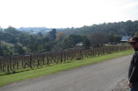
They
had a vineyard here but the wine was no good so it was known at Balcombe
Vinegar.

The
homestead and other buildings were bequeathed to the National Trust and the
land was handed back to the Council to preserve as a Reserve. There are a few
walks. We chose to walk along the original driveway up to the homestead. It was
bounded by English Elms, Oaks and Stones Pines.


Some
lovely old trees.

Unfortunately
there was no volunteer today for the walk through the house so we just wandered
around the verandah.

Peered
in the window.

Great
view over the orchard and vineyards. They have been replacing the old apple and
pear trees.

Around
the back was the vegie garden where the volunteers are growing the types of
things that would have been grown in it originally.

Found
some comfrey – mum’s favourite cream.

Further
down was the pig pen with Berkshire Pigs which are a rare breed and are listed
as ‘vulnerable’ by the Rare Breeds Trust. These pigs were common in pioneer’s
home gardens, orchards and small holdings in Victoria and were introduced into
Australia with the First Fleet in 1787. They are a hardy breed, best suited to
free range grazing. After 1950, factory farming began to dominate food
production in Australia and slowly, Berkshire pigs fell out of favour with
small farmers. The Briars is helping to conserve our heritage by incorporating
these pigs into the Briars Community Farm.

In
the chook pen were Cochin Chickens – another rare breed from the 1850’s, also
common in pioneer’s home gardens. They were a dual purpose breed - for eggs and
meat. They are hardy, long lived and docile. Before factory farming became
dominant in the 1970’s, there were many dual purpose poultry breeds that suited
the home gardener. Many of these varieties are now considered rare or extinct.


Wandered
around reading the information boards. The South Wing.


The
Hutch.


The
dairy and laundry.


The
barn area is now a fancy restaurant called ‘Josephine’s’. Lots of wedding
receptions etc are held here.

The
apple store.


Another
view of the homestead and the hatch.

In
the barn were a few old sulkies, wagons and an old Furphy water cart.


A
lot more vines have been put in.
Back
on the road heading south was stopped at Rosebud for lunch.Texted Roz and Janet
to let them know we are here. Will meet up with them tomorrow. Ordered a
Terriaki Chicken pizza which had a bit of Tabasco. I said hold the Tabasco but
I think he heard ‘double the Tabasco’ because it was very hot!! Sat out on the
‘green’ where the council was trying to save the sand from being washed away
with rock walls etc. The magpies joined us for lunch and were very well
behaved. Amazingly the seagulls just waited patiently on the ground.


Got
down to Point Nepean National Park about 3pm so drove as far down as we could.
Stopped at the Gunners Cottage.


Picked
up the park notes pamphlet and headed off to find the Fort. Didn’t stop at the
cemetery as we are running out of time then realised we were taking the long
way down via Observatory Point. This is the site of the cattle jetty, built in
1879, where they unloaded all the animals for the Quarantine Station. One of
the ferries heads back to Portsea from Queenscliff.


Looking
back to Portsea then down to the entrance of Port Phillip Bay.


Zoomed
in on the lighthouse at Point Lonsdale.

Headed
back along Coles Track following the telephone line poles. Nice easy walk.


Back
onto the main road where a bus goes - $10 each to go to the Fort. Past the turn off to walk up to Cheviot Hill
where there is a gun emplacement near the top.


Looking
across Bass Strait then to the other side of the point to Nepean Bay and Port
Phillip Bay.


Along
the way was the Harold Holt Memorial. He disappeared from Cheviot Beach, below
us, while swimming in rough weather on 17th December, 1967.


Lovely
view and no rough seas today.


Further
around we see another gun emplacement facing out to Bass Strait.


Zoomed
back over the hill to Cheviot Hill gun emplacement.


Looking
back to the other gun emplacement we saw before on the ridge then along the
beach to the next gun emplacement on the next ridge.


That
one was below Fort Pearce which is buried under sand on the top of the hill.

Amazing
how they built all this in the 1880’s.


Pearce
Barracks.


Narrow
strip of land as we head down to Fort Nepean.

A
boat coming in the entrance through The Rip.

Walked
up the boardwalk to the top of the other gun emplacement at Fort Pearce.


Looking
back to the other gun emplacement and the one below Fort Pearce.


Along
the beach on each side they built walls. Bayside then ocean side. The big waves
have been knocking the capping off the wall.


Arrived
at Fort Nepean. The tram tracks they used to move the ammunition etc around
with.

Looking
back up the peninsula from the Upper Barracks area. The soldiers living here
slept in blocks of four men on bunk beds made of iron with straw mattresses,
separated by a decency board.


Headed
into one of the tunnels – amazing and fascinating.


In
the bomb proof room there was an audio presentation and this board.


There
were no electric lights here until World War 2. Before this, candles and then
kerosene lamps were housed in special glazed and sealed recesses to provide
light in the tunnels and magazines. The naked flame lanterns had to be
completely isolated from gunpowder dust to prevent explosive disasters!

Up
the stairs to a viewing hole but the sand has built up so we couldn’t see much
of the sea.


Down
another tunnel to the site of the Disappearing Gun Emplacement 1.


Upstairs
to the parade ground.


These
are the two big guns that fired the first shot in WW1 and the other in WW2.


The
Battery Observation Post.


What’s
coming Captain Steve.

Load
up the guns!!

A
rangefinder.


As
the sun is setting it is making unusual colours in the sky.


Across
the way there was another tunnel and another hidden gun emplacement. There is
so much here we need more time. Might have to come back again.


The
shell lift – looking up the shaft too.


Ammunitions
Room.


One
of the big gun emplacements.


Great
view over the entrance to Point Lonsdale lighthouse.


The
Magazine is buried under the gun emplacement.


The
site of the other big gun emplacement which fired the first shot of World War 1
in 1914.


This
photo was taken here at Gun Emplacement 6 (1914) as a record of the first shot
fired in the entire British Empire in World War 1.

Steve
pointed out how they got fresh air through this hole which was protected
outside.


We
are running out of time as the sun starts setting.

Headed
down the steps to the Engine Room. First was another gun emplacement that was
changed to the searchlight station in 1910.


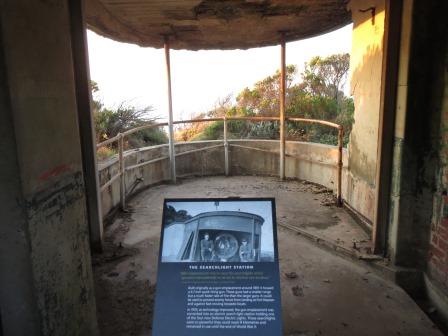
The
top of the Engine Room was covered in tar. It still smelt of diesel.


Down
the worn stairs to the Lower Engine Room.


Poked
the camera through a grill and got a picture using the flash of another tunnel.

Outside
the sun was making the peninsula glow orange.


The
latrines for the engineers just emptied straight into the bay!!

Their
barracks were located at the base of the stairs. Obviously the area has been
washed away as there are new rocks here protecting the banks.

Now
for a quick jog up the stairs!! Should have counted how many there were!

The
old jetty.

Made
it to the top, puffing.


Into
another gun emplacement site and more tunnels (now covered). During the war the
guns were manned 24 hours a day using a three watch rotation system.


A
shell.


Muzzle
loading guns.

Hooks.

Another
information board where the bus stops.


The
sun is about to set – spectacular.


Heading
back along the road looking up the peninsula.

The
concrete wall protecting the sand on the Bass Strait side.

Back
to Fort Pearce for a last shot of the sunset.

Quick
stop at Eagles Nest info.


Good
signs to deter people from going off the beaten track!!

Back
to the truck in the dark. As we head out the gate automatically opens and we
have to drive over spikes that don’t affect us as long as we are going out.
They must have had problems with people trying to sneak in to put this into
place.

It
is only 5.45 but dark as we head back to Mt Eliza. Rang John to let them know
we were heading back. Lovely dinner of swordfish and vegetables followed by
plum pudding and icecream.
No comments:
Post a Comment