Frost
this morning but we weren’t freezing as it is 5.9 degrees at 6.30am in the van.

Mist
lifting off the river and covering George Town. I noticed that these towns have
Town as a separate word rather than Qld’s Georgetown version – Campbell Town,
Elizabeth Town etc.


After
we had warmed up we headed off to check out Greens Beach. There is no wind
today so it is actually a lovely day as long as you are standing in the sun!!
Read the info board near the beach about the history and environmental issues
of the area.


Walked
down onto the beach which was lovely except the piles of seaweed. Chatted with
a couple from Gravelly Beach.


They
said the black swans have only just started coming to this area.

Looking
across to the lighthouse at Low Head.

Cute
beach huts line the beach.

Found
the one and only shell on the beach.

Walked
back up the street and stopped at the shop. Kerry’s friend Sharon owns it and
she and her husband Neville were outside so we stopped for a chat. They said
that the frost is quite rare to be this close to the water.

Neville
said to go up the hill for a great look over the area. He was right – looking
across Port Dalrymple with Hebe Reef in the middle, to Low Head Lighthouse with
Tenth Island in the distance.

Then
looking down on Greens Beach. Certainly is a beautiful day.

This
gardener has turned the local shrubs into cute shapes.

Drove
out to West Head in the Narawntapu National Park. Walked down the narrow valley
to the beach which was very rocky.

Looking
over Badger Beach then round to Badger Head.


Looking
up to where we are going to walk out to the lookout.

The
Black Cockatoos were making a racket as we headed back up the path.

Out
onto the lookout – great view to the west.


Zoomed
in on the coastline further west which would be the Devonport area.
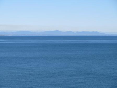
West
Head.

Drove
back then stopped off at Pebbly Beach. Very smelly seaweed here and yes lots of
pebbles.


Looking
back to the lighthouse.

Headed
back through Kelso where all the houses have lovely river side views and green
esplanade.


Went
back to the van for lunch then headed off across Batman Bridge again to head up
the East Tamar Highway through George Town to Low Head. Stopped at the
lighthouse. Found a plaque about a yacht race in 1907.

Lots
of information to read.


The
Low Head Lighthouse, built in 1888. The original one was built in 1833.


The
walls are very thick.

Great
view from here too, back down the Tamar River then back up to the mouth-Port
Dalrymple.


Zoomed
in on Hebe Reef.

The
old Foghorn housed in this shed, has been rebuilt and still sounds at midday on
Sundays.


The
Foghorn.

View
around to East Beach to the east. Great day for a boat ride, it is so calm.

The
point is also a nesting area for the Fairy Penguins.

A
number of other buildings were later added to the lightstation complex. These
include a new Head Keeper’s Quarters built in 1890 and the Assistant Keeper’s
Quarters, built in 1916. The Head Keeper’s Quarters is now used for holiday
rental.


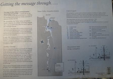
More
information about the lighthouse and communication methods.


A
replica semaphore mast.

More
info about Dotterel Point where the penguin rookery is located.

Lots
of historic homes along this road.

This
one seemed to be lots of small cottages all joined together.


‘Braeside’
then ‘Kuranui’ built in 1888.

This
is ‘Gunns Castle’ which was a Gentlemen’s Retreat built in 1929.

Lovely
sheltered boat ramp. Apparently the weather can be horrendous, hard to believe
when we are having such a lovely day.

Drove
in the entrance built to commemorate the 150th anniversary of the
oldest existing building and the 180th year of continuous manning of
the Low Head Pilot Station in 1985.

Very
neat and tidy. The main buildings on the left are now home to the Maritime
Museum. It was built in 1835 using convict labour to house four pilots and
their families.


Went
for a walk around reading all the information. This ship’s bell is a
replacement one as the original that was there from prior to 1900. It was used
to rouse the crews and could be heard throughout the whole pilot station.

It
is beside the repositioned octagonal Chart Room which used to sit closer to the
jetty. It was the original Watch House (shown here in the 1880s – the tall
building on the left was the Sea Reach Lead Light). Its three windows were
aligned with Barrel Rock, the Lighthouse and the Lead Light, evidence that Low
Head’s early sight lines were used over a long period.

Unfortunately
the signs haven’t been maintained but this shows the sight lines from where the
octagonal room was.

Matthew
Flinders memorial on the site of the octagonal room commemorating the discovery
of Port Dalrymple on November 3rd, 1798.

Great
info about piloting in the area and the convict pilot that made off with a
ship.


One of the semaphore masts.


Looking
across to the two Lead Lights.

The
original jetty that the pilot walked out onto to board his row boat to go out
to the ships.

PLA
Wooden Marker Buoy was used at Hebe Reef. Constructed of Huon Pine and used
from 1835 to 1960 to mark the channel and other hazards.

This
capstan was salvaged from the four mast Barque ‘Farsund’ which ran aground and
became a wreck at Vansittart Shoals, Flinders Island on March 10th,
1912 and placed here in 1913 to haul out buoys and boats. Around the base it
says ‘Stockton on Tees’, probably where it was made in England.

The
other side of the Pilot Station buildings.

Lovely
little church built in 1877.

Information
hut showing a map of the Pilot Station buildings and descriptions. Looking over
the area.


More
information and Pilots Bay.


Down
the road we turned off to She Oak Point to check out one of the Lead Lights.
There was a plaque dedicated in 1974 to commemorate the location of the first
signal mast at Low Head by Lieutenant-Colonel William Paterson in 1804 and the
building of the Low Head Lighthouse in 1833.

Very
rocky beach.

The
next Lead Light.

Into
George Town to check out the Water Tower Mural we saw on a sign as we drove
through. Unfortunately they only give you one sign off the main road then it is
‘find it yourself’. Shouldn’t be too hard to find a big water tower but it was
as it was over a hill!! It was in Arnold Street (Dad’s mother’s maiden name). Great
murals though, which were completed in 1985.


Drove
down to York Cove – picturesque.

Looking
across the Tamar River to where our van is.


Then
around to Windmill Point. In 2013 Eddie Freeman transformed some old Macrocarpa
Pine Trees on the site of the old ‘Cable House’ which was built here in 1892.


It
depicts a mother whale and her baby, some penguins and the cablemen hauling of
the submarine telegraph cable ashore.

The
next tree had three men but no information.

On
the point is a memorial to Lieut. Colonel William Paterson, NSW Corps, who
landed near here from HMS Buffalo on 11th Nov, 1804 and took
possession of the northern territory of Van Diemen’s Land in the name of his
Britannic Majesty King George III.

Another
info board needing some tidying up. George Town was originally called Outer
Cove. It was competing with Launceston as the northern capital. Bit like Cairns
v Townsville.

Through
George Town and up to Mt George. Steep climb which some crazy people were
walking. A flagmast at the top with lots of other towers. The mast was donated
in 2001 and was part of the recommissioned semaphore communication system that
extends throughout the Tamar Valley. The flags were Marryatt’s Code flags.


There
was also a Semaphore Mast and information about sending messages.

This
lookout was placed here in the 1930s when the road up Mt George was
constructed. This project was part of an unemployment scheme introduced during
the depression years. Obviously there were no trees here then as you can’t see
anything from it now.

This
lookout though has fantastic views (though a few trees could be pruned!!) The
Lions Club installed it in 1993.

Great
info boards showing the area and the big companies working here.


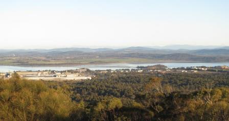


Then
around from Clarence Point to the mouth. Read on a brochure that George Town is
now Australia’s oldest town because Sydney (est 1798) and Hobart (est 1803) are
both now cities, not towns!!


Zoomed
in on Batman Bridge.

Then
the headframe at Beaconsfield.
Now
we know where all the logging trucks are going – to make medium density fibre
board.

Zoomed
in on Garden Island where we are camped.

Then
Low Head Lighthouse.

Back
down to the highway, looking up at Mt George and the towers we were just at.


Passed
the huge power station at Bell Bay that is run on coal rather than hydro. Lots
of powerlines heading south.

Lots
of wineries and tree farms, both eucalypt and pines near Sidmouth and Kayena.

The
sun is setting.

Drove
out onto the wall for a photo but the sun had already gone down (5pm).

The
moon is full and rising over George Town.

Put
the heater on – it is 4.5 degrees at 6.30pm.
At
8pm it is only 3.5 degrees – so glad we spent the money on the heater!!
No comments:
Post a Comment