Overcast
morning with a light breeze but the sun was peeking out at 9.30am as we headed
off. Put leggings on though as it is a bit nippy and we are going walking. A
big ship zipped past us.

Stopped
at the ABTAS Seafoods place that we pass as we drive into Garden Island area. I
asked the chap working there about it. They grow the abalone in the concrete
tanks and sell them directly to the mainland for restaurants etc. The bottom of
the tank is covered with half besser blocks.


Back
down the road towards Beaconsfield we stopped to check out a monument I saw. It
was the Anderson Creek Monument which marks the discovery of the creek by
Ensign Robert Anderson in 1804, where 5 of the first settlers to the area from
Norfolk Island, established farms.


Back
up the road and we turned off to York Town. An information board and cairn but
nothing else marking the area.


Then
we noticed a sign saying 5 minute walk so we headed off. In 2006 they uncovered the remains of
Yorktown.

Found
the site of the Government Garden. Not look too good now.


Then
out into a cleared area where there was a cut out soldier and flag pole but the
info boards were empty. There was a comments book so we left our comment –
where’s the info boards gone!!


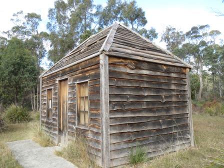
The
only building here was this replica hut but there was no information about it.
At least it was authentic looking with the slab cut timber.

The
flower that was named after Paterson.

Continued
along the road then onto a dirt road that looks like it was a logging road. Up
and over The Dazzler Range then we turned off and headed towards Narawntapu
National Park. It was the first Tasmanian Park to revert to an Aboriginal name
which is the name for the Badger Head/West Head area. We were at one end of it
near Greens Beach now we are at the other end.

Chatted
with the park ranger as we picked up a map of the walks in the park. Decided to
have lunch down at Bakers Beach. Great view west then east.


Looking out to the Bass Strait. The
waves just kept rolling in even though there was no wind. Turned into a
beautiful day.

After
lunch headed off to walk for 45 minutes to Archers Knob for a view over the
whole park. Up and over sand dunes where we could track all the different
animals.


Even
found a devil’s scat.

Along
the edge of the lagoon that has a bird hide – but it was hiding!!

All
the pademelons and wallabies were sleepy and soaking up the warm sunshine.

Nice
walk.


Then
we started up hill. It was a tighter zig zag track than the one up to Mt
Barrow.


Great
view though.


The
track was eroded.

Up
onto the top of the knob but we haven’t found the lookout yet.

The
blackboys are growing well here.

Looking
across to the Asbestos Ranges and the fire trails.

Found
the lookout and sat down to enjoy the view and eat our apples.

Looking
across to the range then around to the flat area around the National Park. Over
the lagoon to North East Arm and Baker’s Point. Shell and Rabbit Island in the
middle of the water. Port Sorell over the water then Griffiths Point on the sea
side of the Park. Across the bay to the point on the west side with the island
called ‘The Carbuncle’.


Zoomed
in on Port Sorell, Shearwater and Hawley Beach area.

Then
Shell and Rabbit Island.

Headed
back down. Looking up to where we were on the knob.

Decided
to walk down to Bakers Beach to walk back along it to the truck. The clouds
have come over so it is a bit chilly now.

Steve
pointing to where we had climbed.

We
went all the way around the base of the knob then zig zagged up the side then
walked around to the other side of it. We are sure there could have been a
quicker walk to it!!

Should
be a quicker walk back but we keep stopping to check out things. Huge
cuttlefish.


Hundreds
of shells. Collected a few more.


There
are so many dead starfish. I tried to put this one back together.


Seaweed,
coral etc.


A
dead funny looking crab.


Beachcomber
Steve found a new fishing rod.

Lots
of timber too. Wonder where this cut log came from.


I
found a complete scallop shell.

Hundreds
of mussels and pippies.

The
only birds are the Pied Oyster Catchers.

The
sun trying to peek through again make a great photo.

Even
found a tennis ball.

Found
a great big shell but it had someone living in it so we threw it back into the
sea.

At
last we arrived back to where we had lunch up on the dune. Looking back to
where we walked.


Drove
around to check out the camp area at Koybaa and then to the next camp area
called Springlawn Beach at Bakers Point. Nice enough. A pebbly beach with cute
little flat pebbles.


Looking
down the river then across to Port Sorell.


Then
we went out to Griffiths Point – thought of Dave and Wendy here. A lot more
rocks here that go out onto the point.

Looking
across Penguin Islands then to Spy Island and The Carbuncle and Griffiths
Point.


We are
now at the westerly end of Bakers Beach.

Collected
a few more little shells as we walked right out to the point.

Great
view back to the beach then up the inlet.


As
we headed out of the National Park the Forrester Kangaroos and Bennetts
Wallabies were all in the paddocks.


Looking
up at Archers Knob.

Back
through the forestry road and back to the van. The central door lock is playing
up on the truck so Steve pulled it apart. Looks like we have worn it out!! It was still early (4pm) so Steve got the fire
going. It was lovely to sit outside and enjoy the view.

Rang
Alan and Dianne to work out when we will catch up before we leave. Rang Uncle
John to confirm when we will be arriving on Wednesday. Had a great chat with
Wendy.
A
bit warmer tonight that we had the heater turned down low. At 11pm it was only
10.8 degrees outside.
No comments:
Post a Comment