The
wind didn’t come during the night. Still 30 degrees when we got up. On the news
there are fires near Ballarat. Rang Mum and texted Erica to let them know we
were ok. The wind has picked up but as the sun came out we decided to move over
under the pine trees to get the van in the shade. Nice view of the Mt Difficult
Range.


Headed
off to explore. Into Halls Gap (220m elevation) then up the narrow windy Mt
Victory Road. Passed unusual rock
formations on the edge of the Wonderland Range.

The
wind is a lot stronger up here and lots of branches and leaves are falling on
the road. Climbed up to 730m then down to 460m to the turn off to Mackenzie
Falls. Skipped the two lookouts as it is too overcast now so the views won’t be
too good.
A
few spits of rain came down but we decided to do the walk. The Grampians were
severely burnt in January 2014 – there are black trunks but most have new green
shoots.


Walked
down to Cranages Lookout where a plaque tells of the family who lived up here
and ran the kiosk.

Took
a couple of photos looking down to the top of the falls and the rock formations
above it.


Headed
down the walkway but then the rain got heavier and a flash of lightning then a
roll of thunder sent us scurrying back to the truck. Wet and cold – such a
change from dry and hot yesterday!!
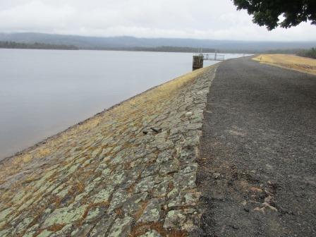
Decided
to do the walk tomorrow so went for a drive down to Wartook Reservoir which was
constructed in 1887 – Victoria’s oldest reservoir. Information about the
irrigation system that this reservoir feeds now.


Walked
out over the overflow to the wall.

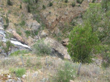
Water
rushing through to join the Mackenzie River.


Looking
over the reservoir – appears to be an island out there. There is a hut here for
the Horsham Angling Club. The clouds are hanging on top of Mt Difficult Range.


Continued
along the wall – amazing to think it was built over 100 years ago.


Back
down to where the water continues down Mackenzie River.


Down
on the overflow area was the information board – why isn’t it up in the
carpark? Hard to photograph under the glass cover.


The
rain has stopped. Drove down to Smiths Mill Campground on the Mackenzie River.
The weir used during the sawmill days here.


Stopped on the other side of the river where we found a broken info board where the single man quarters used to be.

On
the other side of the road was an old steam engine.

Back
into the campground to find the main info board which was on the wrong side –
the ranger came by and he said someone had put it up wrong!!


Using
the map we tried to find the other info boards – obviously not worried about
any more.


Steve
went searching for the jinker – hidden in the bracken fern. He remembers having
to pull it out at Woodgate as their block of land was covered in it. Found the
chain off the bulldozer.

The
jinker was buried so Steve set about clearing the area of the bracken. Then he
put the bars back in the correct spot.


The
sky has started to clear so we decided to go back to Mackenzie Falls.
As
we headed down I realised I was nearly out of battery on my camera so waited
till we got to the bottom to take photos.
Great
falls, worth the walk down all those stairs.


Huge
stepping stones.

Looking
up to the lookout we were on earlier.

The
river continues down and around the bend.


Crossed
back over the stepping stones and then followed the river downstream.


Looking
up to another lookout above us.

Looking
back upstream – lots of cascading falls as the river tumbles its way
downstream.


The
track continues on for another kilometre to another waterfall but we decided to
turn back. Looking upstream with the main falls in the background.

Started
the climb up the stairs (only 520m straight up) as the wind picked up and spray
the mist everywhere.

Major
Mitchell named the falls but the aborigines named it after the Blackfish.

More
stairs!!

Near
the top of the falls – looking down on the pool.

The
falls cascade over the rocks before falling to the pool below.


Upstream
the river is split in two before coming across this flat area.


Up
further looking down on the flat area then just the edge of the falls and the
pool.

Where
the river splits upstream.


Back
up to Cranages Lookout – looking further upstream of the river.

Across
the gorge to the road where the lady used to call out to the tourist bus to see
how many were coming for tea.


Back
to the intersection of the walks – the burnt trees regenerating.

140m
down to Broken Falls Lookout.

I
walked down to the old lookout which was further downstream. Looking back at
another falls below the main ones.

Then
the water continues downstream to then go over Mackenzie Falls.


Back
to the carpark where the Cranages had their kiosk and a 12 seated swing. They moved
here from the sawmill they sold to Harold Smith. The pathway down to the falls
was built by out of work men during the Depression of the 1930s.

Continued
around another walkway to the other lookout.


An
echidna waddles by.

No
sign on this chimney but we guess it was the old kiosk burnt in the 2014 fire.

Went
back to Smiths Mill to follow a dirt road across to Boroka Lookout. Still very
windy and now very cold too!! There are two lookouts – the first one gives
great views over all the fields.


Lake
Fyans in the distance.

Fabulous
views over Halls Gap and Lake Bellfield with Mount William Range on the left
and Wonderland Range on the right.


Zoomed
up onto Wonderland Range – looks a lot like the Blue Mountains.


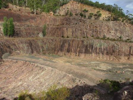
From
the wall looking over the Fyans Valley as Fyans Creek flows down through Halls
Gap.

At
least they didn’t have to transport the material to build the dam far.

Made
it to the other side (850metres – Steve was reading the markers on the wall).
The outlet.

Lake
and dam wall.


Walked
up the steps and around the hill left between the outlet and the spillway.

Zoomed
in on Mount William Range in the distance.

Back
across the dam wall and up the stairs in the observation tower.


Drove
down below the dam wall – the caravan park is here, bit creepy to live right
below it. These fellows don’t mind.

Steve
spotted a couple of emus as we headed back to Halls Gap.


Nearly
back to the campground and we saw two emus walk across the road.


Back
to the van where it was only 24 degrees – what a change from yesterday. Bit
cool now so we closed up the windows and put on the hot water for a nice hot
shower. The wind gusts are still strong but nothing has fallen from the trees
other than thousands of pine needles.
Our
fridge is happy again but they are forecasting more hot weather by Christmas.
No comments:
Post a Comment