Lovely
fresh morning, 25 degrees. Still cloudy but starting to clear. Headed into
Robinvale but Steve kept going and we went over the concrete arched bridge over
the Murray to Euston. The river is lovely and wide here because of the Weir
downstream. The weir pool itself stretches back 60kms to Meilman East – so we
are camping on the weir pool/Murray River.


Lots
of grape vines here too.

Stopped
near the old Court House which is now used by the Historical Society since
1981.


Walked
down the street checking out the historical plaques.


Lovely
tree in bloom.


The
club has prospered – major renovations under way.


Found
the dump point – funny to have it right beside the river!!

Erica
said she took a photo of a burnt out tree by the water’s edge but didn’t get a
shot of the other side. Here it is. She can compare the water level too as they
were here in Feb/Mar.


More
history – the punt which ferried all the goods before the old bridge was built.


Mum
and Dad Duck taking the kids for a walk up the main street.

Found
some interesting birds in the little park – made out of mechanical parts.

A
history board with a sprinkler going which sprayed my feet as I read the board
– very nice as it has heated up a lot. The sky has some funny high dark clouds
but don’t think they are bringing rain.


At
the end of the park near the river was more artwork depicting the steamer,
William Davis and barge. A newspaper article in the Sydney Morning Herald on 28
August, 1894 states: “The steamer, William Davis, arrived here on Saturday with
25 free labourers for Till Till Station. The men proceeded by coach yesterday
morning under police protection. On landing they were met by unionists pickets,
who tried to persuade the men to join the camp, but all refused. At Paika and
Canally Stations shearing is progressing slowly with the board half full.” Must
have been a shearing strike.

Steve
liked the Christmas sticker on the front of the pub.

Drove
down to the end of the town where I thought another history marker was but I
couldn’t find one. The river turns here and creates a backwater area (to the
left).

Back
over two approach bridges then the main bridge into Robinvale. Turned left at
the bridge to check out the huge windmill. It is said to be the largest in the
southern hemisphere.


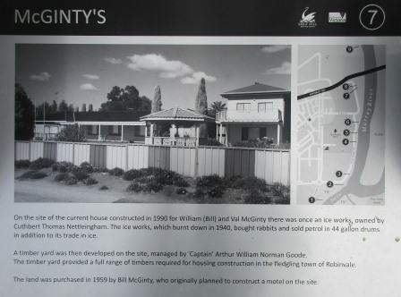
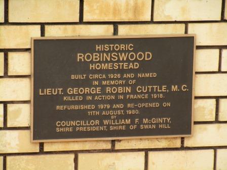
Across
the road is McGinty’s house who had bought the windmill when he wanted to build
a motel.

A
caravan park is on the other side of the road with full river frontage. We
drove down a bit to the boat ramp and picnic area. There is a pontoon to ski
off .


Across
the road in front of the Community Centre are two more bollards. First one is a
woodcutter – they lived beside the river, carting their own woodpiles with
horse and wagon. As a paddle steamer burnt more than a ton of dry red gum per
hour, they were kept busy. Boat captains would leave a note saying how much
wood they had taken and paid later.

Next
one was a Chinaman – Captain John Egge. He started working on riverboats in
1854, a year after the first boats travelled on the Murray. Twelve years later
he had his own boat and by 1870 he was one of the biggest boat-owners on the
Murray-Darling. He owned several boats and barges and many businesses on shore.
He was very generous to those in need.

Following
the river upstream we found more history plaques.


Passed
the aboriginal art centre then this plaque about the garden.


The
Cut is very interesting. It shows how it cuts across the land on the map
creating an island. It used to dry out but because of the weir it is always
full of water. Interesting depth change from 1.2m of the Cut area down to 9m in
the actual Murray River. Looking downstream then around the bend where the
Murray goes. Across to a little island and another little creek coming out of
Bumbang Island and then up the Cut to the Murray again in the distance.


The
old barge mentioned in the story.

Further
along found a better plaque with a great aerial shot.


Drove
back through town to the Info Centre.

I
asked about the old bridge over the Murray. She said it had fallen to pieces
years ago and they couldn’t let the semis on it and only two cars at a time so
they pulled it down and built the new one and the approach bridges on the NSW
side. It was opened in October, 2004. They kept the lift part which is further
down the road near the bridge on the railway line.
The
old railway station was behind it.


Checked
out the museum but it is only open Thursdays and Saturday so just wandered
around outside. Lots of the same things we saw at Swan Hill.


Walked
down to the old bridge lift-span section they have preserved. The bridge was
opened on the 14th March, 1928 with the oldest resident of Euston
cutting the ribbon before the official party went across on the train. They
couldn’t go the whole way as it wasn’t finished.


The
old train turntable and water tower.


Walked
back to the truck then headed down under the bridge. Found some old information
boards.


Steve
thought the bridge is an unusual design.

One
more of the new River Walk signs. Last
canoe tree I am taking a photo of – there has been so many!! This one looks
like it was the size of a canoe.


Headed
downstream along the dirt track. A few tent camps that look like they might be
permanent set ups. Steve spotted Mr Goanna heading for the tree.

Continued
around till we saw Euston across the river. They don’t have caravans here –
only house boats.

Zoomed
in on the van park where Erica and Terry stayed.

Lots
of these rustic picnic tables along the track.

Stopped
opposite the Bowls Club and boat ramp, where the punt would have crossed years
ago.
Zoomed
in on Erica’s tree.

Back
out the track to the bridge then back through town. Out of town a bit then we
turned off to find the Weir and Lock 15. Erica missed this one as it is called
Euston Weir but the entrance is downstream from Robinvale in Victoria.
Parked
in the shade beside a bush that I grew at home that was to bring us riches!!
Can’t remember its name.


Had
our lunch in the park. Steve plucked a burr from my sock then I had to pull it
out of his finger.


Unfortunately
the walkway was closed as they are doing work on the weir and the trees are too
tall for a good look.


Found
an info board near the office.

From my booklet – Construction of the Weir
commenced in 1932 and was completed in 1936 and was the last one built on the Murray. In 1987 the original timber
barricades were replaced with steel and gates were added, and the operation
changed from a manual to hydraulic one. 32,000 mega litres (a mega litre is one
million litres of water) of water flows through this system daily -That’s
amazing. Lock 15 is managed on a Tri-State agreement between NSW, Victoria and
South Aust. The management of the river is shared so that no one State has full
and total control over the water. Prior
to the Tri-State agreement communities downstream were disadvantaged by
decisions made upstream. The management of Lock 15 and the weir at Robinvale
includes maintaining the daily level of the weir pool at a constant 47.6 metres
above sea level (give or take 10 cms allowing for such factors as evaporation).
This is a manual operation performed by the Lock Masters. On occasion larger
volumes of water are released in instances where algae bloom need to be flushed
out downstream. Another important task performed by the staff at Robinvale is
the monitoring of fish. The Fisheries Department takes its breeding stock of
silver perch, perch and Murray Cod from fish that staff at Lock 15 collects. Robinvale
is only one of the two places along the Murray that this occurs, because of the
healthy size of the fish stock in this part of the Murray River. The staff
monitors the fish levels using radio trackers which trigger a data logger as
the fish finds its way through the Denall Fish Way (so named for the person who
invented the system) which is on the far side of the weir.

Chatted
with a chap and he said the fisherman walk down the track further along the
grassed area. Clearer view from here. They are lifting out the planks to lower
the weir level and let more water out. We went down the track to the weir.


The
old weir timber gate.


Looking
upstream through the open Lock gate – the chap was working on the gate.


Then downstream over the Lock then down to the river.


Some
carp were trying to get up through the water coming out through the Lock gates.
Not sure where the fish ladder is as we can’t go onto the weir.


They
are digging out dirt from the NSW bank and putting it on the barge.

Lovely
colour in the cliffs downstream. The shags are all resting.


This
marker shows the height of the 1956 flood.

Walked
upstream to where the steps came down – water height markers.

Looking
back over the Lock and Weir.


Mallee
Scrub that this area was covered in.

Back
to Walsh’s Bend but Steve went up another track and we drove passed where we
walked yesterday till we found the inlet pipes that we drove down beside on
Pipe Road.

Nearly
back to Robinvale via the river edge – another bend in this windy river.

We
had turned towards this spot because the road was blocked by a creek. Turns out
it is another anabranch of the Murray and this is where it joins the Murray
again.


Back
to the van. Glad it is in the shade as it is a very hot day. Looked at the info
about Mildura and then worked out which way to go down through the Grampians
and to meet the others in Terang on the 26th Dec. Rang Lou to check
on arrangements. Steve got his fire going right beside the river as he had lots
of extra timber and we haven’t had a fire for so long. Mind you it was too hot
to get too close.

Rang
Suzanne for a chat. Enjoyed having tea by the river as the sun set, eventually.
Cooling off a bit now so headed back into the van. The Mopoke is calling for a
friend while the crickets and frogs call out.
No comments:
Post a Comment