A
shower of rain during the night. All clear now though, 15 degrees at 8am but
still windy.
Headed
back down the track to the main road, passed a chicken farm. I thought I had
some long life milk as we are about to run out but I don’t!! Drove back a few
kms to Strathmerton to get some and to dump the dunny.
Headed
west again. Lots of brilliantly green Superb Parrots then saw a sign saying it
was a Conservation area for them near Bearii. Tried to get to the top of the
other section of Barmah State Park so headed onto the dirt roads but ended up
lost in all the pasture and hay fields and a pig farm.
Stopped
in Barmah where the Murray River has a big bend in it. Chatted with a chap who
said he was camping by the river before the National Park. He said to watch out
for brumbies and emus.

Turned
up the road to Barmah Lakes. Crossed over Broken Creek into the Barmah National
Park which used to be the State Park. Drove up to the Barmah Lakes camping area
and pulled over for a look around. Nice area but as usual of National Parks the
camping area is now set well back from the edge of the water. Of course the
Victorians don’t read the ‘no dog’ sign!!


This
area is where the Murray River has spread over a vast area and there are
islands in the middle.

We
walked down to the boat ramp and day use area then back to the other end. Found
the brumbies eating the lush grass by the river.


Decided
to check out the other area so headed back over Broken Creek then followed it
up till it flowed into the Murray River. A river distance marker on the NSW
side is 1772km. Broken Creek starts near Benalla where it branches off Broken
River. Broken River then travels the other way through Shepparton and then
joins the Goulburn River which then flows into the Murray too.


Drove
further downstream to find a spot and found another red marker on the Vic side.
A houseboat is moored on the NSW side.


The
GPS shows the area the Murray spreads over. The NSW side is called Moira Lakes.

We
are camped where the blue arrow is on Barmah Island. Creeks starting upstream
of the Murray cross across the land and then join the Murray downstream
creating islands.
Steve
found a bucket – that will replace the one he lost in Tassie!!

Had
some lunch then headed off to explore. Some people are carrying out fishing
survey by stunning the fish with electricity then recording details. They got a
carp while we were watching.


Headed
north past the National Park campground to the old muster yards.


An
old River Red Gum. I had been calling them Red River Gums but I have it right
now.


Carried
on along the track till we came to an aboriginal ceremonial place.


Further
along we turned off to Hut Lake. Lovely and lush here no wonder they grazed
their cattle here.


Lots
of brumbies here.

On
the edge of the clearing the trees are taller and closer together.

Back
on the track we continued on and arrived at Bucks Lake. This area is wetlands.
Crossed the bridge – the creek joins Tullah Creek and then flows into the
Murray at the top of Barmah Lakes. Worked out now that Tullah Creek was the one
we were travelling beside yesterday when we headed into the other camp area,
which we thought was a backwater.

Travelled
along beside the creek then we finally we arrived at the Murray River again,
upstream.

Not
much bank here so it could easily flood the wetland area.

Checked
my map to figure out where this creek goes.

Crossed
over the new bridge as the old wooden has been pulled down. We are on ‘Top
Island’ now as the Murray is on one side and the creek (from the Murray) goes
down and then joins the Murray again making us surrounded by water.

Now
we are following the Murray downstream. So many dead trees on the ground. Crossed
another creek but this one has gates on it. Not sure where this creek goes.


Across
the river is Picnic Point in NSW. Huge area with houses and weekenders.

Found
another red marked tree.


Crossed
another creek with gates. A sign says this one is called Island Creek.

Further
downstream is a caravan park.


Across
the Murray is another camp area. I called out to the chap to ask what it is
called – he said ‘Swifts Creek’. Looks nice and it has a flash boat ramp.


Our
GPS mark before we turned around and headed back up the track.

Took us an hour to get to the end but it is a nice
drive along the Murray.

Back
to where we can look across to the caravan park in NSW. The water is up high.


Crossed
back over the two gates creeks then the other one which we then follow back to
where it joins Tullah Creek here.

Back
to the Muster Yards where we noticed another sign. Should have read this one
before heading up. The map would have been helpful but at least now I can work
out what’s what. Tullah Creek flows into Smiths Creek which is what the top
creek was flowing into. I like figuring out exactly where we are and going.


Where
we are camping.

This
shows where we were travelled along the creek yesterday before going to where
we camped. We saw the sign for Ulupna Island at Strathmerton but didn’t realise
what it meant.


Information
about the area and some great photos.


There
is a walk about the environment from here but they haven’t maintained the signs
so they are hard to read. This one is about the floods seen here over the
years. Barmah Forest is subject to regular flooding and is an internationally
recognised wetland providing important habitat, particularly for waterbirds.
The ‘flood post’ indicates the water level reached during some major past
floods.

We
laughed at the sign ‘danger – deep water, no swimming’ in the background as the dam is empty now.

Nearby
is the Dharnya Centre, opened in 1985. Closed now.


Walked
around to the back to check out the ‘scarred trees’. Aborigines cut a slab of
bark from this tree. Bark was used to make canoes, shields, containers and
shelters.


Peered
inside the centre – lots of cobwebs on the windows so hasn’t been used in a
while. Inside was a bark canoe and displays etc.


Not
sure about the big fish!!

Zoomed
in on the boards about the Maloga Mission which was created in 1874 and the
petition the aborigines signed to get back their land – obviously the area we
saw today.


Walked
around to the other end.

Back
to the truck and we drove around the Muster Yards to read the memorial to the
men and families of the cattlemen here over the years.

Took
a photo of the yards and managed to get a fly too.

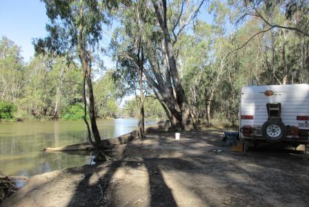
Back
to the van for a drink by the river. Lots of people fishing but there doesn’t
seem to be many cod caught. Got too cold to stay outside so headed in to cook
tea and write up my blog. Steve working his way through the Game of Throne
series. We are slowly figuring out who is who – bit gruesome so I am glad I am
typing while watching it.
Two
possums had an argument beside the van so I through them out the vegie scraps.
Cute little things.
No comments:
Post a Comment