19
degrees at 8am – what a difference to the 43 degree heat we had. The windows
are closed and we are under the blanket!! Overcast this morning but the clouds
are clearing as we head off.
Back
up Mt Victory Road and into Wonderland Road (410m elevation) – named because it
is in the Wonderland Range. First a 1.2km walk to Turret Falls via Pansy Falls.
It has an elevation change of 110m and as we walked along the track we realised
we are just below the range road. Looking back over the angled mountain side.

We
chatted with an Asian couple with two children as we walked along. They said
someone told them there wasn’t any water coming over the falls – now we find
out!! We kept going anycase. There are only puddles of water in Stony Creek as
we follow it upstream. Not sure where Pansy Falls is supposed to be but there
was a rock wall that could have been it. I walked off the track when I spotted
some water. It was where the creek was dribbling over a rocky ledge to make
Turret Falls.


There
was only a dribble going over so I walked over the rocky ledge to the other
side while Steve cleaned out the waterway to get some extra water over the
Falls.

Got
a bit more happening on the first waterfall.


Then
he got the other one going a bit better too.


That
was thrilling so we headed back down the track back to the carpark. Passed the
couple again as they gave up so I showed them a photo.

Walked
down to the start of the other walks and found a map and a photo of what Turret
Falls should have looked like. We will do the Grand Canyon walk now, it has an
elevation of 60m and is a 900m circuit with a medium grade. There is a shorter
walk with less elevation to The Pinnacle from the Sundial carpark (110m
elevation compared to this one which is 280m elevation).


Crossed
over Stony Creek which had lots of stones and only a little water!! Following
little yellow triangles over the rocks.


I
wonder how they set up all these huge stepping stones!!

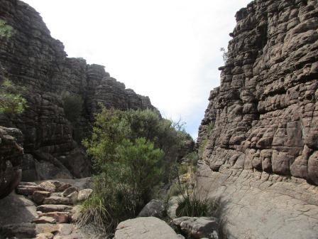
Fabulous
rock formations as we climb up into the Grand Canyon.


Looking
back towards the carpark.

Continued
on to the end then climbed the stairs.


Definitely
a ‘Grand’ Canyon – down then up.


Up
more stairs and out of the canyon.

On
top looking around and then down the canyon.


We
can just make out the carpark.


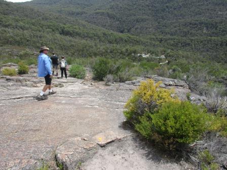
It
is like Fleet Street up here – so many nationalities. We can either that the
other track back to the carpark or 2.1km on to The Pinnacle. Since we were this
far we kept on – lucky we had brought our water bottles as it has warmed up now
on these rocks.


Found
a Cool Chamber though if we need it.

Steve
pointed out the covered up graffiti on the rock face.


Steve
reckons we have to go over that ridge to get to The Pinnacle.

Came
to an intersection where we could continue on another 1.2km to The Pinnacle or
take another route that was 3.2km – now which one should we take!! Short one of
course. That brought us to the Bridal Veil Falls – which would be nice if there
was any water.

Still
climbing over the rocks.


Looking
back down the side of the mountain towards the carpark.

More
climbing – has Wonga Mick been here?


Nearly
to the top of this slope.


Then
down into ‘Silent Street’ a narrow gap in the rocks. Pretty special I must
admit. Wasn’t very silent though with so many people coming and going.


The
view back.

Getting
narrower.


Out
onto the top again. Steve found a rock that needed pushing back up.


Up
a bit further then we turn to the left.


Looking
down to the carpark – WOW.


The
sun is warm but the breeze is quite cool. Looking across to Mt Difficult Range
and somewhere in there is Boroka Lookout.


Zoomed
in a ridge further south.

At
last we have arrived – The Pinnacle Lookout.


Wow
oh Wow – what a view even though we don’t have a clear blue sky. Looking across
the escarpment with Halls Gap below.

Some
people found a nice spot for their lunch – the crow joining them.

Panned
around then took a video.


Lake
Bellfield.

Time
for a selfie or two.


Zoomed
in on Mount William – we are planning to walk to that one – there is a road
most of the way up and then you have to walk the last 2km of the road to the
summit.


Looking
down on Halls Gap.

As
we didn’t bring our lunch we headed back before our knees seized up. Steve’s
aren’t happy and I have a pinch running down my right leg pulling on my knee –
we are cracking up!!
Back through the narrow bit into Silent Street.


Back
to the top of the Grand Canyon.

Took
the shorter track back to the carpark.
Nearly
down – I zoomed in on the gap between Wonderland and Mt Difficult Ranges to the
fields in the distance.


Made
it back to the truck. Glad we did the walk from here as we would have missed
out on the Silent Street which was amazing. Got our lunches and found a picnic
table to rest. The choughs entertained us trying to eat our apple cores.
Decided we needed a rest so headed back down the range to Halls Gap. We
rewarded ourselves with an icecream – Baileys & Macadamia for me and Stairway
to Heaven for Steve – though it wasn’t as good as Mures in Hobart.
Back
to the van where I worked on my blog and Steve read his latest magazine. Needed
to charge my laptop we went for a drive in the late afternoon. Headed in the
opposite direction towards Roses Gap. Turned in at Heatherlie Quarry sign but
it was a 1.2km walk – nah.
Continued
along the base of Mt Difficult Range and then past Briggs Bluff at the end.
There area was severely burnt in 2014.


Turned
left at Roses Gap – thought it might have been a narrow one but it was wide and
there was a Recreation Centre and accommodation place there. Continued up the
road to a camp area at Troopers Creek which is below Mt Difficult itself.

The
campground (a free one) was closed due to the fire. On the roadside was a sign
stating this road was ‘Old Adelaide Road’ and the other side explained why it
was called Troopers Creek.


Turned
around and headed back along Mt Zero Road. There were 4wd tracks headed up to
the base of the range so had a look – very soft white sand. Nothing at the end
so decided they must just be for fire access.

Further
along was marked Mt Difficult Track 4WD which runs along the base of the range
parallel with Mt Zero Road. Travelled along it for a while then a creek area
stopped us so back we went.

Back
to the van. Here is a map of the National Park etc.

Bit
cool again (23 degrees) so closed up the van and cooked dinner. Worked on my
blog – it does keep me busy.
A
few more campers have arrived. Beautiful colour in the sky as the sun sets
behind the Range.

No comments:
Post a Comment