Another cool morning. Packed up and headed back out to Parry Creek Road following a group with two big army vehicles. Turned northwards to head to Wyndham.
The hills have changed to chunks of rock.
.JPG)
.JPG)
Across Spring Creek which flows all year apparently. I missed the photo as I was reading the info about it. There is a short gruelling 4x4 track to an oasis. Going by the others we went into it might be too gruelling for us. Maybe a return trip.
House roof Hill stands out to our right. It is on the eastern side of the Ord River near a big bend in the river. The river turns north-west now and we are going to the west.

Rolling hill range along our left in the distance.
Turned off into Mambi Island boat ramp for a look. Not sure where the ‘island’ is. Supposed to be a picnic area here but we think it might have been washed away.
.JPG)
.JPG)
We enter Parry Lagoons Nature Reserve. Crossed a little creek then up a slope to an old chimney. Looks like they have dug out the dirt around it and boab trees to use for road base. The hills is covered in boabs. Further along there is an old metal water tank, a slab and a narrow cattle dip (we think) and some other small slabs etc. Might have been a homestead or outstation but there is not info about it.
.JPG)
.JPG)
.JPG)
.JPG)
.JPG)
.JPG)
.JPG)
.JPG)
.JPG)
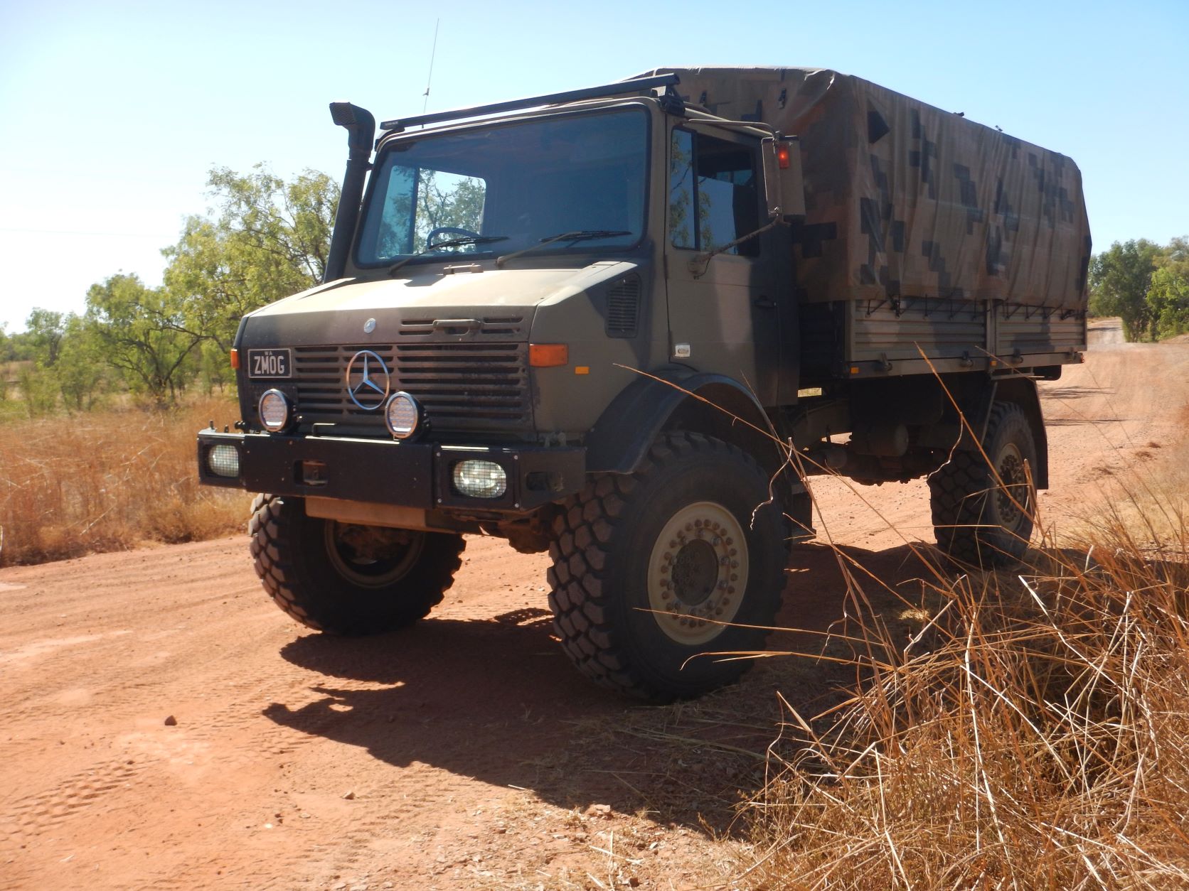
The chap with the big army truck (Unimog) pulled in. He was very interested in ‘Smokey’ as he has had lots of Nissans over the years. Left Steve chatting while I made a cuppa for us and some yummy banana cake (toasted too).
Past ‘wetlands’ - green grasses. The road is corrugated but not too bad.
Cross a little creek and spotted a blue-wing kookaburra fly off.
Turned down the Old Halls Creek Road. Pivot Hill is covered in boabs of all shapes and sizes.
.JPG)
.JPG)
.JPG)
.JPG)
In the 1850s when gold was discovered at Halls Creek a track between there and Wyndham was built in 1894. To help the track survive the wet season it was edged with brick paving. We drove down till we found some. I was looking for a gutter but it was flat on the road.
.JPG)
.JPG)
.JPG)
.JPG)
We turned around and headed back out then turned off again shortly after into Parry Creek Farm and campground. It is beside a long lagoon with a 3 metre salty so no adventure swimming according to the lady in reception. Nice campground too. There are cabins which are up high with a gang-plank walkway linking them on either side of the lagoon. We walked to the end of the lagoon - nice lilies, dry on the other side of the causeway.
.JPG)
.JPG)
Drove back out and checked out the other end. Looks like a home-made grader by the fence. Walked down to the billabong keeping an eye out for crocs before wandering down to take photos. Still trying to spot a Gouldian Finch - I could hear some finches in the grass but couldn’t see any. Steve took a photo of the finches on the fence in case we don’t see any.
.JPG)
.JPG)
.JPG)
.JPG)
Continued out on the dirt with nice hills to the left.
.JPG)
.JPG)
.JPG)
Turned off to the old Telegraph Station and Marlgu Billabong. Great information about the Reserve etc. Learnt the hills we have been travelling beside are part of the Erskine Range - it isn’t marked on the map or the Hema.
.JPG)
.JPG)
.JPG)
.JPG)
Continued up the track spotting 2 brolgas wading in the wet grasses.
Climbed up a small hill to the old Telegraph Station with fabulous views over the Ord River floodplains and Marlgu Billabong.
.JPG)
.JPG)
.JPG)
.JPG)
.JPG)
Did the walk around the remains of the telegraph station. A few Whistling Kites were calling out and we realised there were a few nests in the boabs. They are lovely to listen to and watch glide in the sky. Lots of boabs and kapok trees. Nice walk and great information too.
.JPG)
.JPG)
.JPG)
.JPG)
.JPG)
.JPG)
.JPG)
.JPG)
.JPG)
.JPG)
.JPG)
.JPG)
.JPG)
.JPG)
.JPG)
.JPG)
.JPG)
.JPG)
.JPG)
.JPG)
.JPG)
.JPG)
.JPG)
.JPG)
.JPG)
.JPG)
.JPG)
.JPG)
.JPG)
.JPG)
.JPG)
.JPG)
.JPG)
It is quite hot in the sun now. Down the hill to the billabong for lunch. As we headed in Steve spotted a log on the bank and when I zoomed in it was a good-sized croc. A big sign at the boardwalk entrance about crocs too.
.JPG)
.JPG)
.JPG)
.JPG)
I obviously hadn’t checked the door when I latched it last and it was only caught on the first latch so there was a bit of dust around the door but nothing inside so Steve’s pressure vents are working well.
The Birds of Prey board needs fixing up same with the others along the boardwalk. Zoomed in on the Magpie Geese who were honking away further along under and in the tree with the Ibis.
.JPG)
.JPG)
.JPG)
.JPG)
.JPG)
.JPG)
.JPG)
.JPG)
.JPG)
Walked around to the bird hide and sat and watched some little ducks duck and dive when the whistling kite flew over them. One lone Egret. Some magpie geese flew off.
.JPG)
.JPG)
.JPG)
.JPG)
.JPG)
.JPG)
.JPG)
As we headed out we noticed Mr Croc has turned around.

Continued along the dirt road across the ‘dry’ wetlands area. You can see where people have come in too early and got bogged in the grey dirt.
.JPG)
.JPG)
Onto the Great Northern Highway (bitumen) and continued north. Passed a big salt lake area then a few communities.
.JPG)
.JPG)
Stopped at the Information rest area. Nice Afghan and camel cut-out.
.JPG)
.JPG)
.JPG)
.JPG)
.JPG)
.JPG)
Continued along the side of the dry salt lake.
The Big Croc greeted us as we entered Wyndham (which is actually 3 Mile). The original Wyndham township is around the hills and beside the water of West Arm of the Cambridge Gulf. The Big Croc was built in 1987 - fabulous.
.JPG)
.JPG)
.JPG)
.JPG)
.JPG)
.JPG)
A chap named Steven showed us the information then offered us his carved boabs. Only small ones for $25 each. He has done a good job but we passed on the offer.
Around to the Warriu Dreamtime Statues. There was a plaque under a tree before it but the ‘locals’ were having a lovely time singing there (1980s songs) so we left them to it. One chap walked over as we headed up to the statues wanting to show us his carved boabs. Reminds us of Vanuatu with the locals trying to get you to buy their sarongs etc.
Sad to see the state of the ‘park’ here especially with these great statues.
.JPG)
.JPG)
.JPG)
.JPG)
.JPG)
.JPG)
.JPG)
.JPG)
.JPG)
Continued on past the Wyndham Outdoor Picture Gardens - didn’t look much other than corrugated fencing but it is the second oldest outdoor picture theatre in Australia.
Looking across to the salt lakes to part of the Cockburn Range.
.JPG)
.JPG)
.JPG)
On the other side is Mt Albany.

Around to the original township area. Checked out the info near the boat ramp.
.JPG)
.JPG)
Walked down the wobbly pontoon jetty with very muddy boat ramps on either side as they have very big tide differences here. Looking across to the new Anthon’s jetty then the Port jetty further along.
.JPG)
.JPG)
.JPG)
.JPG)
.JPG)
.JPG)
Mt Albany then to the left Mt Bastion where the 5 rivers look out is.
.JPG)
.JPG)
A bit further along was the new jetty at Anthon’s Landing with more information boards which are great. Of course another reminder about Estuarine (Salty) crocs. Interesting to read how the population has grown since they stopped culling them. Bit like Cairns, they will take over the place soon. Good spot for fishing too apparently though the water looks a deep dirty brown as the tide rushes past. Can’t see any crocs lining the banks though. The water flows north from here to meet the water from the Ord River in the Cambridge Gulf then out into the Joseph Bonaparte Gulf.
.JPG)
.JPG)
.JPG)
.JPG)
.JPG)
.JPG)
.JPG)
Steve went back and got the truck and I continued down to the corner to the Wyndham Historical Museum in the old Court House building. So many of these Bicentennial Trails haven’t been maintained - it was a few years ago I suppose. At least there are the new ones to give us the information.
.JPG)
.JPG)
.JPG)
.JPG)
.JPG)
.JPG)
.JPG)
Inside there so much information and photos and it is all well presented too. I took photos of interesting things I wanted to remember. You can spend a lot of time in here reading.
.JPG)
.JPG)
.JPG)
.JPG)
.JPG)
.JPG)
.JPG)
.JPG)
.JPG)
.JPG)
.JPG)
.JPG)
.JPG)
.JPG)
.JPG)
.JPG)
.JPG)
.JPG)
.JPG)
.JPG)
.JPG)
.JPG)
.JPG)
.JPG)
.JPG)
.JPG)
.JPG)
.JPG)
.JPG)
.JPG)
Found out more info about the MV Koolama which we learnt about on the cruise when we checked out where the captain had repaired the ship at Calamity Bay. To think he did all that, saved the passengers etc at Pangali Cove (which we went up into and saw a big croc and the lovely waterfall) and then it was bombed while tied up at the wharf here in Wyndham.
.JPG)
.JPG)
.JPG)
.JPG)
.JPG)
.JPG)
Outside was more info on the Koolama and other displays of old machinery etc. Amazing how these pilots survived.
.JPG)
.JPG)
.JPG)
.JPG)
.JPG)
.JPG)
.JPG)
.JPG)
.JPG)
As we walked back to the truck parked beside a big boab I spotted this huge nut. That would have been great to carve but it has cracked now.

Quick photo as we passed the Port Train Park of the display and the old sheds.
.JPG)
.JPG)
Can’t access the jetty to see where the Koolama had sunk as it is the new port jetty.
Continued around to the site of the Residency. Great view from here.
.JPG)
.JPG)
.JPG)
.JPG)
.JPG)
Headed back passed the turn off for The Gully - where there are residences and a newer cemetery. Back through the ‘old town’ - old buildings and big boabs. There is a huge one in the caravan park that is promoted as the ‘biggest in captivity’ with a circumference of 25 metre. Of course there are ones just as big in the bush.
.JPG)
.JPG)
.JPG)
Stopped at the Pioneer Cemetery tucked on a rise below Mt Dixon the hill. Mostly young people and workers from the Meatworks in late 1910s.
.JPG)
.JPG)
.JPG)
.JPG)
.JPG)
.JPG)
.JPG)
.JPG)
.JPG)
.JPG)
Back through town and around the Big Croc then through more residences - not the neatest of towns! Up the steep climb with 4 very sharp hair-pin turns that scored some rubber of the lazy axle tyres!
Fabulous views from The Bastion with views over the wetlands and the 5 rivers around here. Great direction plaque to work out what’s what.

Zoomed in on Mt Cockburn with the thin line of water which is the King River. Zoomed over the top of Mt Albany to the mouth of the King River.
.JPG)
.JPG)
.JPG)
Further along is the Gut where the waters from the Pentecost (left) and Durack (right) met to flow down into the West Arm.
.JPG)
.JPG)
Scanned around over the old Wyndham townsite and the port area. The wreck of MV Koolama is buried in the mud under the swirling waters.
.JPG)
.JPG)
.JPG)
.JPG)
.JPG)
Bit of history and a map is very handy.
.JPG)
.JPG)
.JPG)
Below is the site of the Residency.
.JPG)
.JPG)
More info about the Meatworks.
.JPG)
.JPG)
.JPG)
Moved further along the wall for more photos. Iron ore loading facility - doesn’t look like it is being used much.
.JPG)
.JPG)
.JPG)
Over the wetlands and zoomed in to where the waterway narrows then goes past Adolphus Island where it meets the waters from the Ord River, which comes in all the way over there.
.JPG)
.JPG)
.JPG)
.JPG)
.JPG)
.JPG)
Another board about the towns timeline as we walk around the other way to look over the new township which was 3 Mile. Great view across the King River to the Cockburn Ranges. The river wiggles its way across the flat plains.
.JPG)
.JPG)
.JPG)
.JPG)
.JPG)
One more plaque in the picnic area - fancy that, a genetic copy of the Mermaid Boab that we saw in Careening Bay on the cruise. Has a lot of growing to do.
.JPG)
.JPG)
The sun was getting ready to set so we headed down to find a camp spot for the night before it got too dark which happens so early at the moment. Stopped at another lookout on the way with views back down the Erskine Range that I took photos of as we came up.
.JPG)
.JPG)
An info board about the Cockburn Range but the sign is situated just a bit off where the mountains are.
.JPG)
.JPG)
.JPG)
Continued down to the main road then headed south. Turned off and checked out the Afghan Cemetery south of town.
.JPG)
.JPG)
.JPG)
.JPG)
.JPG)
.JPG)
.JPG)
.JPG)
Back on the main road then we turned onto the King River Road (dirt) which goes across the dry salt lake. The sun is setting on one side and the full moon is rising on the other - wonderful.
.JPG)
.JPG)
.JPG)
.JPG)
.JPG)
Around the base of the hill and continued along till we found a track down to a small creek and parked up for the night. Lots of mozzies as we took a few photos then into the camper for drinks then dinner.
.JPG)
.JPG)
.JPG)
.JPG)
.JPG)
.JPG)
All quiet here.
No comments:
Post a Comment