Beau is 2 months old today. He will be so much bigger when we see him next week at Byron Bay.
Woke to the pitter patter on the roof and we are surrounded by a foggy mist. 14 degrees so we put the heater on for breakfast. Worked on my blog and Steve read till 10am when the mist started to lift.
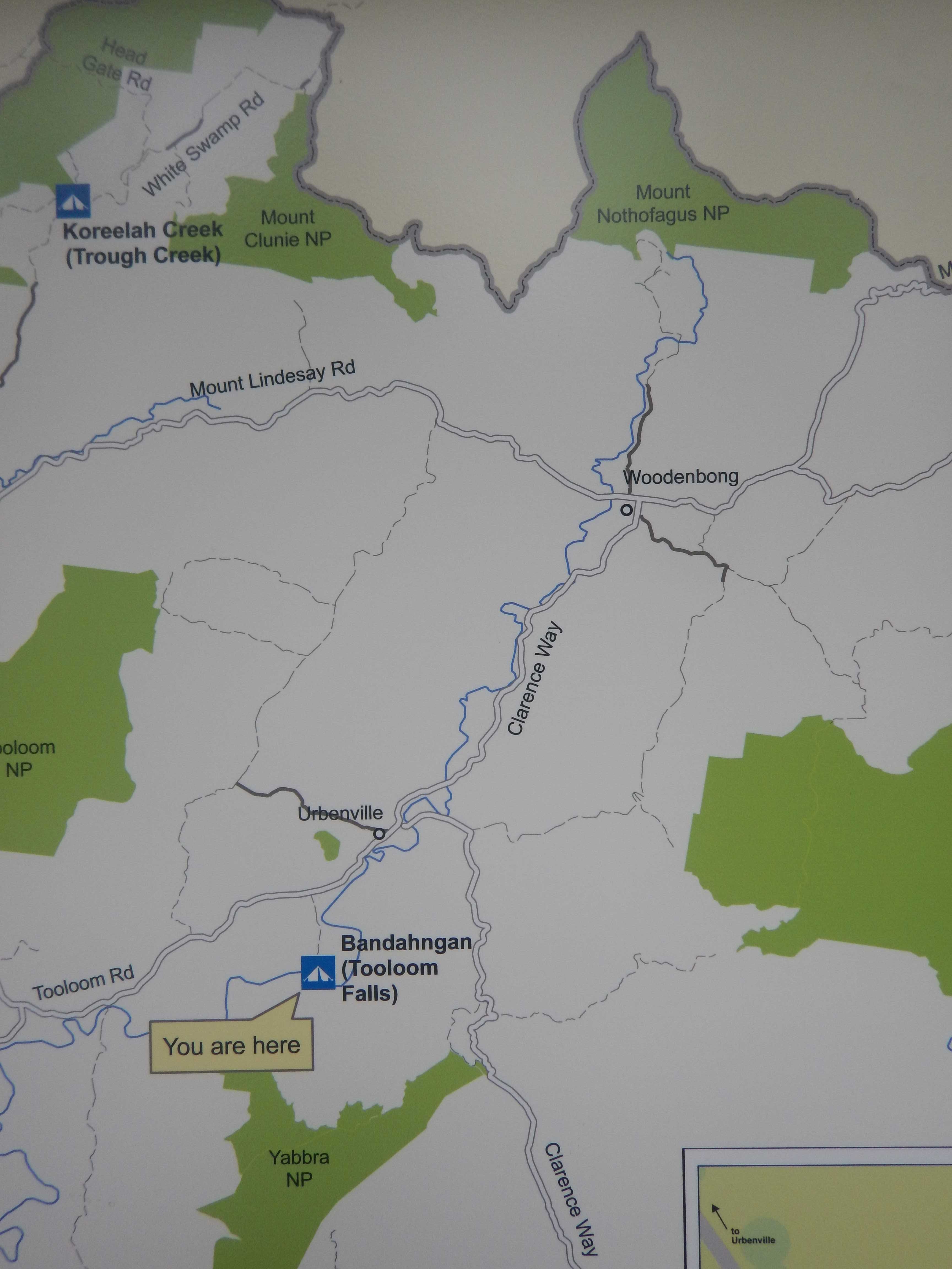
We headed off - the other couple were packing up too. We turned up the Mount Lindesay Road towards Woodenbong - wonder where that name came from?
No views as the mist is still low on the hills as we work our way along a nice new section of road. We are at 625m elevation then we started to descend winding around the hillsides to 390m to cross a one lane bridge which is quite impressive over a good flowing river, Koreelah Creek. There are two houses on the other side.
.JPG)
.JPG)
Climbed up then passed the turn off to Tooloom Lookout - no point today with this foggy mist about. Climbed up to 420m through rolling grassy hills.

Running alongside the creek now which I would call a river with the amount of water in it. Through the valley then we climbed to 530m and then down a winding road around the sides of the hills. Through more cattle grazing farms then we climbed again into natural State Forest to 600m and back into the fog.
Down through thin tall trees which look majestic on the side of the road. Descended to rolling hills and farmland again - still in the fog at 450m.
Into Woodenbong at 390m, surrounded by the fog. Nice little village. Interesting carving on an old tree stump.
.JPG)
.JPG)
.JPG)
Lots of information about all the national parks around this area. Interesting and confusing - in two places on the info boards it states the meaning of Woodenbong by the local Githabul - ones says ‘place of trees’ and the ‘local waterholes’, so whoever wrote this didn’t check what they were writing to make sure the meanings were consistent!
.JPG)
.JPG)
.JPG)
.JPG)
.JPG)
.JPG)
.JPG)
.JPG)
.JPG)
.JPG)
Misty rain started again so we headed to Urbenville. Another quaint little village. We walked along checking out the new history signs.
.JPG)
.JPG)
.JPG)
.JPG)
Turned and headed up the road to the old Police Station - needs a goat to eat all the grass down! There was an old church further along but it is now a private residence with a big barking dog and lots of trees out front that you can’t see it any case.

Back to the camper and onto the road to Tooloom where gold was found here in the early days. We are looking for water this time - Tooloom Falls. Lots of parrots zooming about as we turned down the Falls Road and made our way along the 3km gravel road dodging the wet pot holes. Into the small National Park campground and picnic area. About $26 to stop for the night but no NP entrance fee. Good map.
We parked up and had lunch then walked over to the top of the falls which was only a short walk away. Flowing well from the recent rain.
.JPG)
.JPG)
.JPG)
An Azure Kingfisher flew out the tree beside me and zoomed across the water flashing it’s beautiful colour as it disappeared up the river.
There used to be a road going across the top of the falls - you can see the road and a gap which would have been a bridge to allow the water to go underneath it. Forestry area on the other side.
.JPG)
.JPG)
.JPG)
We walked down the track to the bottom where the water is just lapping the edge and had recently been over the little ‘bridge’.
.JPG)
.JPG)
.JPG)
.JPG)
.JPG)
.JPG)
.JPG)
Someone else arrived so I took a photo of the person to show the height of the falls.

Headed back and spotted Coutts Crown - but the top is shrouded in the mist.
.JPG)
.JPG)
Back to Urbenville, passed Stephen St - should have stopped for a photo with Stephen!!
Back on Clarence Way and south to Old Bonalbo. Into lush natural State Forest with lots of straight tall white gums lining the road as we wind our way around the mountain edges.

Slowly descending - now sections of palm trees.

Roadworks - definitely need fixing. Down to the open valley (280m elevation) and farms. Up again to 315m then we spotted a sign about another set of falls - Beans Creek Falls. Turned off onto a narrow gravel road and drove past the sign to the falls - all overgrown. We pulled up in the small turn around area and backed into the flattened grass area. Walked back to the sign, we can hear the falls so decided the falls can’t be too far away.

You could just make out the path then it got clearer as we turned around the corner. Only one obstacle to climb over.
.JPG)
.JPG)
Down a few steps and onto a small platform. Definitely worth the walk down, especially with all the extra water going over it.
.JPG)
.JPG)
.JPG)
.JPG)
Huge pine tree reaching high up into the sky.

Back to the top of the falls where I noticed a small track heading down to the creek. Looks like nice spot for a dip when it is warm and sunny.
.JPG)
.JPG)
.JPG)
Made it back up as it started to drizzle rain again. We decided this will do us as a camp spot for the night and levelled the truck and headed inside as the rain got heavier.

I worked on my blog and Steve read. No phone reception here. We can hear the falls clearly which reminds us of staying with Jon & Annalise with the water noise from the falls and creek there. Lots of bell birds calls too.
I made pumpkin soup and kept some mashed pumpkin to make a cake for the kids when we get to Byron Bay. It is quite chilly so we are looking forward to warm soup to warm us up though the heater is doing a good job too.
Quiet afternoon reading then we watched a movie after dinner. Continually pitter patter on the roof as the sky keeps dripping on us.
No comments:
Post a Comment