5.30am
16 degrees and still dark.
As
we headed off the pre-dawn colours were creeping across the sky. Still dark on
the mount.
Headed
around the other side of the mount as the sun started to shine on it.
Steve’s
all set for the big hike. I made sure we had our trusty Tassie walking sticks –
certainly makes a difference especially coming down hill.
The
information from the brochure and in the picnic hut.
Off
we go, 12km to go till we are back at the truck again.
First
of the uphill bits.
Lots
of quartz rocks and veins stuck in the main rock.
Plenty
of stops for a rest and a photo of the sun on the next hill. The sunshine is
creeping towards as it rises on the other side of the mountain.
More
climbing ahead. We have reached the first section (110m above carpark) having
done the ‘gentle gradient’ bit for 1.5km. This is where you can cross over to
the Gully Trail.
The
sunshine is getting closer.
Now
for the ‘steep gradient’ for 1.5km.
The
sun is just reaching our truck down in the carpark.
We
continued across the top of the Gully then around the edge of this escarpment.
Heading
to the sun.
The
sun is now heading up the mountain.
Further up the sun is on us now as we head we continue upwards.
Reached the next junction of the Gully and Summit trails (450m above the carpark). Now for 2.7km of ‘gentle gradient’. We are doing well considering we haven’t done and ‘climbing’ for ages.
Great
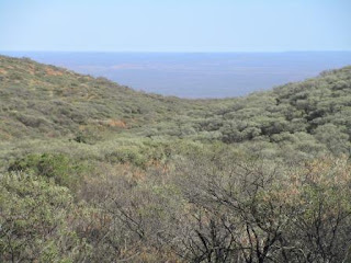
view on a ridge way below us.
Easy
going as we work our way along the creek except for the spinifex scratching our
legs.
Lots
of glistening spider webs in the trees. There have been a few pretty flowers
along the track. Amazingly there have only been a few flies so haven’t needed
my fly net.
Crossing
over the top of a saddle. We spotted a car on the track way below us.
Looking
back – we came up through the u bit on the right and across the saddle to here
and now we are crossing another gully section.
Onwards
– hopefully up this wall is the summit.
Hazy
view of the other side - our van should be down there somewhere.
Came
to a wall which is the last 300m of steep gradient – that got that one right!
Then it levelled for a bit till the next climb.
A
lady we met at sunset was just coming up behind us. We had had a muesli bar and
another one had fallen out of my bag which she picked up for us. She came up
the Gully Trail which has lots of boulders but she said it wasn’t bad. She
loves climbing mountains so is a lot fitter than us.
View
from the flat spot before the last climb up.
We
made it – 650m above the carpark and 1105m above sea level. Forgot to check the
time we actually left but it was probably around 6.30am and we arrived at
9.20am so not bad as I stop a lot to take photos and rest. We have phone
reception here which is strange as there is no reception at the campground. A
couple of texts came through. One from Kerry and Brian about another detecting
spot at Halls Creek so I sent her a reply that we were standing on top of the
World’s Biggest Rock. Then I sent texts off to the boys, Erica and to Tracy
& Jacinta Pink as they will appreciate the effort. I gave Mum and Dad a
call.
Took
a video of the view though it is a bit hazy. The Tourist Park is below us.
There
is a picnic table with a box containing a note and visitors’ book. We signed it
and chatted with Nadine while we ate our nibbles and had a drink. Nadine is a
veterinarian and is touring for 6-12 months looking for mountains to climb. She
had a ball in Tassie. I told her about Jacinta and all the amazing places she
has climbed.
I
took some photos of Nadine on top of the cairn that a Park Ranger made. He and
others carried cement and water up here to build it – wow.
We
can see more of that ridge we saw before.
Nadine
took a photo of us.
We
chatted for a bit more then we headed back down (10am). We felt good after
getting to the top but the legs will know about after we get back down!
Made
it down the steep bit and then along the creek area which was good. Reached the
trail junction and decided to take the Gully Trail back. Met two families with
young girls heading back up – it has warmed up a lot so I hope they have enough
water. One Dad commented that he wanted to climb it so he has to suffer the
consequences such as having to carry the youngest daughter! Oh to be young and
fit again.
The
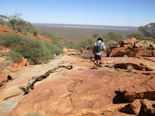
Gully Trail started out with flat rock sections then the boulders started.
Those kids climbed up this so it should be too bad – right! We are following little
dots to guide us down.
I
think we made a bad choice as I forgot this was a Grade 5 part and this was the
harder section of the track. Oh well we had gone too far to turn back when my
legs decided to give me hell. The tendons on either side of my knees started to
scream. I am so glad I had my walking stick or I might still be sitting up
there.
At
last I can see the carpark but we still have 2km to go.
Made
it down those boulders and back onto flat rock again but of course it is
sloping downhill.
We came
to the next junction and decided to take the Summit trail back down as I don’t
think I could do one more boulder. Slowly, slowly I made it down the trail.
We
made it back down – it is 1.20pm so amazingly we weren’t too slow. I quickly
downed some paracetamol and ibuprofen with a big drink of water. We certainly
drank more coming down in the heat. So glad we started in the cool of the
morning. Had some lunch and amazingly my knees felt better after the rest.
We
walked back along the track then headed up the Gully Trail again for 200m to
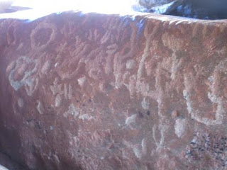
find the Flintstone Rock. Under the large slab some aborigines have left some
etchings in the rock.
Steve
climbed up the slab as he thought the etchings were on the roof.
They
were on the rocks on either side of the little stream – not very exciting. We
have seen much better ones at Meentheena on the Nullagine River.
My
knee tendons started to complain again as we walked back down the gully so I
don’t think I will be climbing to any more lookouts today.
We
drove back along the track to check out The Pound. It is an impoundment where
they kept the cattle as they drove then from station to market.
I
felt ok so we decided to do this little walk up to the saddle.
At
the top with a view over the Pound and then the other side where the Lyons
River was – bit hard to make out though.
As
we have climbed the Summit we decided we don’t need to do the lower lookouts as
the view is the same. Drove back past the Summit Trail carpark then continued
around the base of the mountain taking photos as we went.
We
think this is the saddle we walked across the top of to get to the other side
and the Summit.
Next
section of the mountain.
Found
a clear area for a good view back over the mountain from south end.
Turned
in to check out some more petroglyphs made by the Wajarri people. Again not
very distinct images.
Steve
found some more in a cave further around.
The
quartz wall and veins in the ceiling were more interesting.
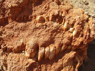
Could
these be dinosaur teeth?
Continued
around the Loop Drive past another site with engravings and a trail up to
Edney’s Lookout. A red-breasted robin flew out in front of us – so cute.
Around
to the south-east side. You can see the little lump of Edney’s Lookout. The
lump is supposed to be the spear end sticking out of the man’s leg that was
speared by the aborigines in their dreamtime story.
There
are another two lookout walks on the east side but we are happy with what we
have seen and done. I don’t want to do any damage to my knees.
Back
to camp for a cuppa and rest. Looking forward to a nice hot shower. A group of
13 vehicles arrived apparently causing a bit of havoc while we were out. One
lady came over asking our advice on the Summit walk as she had been in a car
accident and has a damaged leg.
Nadine
joined us for a drink and I showed her where more ‘rocks’ were in the wheat
belt for her to climb. Sharyn and Stewart joined us for drinks too. They are
going to do the climb tomorrow. A gusty wind has come up after the sun had set.
Leftovers
for dinner as I figured we would be needing to rest after our big hike. The
wind got stronger into the night.


No comments:
Post a Comment